Sunday, August 30, 2026

Syria Control Map & Timeline: The End of the SDF - August 2026 (Subscription)

SUBSCRIBERS CLICK HERE TO VIEW FULL ARTICLE AND MAP:
Old Portal (members.polgeonow.com) | New Portal (controlmaps.polgeonow.com)


To see other maps in this series, view all Syria updates on PolGeoNow. 

Researched and written by Djordje Djukic and Evan Centanni. Map by onestopmap.com, Djordje Djukic, and Evan Centanni.  
 

Join for full access to all conflict map reports

Thumbnail preview of post-Assad Syria control map: Territorial control in Syria on August 30, 2026, a year and a half after the fall of the Assad government. Color-coded for control by the Syrian Transitional Government (STG) of Ahmed al-Sharaa (formed from former rebels of Hayat Tahrir al-Sham (HTS / Al-Nusra Front), Free Syrian Army, and Syrian National Army rebels backed by Türkiye (Turkey)); remants of the officially-dissolved Syrian Democratic Forces (SDF), including Kurdish YPG and Asayish; the Israeli military (IDF) occupying forces; the so-called Islamic State (ISIS/ISIL); and the Druze National Guard paramilitary force in Suwayda/Sweida province. Also marks remaining Russian bases, recently vacated US base, and areas of major activity involving ISIS in the last five months. Marks locations of recent military importance, including Qasrak airbase, Kobani, Hmeimim airbase (Khmeimim), Mount Hermon (Jabal al-Sheikh), Semalka border crossing, Shahba and Arman (targets of Jordanian airstrikes), al-Mazraa, Ma'ariya, Rmeilan (Rumeilan, Rmelan), the Bishri Mountains, the Safa volcanic area, and many more. Colorblind accessible.

In the past five months, independent Kurdish-led control of the northeast has melted away under a merger agreement with the Syrian national government, leading to this week's announcement that the Syrian Democratic Forces (SDF) have formally ceased to exist (however, claims that integration is complete are greatly exaggerated).

In the southwest, Israeli forces have held their ground and dug in (literally), amid a threat of Israeli civilian "settlements" in the zone, while deep cracks have appeared in Sweida (Suwayda) province's Druze paramilitary "National Guard" coalition, with its leader charting an increasingly controversial political course both internally and externally.

Meanwhile, fighters of the "Islamic State" (ISIS/ISIL) have dramatically reduced their pace of attacks across the country, despite the withdrawal of most US troops, while on the coast, Russia has agreed to share its bases with the Syrian military.

Find the answers to all your questions in our professional report, with full summaries of each major trend and topic, and a detailed, painstakingly-researched timeline of events, with sources cited. Both the timeline and summaries are crafted with care by our dedicated humans - no AI slop. Also included, of course, is the latest update to PolGeoNow's concise, professionally-designed overview map of territorial control in Syria. Subscribe now to see it all.

The included map is dated to August 30, 2026, with the report covering events of the past five months, since the publication of our previous map and report on March 25, 2026.

This map and report are premium content, available to paid subscribers of the PolGeoNow Conflict Mapping Service. Please consider subscribing to support our independent, politically-neutral research and cartography, as we rely largely on readers like you, and are currently struggling for funding.

Want to see before you subscribe? Check out our most recent FREE SAMPLE Syria map report.*

*As conflict has slowed down in Syria, our 2026 reports include deeper coverage of the country's military and administrative landscape than seen in this sample report, with less of the play-by-play chronicling of military movements. 

Exclusive map report includes:

  • Up-to-date illustration of current territorial control in Syria (excluding the Israeli-annexed Golan Heights), color-coded for the Syrian Transitional Government (STG), formed from former rebel groups led by Ahmed al-Sharaa; the last remnants of the Kurdish-led Syrian Democratic Forces (SDF) and affiliates (includes Asayish police and DAANES Rojava government); forces of the so-called "Islamic State" (ISIS/ISIL); the Israeli military (IDF), and the Druze paramilitary coalition known as the National Guard in Sweida (Suwayda) province.
  • Markers showing the location of Russian military bases, and the US's recently-evacuated Qasrak airbase
  • Illustration of major recent active zones for "Islamic State" (ISIS/ISIL) operatives in areas outside the group's control, approximated from ACLED data on incidents both targeting them and perpetrated by them
  • Detailed indication of city-by-city control, including key towns and other locations important to current events
  • Locations of recent control changes and other important events, including Kobani, Hmeimim airbase, Mount Hermon, Semalka border crossing, Shahba and Arman (Jordanian airstrikes), Al-Mazraa, Ma'ariya, and many more
  • Concise, beginner-friendly summary of the current situation and key events over the past five months, covering major developments and trends for each of Syria's major armed parties and administrations
  • Detailed timeline of changes to territorial control, major military events, and key political developments since March 25, 2026, with background explanations and links to sources.

SUBSCRIBERS CLICK HERE TO VIEW FULL ARTICLE AND MAP:
Old Portal (members.polgeonow.com) | New Portal (controlmaps.polgeonow.com)


Not signed up yet? Click here to learn more about our professional subscription service 

Can I purchase just this map?
This map and report are not available for automated purchase to non-subscribers. If you need access or republication rights for only this map report, contact service@polgeonow.com for options.

Tuesday, July 28, 2026

Map Only: Somalia in April 2026 (Subscription)

SUBSCRIBERS CLICK HERE TO VIEW FULL MAP:
Old Portal (members.polgeonow.com) | New Portal (controlmaps.polgeonow.com)
 

(To see other maps in this series, view all Somalia updates.)

Thumbnail: Somalia war map 2026: Territorial control map showing security situation as of April 15, 2026. Marks states, regions, and territorial control, including by Federal Government of Somalia (FGS) in alliance with so-called Ma'awisely (Macawisley, Macawiisleey) militias, the African Union's AUSSOM peacekeepers (formerly ATMIS), and forces of newly-recognized North East State (formerly SSC-Khatumo, SSC-Khaatumo); Al Qaeda affiliate Al Shabaab; so-called Islamic State (ISIS, ISIL, IS-Somalia, ISS); separatist Somaliland; and autonomous states Puntland and Jubaland. Also includes boundaries of the additional federal member states, Galmudug, South West, and Hirshabelle. Shows Jubaland control separate from federal control amid the ongoing standoff between the two, and also labels state capitals and disputed territory between Somaliland and Puntland. Includes estimated areas of Al Qaeda and ISIS presence in the Golis Mountains (Cal Madow and Cal Miskaad) of northern Puntland and Somaliland. Colorblind accessible.

We're still midway through the process of preparing a full 2026 Somalia Control Map and Report, but subscribers who just need the map can find here a “preliminary edition” based on research up to April 15, 2026. 

This map is researched and fact-checked to approximately the same high standards we apply to reports, but is missing the report itself, which would cite our sources and document what changes have occurred since our previous map report in June 2025. That documentation will be covered in the final report coming later this year, which will also update the map up to the present date at that time.

Subscribe for full access to all conflict map reports!

This map is premium content, available to paid subscribers of the PolGeoNow Conflict Mapping Service. 
 
Want to see before you subscribe? Check out our most recent free sample Somalia map


More Somalia Services

PolGeoNow is a world leader in expertise on the geographic details of conflicts in Somalia, with various government and NGO customers relying on us for rigorously-investigated maps of territorial control. The above map is created with reference to PolGeoNow's proprietary database of village-level territorial control assessments, covering the entire territory claimed by Somalia. If you have questions about the sources and rationale for specific mapping decisions, please contact our lead cartographer and we'll be happy to provide answers.

If you're in need of deeper or more detailed information than shown on the map, you can also now contact us for additional services, tailored to your budget. The following are available on a short timeline:

  • Licensing of our Somalia maps for use in your own publications (can be included in custom subscriptions)
  • Direct consulting on subjects like fine-grained territorial control, accurate location of events, and recent history of control for specific locations going back to 2023
  • GIS data consisting of points for towns, villages, and other locations with columns for assessed territorial control at specific points in time; for areas covered by conflict reporting in recent years, this also includes added and corrected locations beyond what's found in widely-available datasets such as OCHA humanitarian info, Google Maps, and OpenStreetMap
  • Place name data documenting the myriad ad-hoc spellings seen in Somali and English-language reporting, to help you quickly find locations mentioned in reporting

With greater lead time, we can also offer services such as:

  • Customized map editions showing the situation on your date of choice (present or past), incorporating additions or modifications as needed for your use case
  • Close-up maps showing territorial control in much more detail for specific states, regions, or areas
  • Shapefile polygons for incorporation of our actual mapped lines of control into your own GIS workflow
  • Mapping the locations of military bases or checkpoints used by the various conflict actors (as compiled from publicly available reporting - we do not do our own ground-truthing research or have access to confidential sources).

For any of the above services, you can directly email Evan Centanni, our lead cartographer and Somalia researcher, at evan@polgeonow.com. All Somalia-related inquiries will be read and receive a timely reply. Have another idea? Run it by us! 

Get in Touch


Sunday, June 14, 2026

World Cup 2026: Which Countries Are (and Aren't) Members of FIFA?

This is an updated edition of our FIFA member countries article, updated and fully revised for the 2026 World Cup in North America! You can also view past versions of the article from 20142018, and 2022.

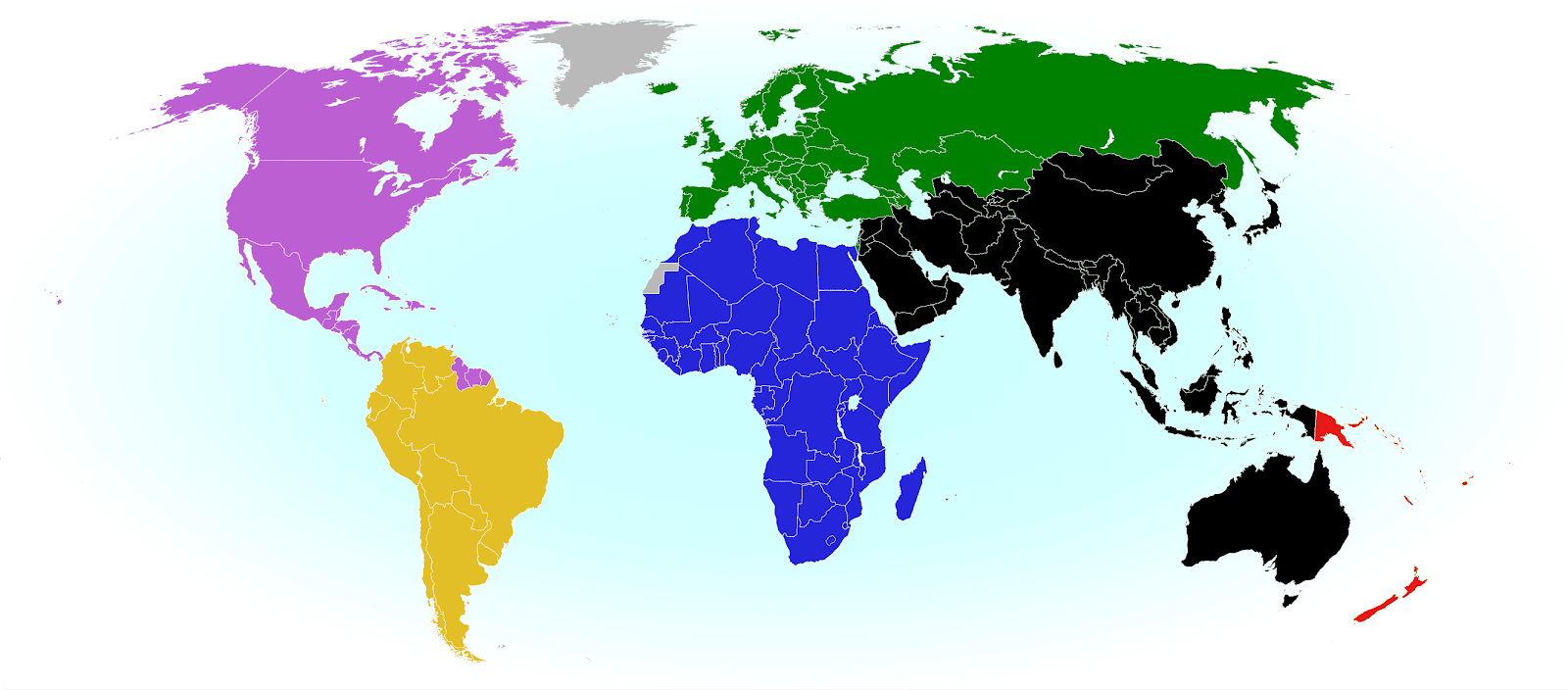
2022 world map showing the six continental confederations of men's national association football (soccer) teams, including all FIFA national teams and World Cup countries. Colorblind accessible.
The six continental confederations of national football teams associated with FIFA. Most, but not all, confederation members are individually members of FIFA too. Map by Evan Centanni, based on work by EOZyo (source).


Around the world, fans of association football - also known in many countries as "soccer" - are about to tune in for the ongoing, month-long men's FIFA World Cup in the US, Mexico, and Canada. Not all the world's countries can advance to the cup, but did they all get a shot at it? Which countries were eligible to enter the tournament, and which are excluded? Read on for PolGeoNow's exclusive guide to the roster of FIFA national football teams...

Wednesday, March 25, 2026

Syria One Year On: Conflict Timeline & Map of Control after Kurdish Retreat - March 2026 (Subscription)

SUBSCRIBERS CLICK HERE TO VIEW FULL ARTICLE AND MAP:
Old Portal (members.polgeonow.com) | New Portal (controlmaps.polgeonow.com)


There are newer editions of this map available. To see them, view all Syria updates.

Research by Djordje Djukic and Evan Centanni. Map by onestopmap.com, Djordje Djukic, and Evan Centanni  
Subscribe for full access to all conflict map reports!

Thumbnail preview of post-Assad Syria control map: Territorial control in Syria on March 25, 2026, more than a year after the fall of the Assad government. Color coded for control by the new Syrian Transitional Government (STG) of Ahmed al-Sharaa (formed from former rebels of Hayat Tahrir al-Sham (HTS / Al-Nusra Front), Free Syrian Army and Syrian National Army rebels backed by Türkiye (Turkey)); Syrian Democratic Forces (SDF) including Kurdish YPG and Asayish; Israeli military (IDF); so-called Islamic State (ISIS/ISIL); and Druze National Guard paramilitary force in Suwayda/Sweida province. Also marks remaining Russian bases, remaining US base, and areas of major reported 2026 activity involving ISIS. Marks locations of recent military importance, including Shadadi (Shaddadi), Al-Hol (Al-Hawl), Rmeilan (Rumeilan, Rmelan), Qasrak base, Kobani, the Tishrin Dam, Sarrin, Qatana, Jableh, Baniyas, Hmeimim airbase (Khmeimim), Mount Hermon, Qalaat al-Jandal, the Bishri Mountains, the Safa volcanic area, and many more. Colorblind accessible.In the 14 months since our last report, waves of violence have punctuated the new Syrian government's mostly-successful consolidation of power. Most recently, Kurdish-led SDF forces have retreated - in the face of a government offensive and widespread defection of non-Kurdish units - from most of the independently-governed zone they've long guarded across north and east Syria.

Before that, major campaigns included a brief but bloody rebellion in Syria's coastal provinces, then a small war over Suwayda province in the south. In both cases, government and allied forces carried out apparently genocidal massacres of civilians from religious minority communities: first targeting Alawite people near the coast, then Druze people in Suwayda. 

Meanwhile, the so-called "Islamic State" (ISIS/ISIL) has renewed its insurgency in Syria, while some of its fighters - and tens of thousands of their family members - are believed to be free after the messy transition of detention camps from SDF to Syrian government control. Elsewhere, Israel has expanded its occupation in the southwest, Russia has maintained its bases in the country, and the US military is in the process of withdrawing.

All your questions are answered in the detailed, carefully-researched timeline included with this report, covering events since our previous report of January 9, 2025 (more than one year ago), with sources cited. The report also includes fuller summaries of major trends, and of course an update to PolGeoNow's concise, professionally-designed overview map of territorial control in Syria.

This map and report are premium content, available to paid subscribers of the PolGeoNow Conflict Mapping Service.

Want to see before you subscribe? Check out our most recent FREE SAMPLE Syria map!

Exclusive map report includes:

  • Up-to-date illustration of current territorial control in Syria (excluding the Israeli-annexed Golan Heights), color-coded for the new Syrian Transitional Government (STG), formed from former rebel groups led by Ahmed al-Sharaa; the Kurdish-led Syrian Democratic Forces (SDF) and affiliated Asayish police; resurgent forces of the so-called "Islamic State" (ISIS/ISIL); the Israeli military (IDF), and the newly-unified, government-resistant Druze paramilitary group known as the National Guard.
  • Markers showing the location of Russian and US military bases 
  • Illustration of major 2026 active zones for "Islamic State" (ISIS/ISIL) operatives in areas outside the group's control, approximated from ACLED data on incidents both targeting them and perpetrated by them.
  • Detailed indication of city-by-city control, including key towns and other locations important to current events
  • Locations of recent control changes and other important events, including Shadadi, Al-Hol, Rmeilan, Qasrak base, Kobani, the Tishrin Dam, Sarrin, Qatana, Jableh, Baniyas, Hmeimim airbase, Mount Hermon, Qalaat al-Jandal, the Bishri Mountains, the Safa lava fields, and many more
  • Concise, beginner-friendly summary of the current situation and key events from early 2025 to present, covering major developments and trends for each of Syria's major armed parties
  • Detailed timeline of changes to territorial control, major military events, and civilian mass casualty incidents since January 9, 2025, with explanations of the political background and links to sources.

SUBSCRIBERS CLICK HERE TO VIEW FULL ARTICLE AND MAP:
Old Portal (members.polgeonow.com) | New Portal (controlmaps.polgeonow.com)


Not signed up yet? Click here to learn more about our professional subscription service!

Can I purchase just this map?
This map and report are not available for automated purchase to non-subscribers. If you need access or republication rights for only this map report, contact service@polgeonow.com for options.

Wednesday, February 18, 2026

Yemen Supplement: Who controls Socotra after UAE Pullout?

This article is mostly adapted from excerpts of the conflict timeline in our recent Yemen control map report of February 8, 2026, organized into a stand-alone article for readers curious about the situation in the Socotra Archipelago specifically. Continuing research up to February 18, 2026 has not resulted in any changes to our control assessment from that report, though some additional sources have been referenced.

Who controls Socotra now? Excerpt of February 2026 Yemen control map, showing the position of Socotra relative to mainland Yemen and Somalia, plus the outlying islands of Abd al-Kuri (Abd El Kuri), Samhah (Samha), and Darsa (Darsah). Formerly controlled by the UAE (United Arab Emirates), the main island is still thought to be controlled by UAE-allied separatists of the Southern Transitional Council (STC), despite the STC-affiliated governor cooperating with Yemen's Saudi Arabia-backed Presidential Leadership Council (PLC) (a.k.a the Internationally-recognized Government, IRG). One exception is the Socotra Airport west of Hadibu, which is now considered to be controlled by Saudi Arabia or allied forces rather than the STC. The outlying islands are marked as mixed/unclear control because there exists conflicting information on whether the UAE has vacated recently-built airstrips there. Socotra is not controlled by the Houthis, whose power is limited mostly to northwestern Yemen, at the far corner of the country from Socotra. Map shows part of Hadramawt (Hadramaut, Hadhramaut) and Mahra provinces, including an area where Al Qaeda in the Arabian Peninsula (AQAP) is thought to maintain a presence.
Map adapted from an excerpt of PolGeoNow's February 2026 map of control in Yemen. By Evan Centanni and Djordje Djukic, from base map by Koen Adams of onestopmap.com.

Current Situation in the Socotra Islands

Article by Evan Centanni

The last two and a half months have seen rapid changes to the political and territorial situation in the Arabia region's Republic of Yemen, as covered in PolGeoNow's Yemen control map reports for December 30, 2025 and February 8, 2026. These events have seen large swaths of the country's mainland switch control between southern separatists and a coalition of anti-separatist forces, each side backed by a wealthy neighboring country of the Arabian Peninsula. 

However, Yemen's island province of Socotra, far offshore to the southeast, has been spared any major fighting, and there's now some confusion about which side controls even the main island, not to mention the smaller islands to its west. At PolGeoNow we don't like to leave big questions unanswered, so here we've done a deep-dive into the available reporting and other sources in search of a little more clarity.