Showing posts with label kenya. Show all posts

Saturday, February 18, 2023

Somalia Control Map & Timeline: Al Shabaab in Retreat - January 2023 (Subscription) - Final Version

SUBSCRIBERS CLICK HERE TO VIEW FULL ARTICLE AND MAP:
Old Portal (members.polgeonow.com) | New Portal (controlmaps.polgeonow.com)


(To see other maps in this series, view all Somalia updates.)


Map by onestopmap.com, Evan Centanni, and Djordje Djukic

Subscribe for full access to all conflict map reports!

Thumbnail: Who controls Somalia? Map (January 2023 - final version). With states, regions, and territorial control. Best Somalia control map online, thoroughly researched, detailed but concise. Shows territorial control by Federal Government of Somalia (FGS), Al Shabaab, so-called Islamic State (ISIS/ISIL), separatist Somaliland, autonomous state Puntland, and boundaries of additional federal member states Galmudug, Jubaland, South West, and Hirshabelle. Now labels state capitals and disputed boundaries between Somaliland and Puntland, as well as key towns from recent news, including Bo'o (Booco), Ali Gadud, Masagaway, Harardhere, Eldher, Bahdo (Baxdo), Qayib, and many more. Updated to January 17, 2023. Colorblind accessible.
Pro-federal forces, including local militias and other allies, have made remarkable gains against Al Shabaab in recent months, despite their advances in mid-2022 having been exaggerated. Al Shabaab has recently been driven out of several major towns that it governed unopposed for many years - potentially the biggest achievement of the pro-federal coalition in almost a decade.

See all this and more on the latest update to PolGeoNow's concise, professional Somalia control map, which includes a timeline of territorial changes and key events since our previous Somalia map report of December 2021, with sources cited.

This map and report are premium content, available to paid subscribers of the PolGeoNow Conflict Mapping Service.

Want to see before you subscribe? Check out our most recent FREE SAMPLE Somalia map!

Exclusive map report includes:

  • Up-to-date illustration of current territorial control in Somalia, color-coded for the federal government coalition (including ATMIS peacekeepers), autonomous unionist forces, separatist Somaliland, Al Qaeda affiliate Al Shabaab, and fighters aligned with the so-called "Islamic State" (IS; formerly ISIS/ISIL). Areas of mixed or unclear control indicated separately. Colorblind accessible.
  • Boundaries and labels for Somalia's official regions and states, including the self-proclaimed independent Republic of Somaliland and federal states Puntland, Galmudug, Jubaland, South West, and Hirshabelle. Illustrates the claims of both sides in the Somaliland-Puntland border dispute, as well as actual control.
  • Detailed indication of city-by-city control, including many relevant smaller towns and villages.
  • Locations of recent fighting and other important events, including Bo'o (Booco), Ali Gadud, Masagaway, Harardhere, Eldher, Bahdo (Baxdo), Qayib, and many more.
  • Detailed timeline of territorial control changes and key political and humanitarian developments since December 14, 2021, with sources cited. 
  • Summary of the conflict situation and changes to the map over the past four months.
  • Chronicle of the self-proclaimed Republic of Somaliland's international relations in its quest for recognition as an independent country (events included as part of timeline)

SUBSCRIBERS CLICK HERE TO VIEW FULL ARTICLE AND MAP:
Old Portal (members.polgeonow.com) | New Portal (controlmaps.polgeonow.com)


Not signed up yet? Click here to learn more about our professional subscription service!

Tuesday, December 14, 2021

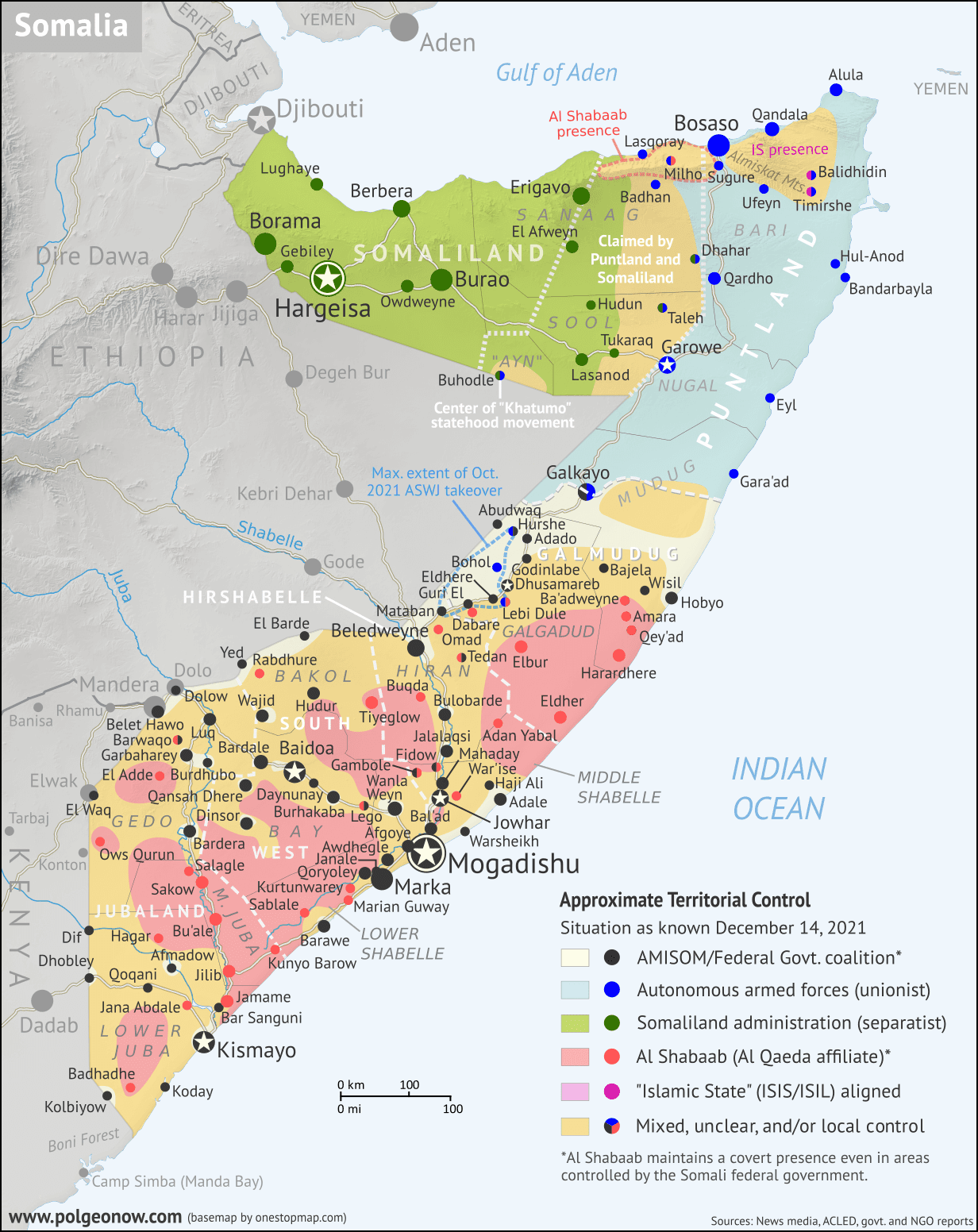
Somalia Control Map & Timeline - December 2021

There are newer versions of this map available. To see them, view all Somalia articles on PolGeoNow.

Who controls Somalia? Map (December 2021). With states, regions, and territorial control. Best Somalia control map online, thoroughly researched, detailed but concise. Shows territorial control by Federal Government of Somalia (FGS), Al Shabaab, so-called Islamic State (ISIS/ISIL), separatist Somaliland, autonomous state Puntland, and boundaries of additional federal member states Galmudug, Jubaland, South West, and Hirshabelle. Now labels state capitals and disputed boundaries between Somaliland and Puntland, as well as key towns from recent news such as Ba'adweyne, Amara, Qey'ad, Marian Guway, Balidhidhin, and more. Updated to December 14, 2021. Colorblind accessible.
Base map by Koen Adams of onestopmap.com, with territorial control by Evan Centanni and Djordje Djukic.
Contact us for permission to use this map.

(Subscribers click here to view this article in the member area)

Timeline by Evan Centanni and Djordje Djukic

Somalia Crisis Timeline: Political and Military Disarray in 2021

In the nearly 10 months since PolGeoNow's previous Somalia control map report, the country's news cycle has been dominated by a series of interconnected political crises that have led the federal government's military to the brink of civil war. All the while, the fight against Al Qaeda affiliate Al Shabaab, which operates a parallel government across much of Somalia's countryside, has continued to see a mix of victories and defeats for each side. And while the standoff between the federal army and Jubaland state forces has ended, new regional conflicts have erupted in Hirshabelle and Galmudug states, including a major resurgence of the controversial ASWJ militia.

Read on for concise summaries of the past 10 months' political crises and military trends, followed by a detailed timeline of events since February. Sources for our reporting, and for changes to the map since last time, are covered in the detailed timeline and the additional source notes at the bottom of the page.

Wednesday, October 13, 2021

Somalia v. Kenya: 3 Maps Explaining the Maritime Dispute & Court Ruling

Thumbnail image combining the three maps of the Kenya-Somalia maritime dispute, showing the two countries' overlapping territorial sea, EEZ, and continental shelf claims as well as the judgement reached in the ruling of the UN's International Court of Justice (ICJ). The full-size maps are each included separately, with full alternate text, farther down on this page.
Scroll down for the full-size maps

The UN's main court for disputes between countries, the International Court of Justice (ICJ), ruled yesterday on a contentious case many years in the making: Kenya and Somalia's dispute over the rights to a large slice of the Indian Ocean off their coasts.

While other news outlets analyze the politics and economics of the dispute, it's PolGeoNow's job to give you a clearer, more detailed explanation of its geography. And as shown in the three all-new map infographics below, that geography is a bit more complex than most news articles let on.

Scroll down to see each map at full size, along with concise explanations expanding on the information within the graphics...


Thursday, February 25, 2021

Somalia Control Map & Timeline - February 2021 (Subscription)

SUBSCRIBERS CLICK HERE TO PROCEED TO ARTICLE AND MAP

There are newer versions of this map available. To see them, view all Somalia articles on PolGeoNow.

Map by onestopmap.com, Evan Centanni, and Djordje Djukic

Subscribe for full access to all conflict map reports!

Who controls Somalia? Map (February 2021). With states, regions, and territorial control. Best Somalia control map online, thoroughly researched, detailed but concise. Shows territorial control by Federal Government of Somalia (FGS), Al Shabaab, so-called Islamic State (ISIS/ISIL), separatist Somaliland, autonomous state Puntland, and boundaries of additional federal member states Galmudug, Jubaland, South West, and Hirshabelle. Now labels state capitals and disputed boundaries between Somaliland and Puntland, as well as key towns from recent news such as Milho (Milxo), Ba'adweyne, Bur Heybe, Gobo Kibir, and more. Updated to February 24, 2021. Colorblind accessible.
In the past four months, control lines have changed little in Somalia's south, but Al Shabaab has increasingly seized villages near the northern coast, in the area disputed between Puntland and Somaliland. Meanwhile, the map has undergone a subtle overhaul, with various small adjustments made after a thorough review of available research.

See all this and more on the latest update to PolGeoNow's concise, professional Somalia control map, which includes a timeline of territorial changes and key events since our previous Somalia map report of October 2020, with sources cited.

This map and report are premium content, available to paid subscribers of the PolGeoNow Conflict Mapping Service.

Want to see before you subscribe? Check out our most recent FREE SAMPLE Somalia map!

Exclusive map report includes:

  • Up-to-date illustration of current territorial control in Somalia, color-coded for the federal government coalition (including AMISOM peacekeepers), autonomous unionist forces, separatist Somaliland, Al Qaeda affiliate Al Shabaab, and fighters aligned with the so-called "Islamic State" (IS; formerly ISIS/ISIL). Areas of mixed or unclear control indicated separately. Colorblind accessible.
  • Boundaries and labels for Somalia's official regions and states, including the self-proclaimed independent Republic of Somaliland and federal states Puntland, Galmudug, Jubaland, South West, and Hirshabelle. Illustrates the claims of both sides in the Somaliland-Puntland border dispute, as well as actual control.
  • Detailed indication of city-by-city control, including many relevant smaller towns and villages.
  • Locations of recent fighting and other important events, including Milho (Milxo), Ba'adweyne, Bur Heybe, Gobo Kibir, and more.
  • Detailed timeline of territorial control changes and key political developments since October 20, 2020, with sources cited. 
  • Summary of the conflict situation and changes to the map over the past four months.

SUBSCRIBERS CLICK HERE TO PROCEED TO ARTICLE AND MAP

Not signed up yet? Click here to learn more about our professional subscription service!
Tuesday, October 20, 2020

Somalia Control Map & Timeline - October 2020 (Subscription)

SUBSCRIBERS CLICK HERE TO PROCEED TO ARTICLE AND MAP

There are newer versions of this map available. To see them, view all Somalia articles on PolGeoNow.

Map by onestopmap.com, Evan Centanni, and Djordje Djukic

Subscribe for full access to all conflict map reports!

Who controls Somalia? Map (October 2020). With states, regions, and territorial control. Best Somalia control map online, thoroughly researched, detailed but concise. Shows territorial control by Federal Government of Somalia (FGS), Al Shabaab, so-called Islamic State (ISIS/ISIL), separatist Somaliland, autonomous state Puntland, and boundaries of additional federal member states Galmudug, Jubaland, South West, and Hirshabelle. Now labels state capitals and disputed boundaries between Somaliland and Puntland, as well as key towns from the news such as Kurtunwarey, Gendershe, Daynunay, Mubarak, Bulacle, and more. Updated to October 20, 2020. Colorblind accessible.
In the last five months, Somalia's federal government and its allies have made modest gains against Al Shabaab, capturing the first district capital in two years. Meanwhile Galmudug state, under new leadership, has become increasingly integrated with the federal-aligned military coalition.

See all this and more on the latest update to PolGeoNow's concise, professional Somalia control map, which includes a timeline of territorial changes and key events since our previous Somalia map report of May 2020, with sources cited.

This map and report are premium content, available to paid subscribers of the PolGeoNow Conflict Mapping Service.

Want to see before you subscribe? Check out our most recent FREE SAMPLE Somalia map!

Exclusive map report includes:

  • Up-to-date illustration of current territorial control in Somalia, color-coded for the federal government coalition (including AMISOM peacekeepers), autonomous unionist forces, separatist Somaliland, Al Qaeda affiliate Al Shabaab, and fighters aligned with the so-called "Islamic State" (IS; formerly ISIS/ISIL). Areas of mixed or unclear control indicated separately. Colorblind accessible.
  • Boundaries and labels for Somalia's official regions and states, including the self-proclaimed independent Republic of Somaliland and federal states Puntland, Galmudug, Jubaland, South West, and Hirshabelle. Illustrates the claims of both sides in the Somaliland-Puntland border dispute, as well as actual control.
  • Detailed indication of city-by-city control, including many relevant smaller towns and villages.
  • Locations of recent fighting and other important events, including Kurtunwarey, Gendershe, Daynunay, Mubarak, Bulacle, and more.
  • Detailed timeline of territorial control changes and key political developments since May 20, 2020, with sources cited. 
  • Summary of the conflict situation and changes to the map over the past five months.

SUBSCRIBERS CLICK HERE TO PROCEED TO ARTICLE AND MAP

Not signed up yet? Click here to learn more about our professional subscription service!

Wednesday, May 20, 2020

New & Improved: Somalia Control Map & Timeline - May 2020 (Subscription)

SUBSCRIBERS CLICK HERE TO PROCEED TO ARTICLE AND MAP

There are newer versions of this map available. To see them, view all Somalia articles on PolGeoNow.

Map by onestopmap.com, Evan Centanni, and Djordje Djukic

Subscribe for full access to all conflict map reports!

Who controls Somalia? Map (May 2020). With states, regions, and territorial control. Best Somalia control map online, thoroughly researched, detailed but concise. Shows territorial control by Federal Government of Somalia (FGS), Al Shabaab, so-called Islamic State (ISIS/ISIL), separatist Somaliland, and autonomous states Puntland and Galmudug, plus boundaries of federal states Jubaland, South West, and Hirshabelle. Now labels state capitals and disputed boundaries between Somaliland and Puntland. Updated to May 20, 2020. Colorblind accessible. Since December, Al Shabaab has lost control of some towns in Somalia, while disputes over governance in Jubaland and Galmudug states have erupted briefly into armed battles with the federal government. Meanwhile, the country is battling with a major outbreak of the COVID-19 coronavirus.

This edition of the map includes a number of improvements, including the addition of state capitals, more regional boundaries, and territorial claims by Somaliland and Puntland. City and town sizes have also been reviewed and overhauled based on better data.

See all this and more on the latest update to PolGeoNow's concise, professional Somalia control map, which includes a timeline of changes since our previous Somalia map report of December 2019, with sources cited.

This map and report are premium content, available to paid subscribers of the PolGeoNow Conflict Mapping Service.

Want to see before you subscribe? Check out our most recent FREE SAMPLE Somalia map!

Exclusive map report includes:
  • Up-to-date illustration of current territorial control in Somalia, color-coded for the federal government coalition (including AMISOM peacekeepers), autonomous unionist forces, separatist Somaliland, Al Qaeda affiliate Al Shabaab, and fighters aligned to the so-called "Islamic State" (ISIS/ISIL). Areas of mixed or unclear control indicated separately. Colorblind accessible.
  • Boundaries and labels for Somalia's official regions and states, including the autonomous administrations of Somaliland, Puntland, and Galmudug as well as the federally-supported Jubaland, South West, and Hirshabelle states. 
  • New: State capitals, more regional boundaries in north, and border claims in Puntland and Somaliland's border disputes.
  • Detailed indication of city-by-city control, including many relevant smaller towns and villages.
  • New: City and town sizes newly reviewed and overhauled based on better data.
  • Locations of recent fighting and other important events, including Janale, Lego, Belet Hawo, Dhusamareb, and more.
  • Detailed timeline of territorial control changes and key political developments since December 31, 2019, with sources cited. 
  • New: Timeline includes major events in Somalia's battle with the COVID-19 coronavirus pandemic, an important background for the political events happening in the country.
  • Summary of the conflict situation and changes to the map over the past five and a half months.

SUBSCRIBERS CLICK HERE TO PROCEED TO ARTICLE AND MAP

Not signed up yet? Click here to learn more about our professional subscription service!

Tuesday, December 31, 2019

Somalia Control Map & Timeline - December 2019 (Subscription)

SUBSCRIBERS CLICK HERE TO PROCEED TO ARTICLE AND MAP

There are newer versions of this map available. To see them, view all Somalia articles on PolGeoNow.

Map by onestopmap.com, Evan Centanni, and Djordje Djukic

Subscribe for full access to all conflict map reports!

Who controls Somalia? Map (end of 2019). With states, regions, and territorial control. Best Somalia control map online, thoroughly researched, detailed but concise. Shows territorial control by Federal Government of Somalia (FGS), Al Shabaab, so-called Islamic State (ISIS/ISIL), separatist Somaliland, and autonomous states Puntland and Galmudug, plus boundaries of federal states Jubaland, South West, and Hirshabelle. Updated to December 31, 2019. Colorblind accessible.
Since August, pro-federal forces have chipped away a bit at Al Shabaab's still-significant territory in Somalia, while disputes have raged between the federal government and the state administrations of Jubaland and Galmudug. Meanwhile, Al Shabaab claims to have captured a town in northern Somaliland.

See all this and more on the latest update to PolGeoNow's concise, professional Somalia control map, which includes a timeline of changes since our previous Somalia map report of August 2019, with sources cited.

This map and report are premium content, available to paid subscribers of the PolGeoNow Conflict Mapping Service.

Want to see before you subscribe? Check out our most recent FREE SAMPLE Somalia map!

Exclusive map report includes:
  • Up-to-date illustration of current territorial control in Somalia, color-coded for the federal government coalition (including AMISOM peacekeepers), autonomous unionist forces, separatist Somaliland, Al Qaeda affiliate Al Shabaab, and fighters aligned to the so-called "Islamic State" (ISIS/ISIL). Areas of lawlessness or unclear control indicated separately. Colorblind accessible.
  • Boundaries and labels for Somalia's official regions and states, including the autonomous administrations of Somaliland, Puntland, and Galmudug as well as the federally-supported Jubaland, South West, and Hirshabelle states.
  • Detailed indication of city-by-city control, including many relevant smaller towns and villages.
  • Locations of recent fighting and other important events, including Bal'ad, Qayib, Amara, Ga'an Marodi, and more.
  • Detailed timeline of territorial control changes and key political developments since August 13, 2019, with sources cited. 
  • Brief summary of the conflict situation and changes to the map over the past four and a half months.

SUBSCRIBERS CLICK HERE TO PROCEED TO ARTICLE AND MAP

Not signed up yet? Click here to learn more about our professional subscription service!

Thursday, November 15, 2018

Somalia Control Map & Timeline - November 2018 (Subscription)

SUBSCRIBERS CLICK HERE TO PROCEED TO ARTICLE AND MAP

There are newer versions of this map available. To see them, view all Somalia articles on PolGeoNow.

Map by onestopmap.com, Evan Centanni, and Djordje Djukic

Subscribe for full access to all conflict map reports!

Who controls Somalia? Map (2018). With states, regions, and territorial control. Best Somalia control map online, thoroughly researched, detailed but concise. Shows territorial control by Federal Government of Somalia (FGS), Al Shabaab, so-called Islamic State (ISIS/ISIL), separatist Somaliland, and autonomous states Puntland, Galmudug, and Khatumo. Updated to November 14, 2018. Colorblind accessible.
Since our last update in June, Somalia's civil war has continued at its usual pace, with both Al Qaeda affiliate Al Shabaab and the Mogadishu-based government coalition capturing towns from each other. Meanwhile, the armies of Somaliland and Puntland in the north are still facing off over their disputed border.

See all this and more on the latest update to PolGeoNow's concise, professional Somalia control map, which includes a timeline of changes since our previous Somalia map report of June 2018, with sources cited.

This map and report are premium content, available to paid subscribers of the PolGeoNow Conflict Mapping Service.

Want to see before you subscribe? Check out our most recent FREE SAMPLE Somalia map!

Exclusive map report includes:
  • Up-to-date illustration of current territorial control in Somalia, color-coded for the federal government coalition (including AMISOM peacekeepers), autonomous unionist forces, separatist Somaliland, Al Qaeda affiliate Al Shabaab, and fighters aligned to the so-called "Islamic State" (ISIS/ISIL). Areas of lawlessness or unclear control indicated separately. Colorblind accessible.
  • Boundaries and labels for Somalia's official regions, plus control lines for the autonomous administrations of Somaliland, Puntland, Galmudug, and Khatumo.
  • Detailed indication of city-by-city control, including many relevant smaller towns and villages.
  • Locations of recent fighting and other important events, including Tukaraq, Bar Sanguni, Basra, and more.
  • Detailed timeline of territorial control changes and key political developments since June 2, 2018, with sources indicated. 
  • Brief summary of the conflict situation, as well as major changes to the alignment of autonomous administrations, over the past five and a half months.

SUBSCRIBERS CLICK HERE TO PROCEED TO ARTICLE AND MAP

Not signed up yet? Click here to learn more about our professional subscription service!

Sunday, June 3, 2018

Somalia Control Map & Timeline - June 2018 (Subscription)

SUBSCRIBERS CLICK HERE TO PROCEED TO ARTICLE AND MAP

There are newer version of this map available. To see them, view all Somalia articles on PolGeoNow.

Map by onestopmap.com, Evan Centanni, and Djordje Djukic

Subscribe for full access to all conflict map reports!

Who controls Somalia? Map (2018). With states, regions, and territorial control. Best Somalia control map online, thoroughly researched and detailed but concise. Shows territorial control by Federal Government of Somalia (FGS), Al Shabaab, so-called Islamic State (ISIS/ISIL), separatist Somaliland, and autonomous states Puntland, Galmudug, and Khatumo (the ASWJ Sufi militia has merged with Galmudug state). Updated to June 2, 2018. Colorblind accessible.
In the last two months, several towns in southern Somalia have changed hands between Al Shabaab and government-allied forces, while political realignments have continued to change the country's map of autonomous states.

See all this and more on the latest update to PolGeoNow's concise, professional Somalia control map, which includes a timeline of changes since our previous Somalia map report of March 2018, with sources cited.

This map and report are premium content, available to paid subscribers of the PolGeoNow Conflict Mapping Service.

Want to see before you subscribe? Check out our most recent FREE SAMPLE Somalia map!

Exclusive map report includes:
  • Up-to-date illustration of current territorial control in Somalia, color-coded for the federal government coalition (including AMISOM peacekeepers), autonomous unionist forces, separatist Somaliland, Al Qaeda affiliate Al Shabaab, and fighters aligned to the so-called "Islamic State" (ISIS/ISIL). Areas of lawlessness or unclear control indicated separately. Colorblind accessible.
  • Boundaries and labels for Somalia's official regions, plus control lines for the autonomous administrations of Somaliland, Puntland, Galmudug, and Khatumo.
  • Detailed indication of city-by-city control, including many relevant smaller towns and villages.
  • Locations of recent fighting and other important events, including Tukaraq, Moqokori, Bulo Haji, Bali Khadar, and more.
  • Detailed timeline of territorial control changes and key political developments since March 28, 2018, with sources indicated. 
  • Brief summary of the conflict situation, as well as major changes to the alignment of autonomous administrations, over the past three months.

SUBSCRIBERS CLICK HERE TO PROCEED TO ARTICLE AND MAP

Not signed up yet? Click here to learn more about our professional subscription service!

Wednesday, March 28, 2018

Somalia Control Map & Timeline - March 2018 (Subscription)

SUBSCRIBERS CLICK HERE TO PROCEED TO ARTICLE AND MAP

There are newer versions of this map available. To see them, view all Somalia articles on PolGeoNow.

Map by onestopmap.com, Evan Centanni, and Djordje Djukic

Subscribe for full access to all conflict map reports!

Who controls Somalia? Map (2018). With states, regions, and territorial control. Best Somalia control map online, thoroughly researched and detailed but concise. Shows territorial control by Federal Government of Somalia (FGS), Al Shabaab, so-called Islamic State (ISIS/ISIL), separatist Somaliland, and autonomous states Puntland, Galmudug, Khatumo, and the ASWJ Sufi militia. Updated to March 28, 2018. Colorblind accessible.
Since last summer, Al Qaeda's Al Shabaab affiliate has lost some key towns in Somalia, but also had some victories - all this amid increasing US military involvement. Meanwhile, two pairs of rival governments farther north are moving towards unification.

See all this and more on the latest update to PolGeoNow's concise, professional Somalia control map, which includes a timeline of changes since our previous Somalia map report of August 2017, with sources cited.

This map and report are premium content, available to paid subscribers of the PolGeoNow Conflict Mapping Service.

Want to see before you subscribe? Check out our most recent FREE SAMPLE Somalia map!

Exclusive map report includes:
  • Up-to-date illustration of current territorial control in Somalia, color-coded for the federal government coalition (including AMISOM peacekeepers), autonomous unionist forces, separatist Somaliland, Al Qaeda affiliate Al Shabaab, and fighters aligned to the so-called "Islamic State" (ISIS/ISIL). Areas of lawlessness and unclear control also clearly marked. Colorblind accessible.
  • Boundaries and labels for Somalia's official regions, plus control lines for the autonomous administrations of Somaliland, Puntland, Galmudug, ASWJ, and Khatumo.
  • Detailed indication of city-by-city control, including many relevant smaller towns and villages.
  • Locations of recent fighting and other important events, including Bariire, Basra, Sablale, Torotorow, Tukaraq, and more.
  • Detailed timeline of territorial control changes and key political developments since August 25, 2017, with sources indicated. 
  • Brief summary of the conflict situation, as well as major changes to the alignment of autonomous administrations, over the past seven months.

SUBSCRIBERS CLICK HERE TO PROCEED TO ARTICLE AND MAP

Not signed up yet? Click here to learn more about our professional subscription service!