Showing posts with label original maps. Show all posts

Sunday, October 6, 2024

Israel / Palestine: Map of Control at Start of Lebanon Incursion - Oct. 6, 2024 (Subscription)

SUBSCRIBERS CLICK HERE TO VIEW FULL ARTICLE AND MAP:
Old Portal (members.polgeonow.com) | New Portal (controlmaps.polgeonow.com)


(To see more maps in this series, view all Israel articles or Palestine articles on PolGeoNow.)

Map by Evan Centanni, timeline by Djordje Djukic with Evan Centanni

Subscribe for full access to all conflict map reports!

Thumbnail preview of map of who controlled Palestine and Israel's claimed territories on October 6, 2024, soon after the beginning of Israel's ground incursion into Lebanon. Shows both Israeli and Palestinian Authority administration (Fatah and Hamas factions indicated separately). Includes bigger West Bank map (Area A, Area B, and Area C). Map also includes Gaza Strip, Golan Heights, major cities and Israeli settlements, UN peacekeeper deployments (UNIFIL in Lebanon and UNDOF in Syria), no man's land, Golan Heights buffer zone (area of separation, AOS), and Shebaa Farms. Also shows which areas of Israel proper are under the greatest military restrictions, including the so-called Gaza Envelope and Confrontation Line zones as well as much of northern Israel. Includes all major cities and various key towns and sites from the news, like Khan Yunis, Nevatim airbase, Hatzerim and Tel Nof airbases, Jabalia, Yaroun, Adeissah, Jenin, Tulkarm, Tubas, and more, as well as the so-called Philadelphi Corridor and Netzarim Corridor in the Gaza Strip. Colorblind accessible.

What some once called the "Gaza War" is now unquestionably something much bigger, with Israel directing much of its military force instead across the Lebanon border at the Hezbollah militia, assassinating enemies across the middle east, and coming under major direct attack from Iran. Ground fighting in the Gaza Strip has eased, but Israeli airstrikes continue, and Israeli military actions have intensified in the West Bank.

See all this and more in the latest update to PolGeoNow's widely-acclaimed map of territorial administration in the Israel/Palestine area. In addition to the updated map, the report also includes a detailed chronicle of changes and events since June 27, 2024, the date illustrated by our previous Israel/Palestine control map.

This map and report are premium content, available to paid subscribers of the PolGeoNow Conflict Mapping Service.

Want to see before you subscribe? Check out our most recent FREE SAMPLE Israel/Palestine map report!

Exclusive map report includes:

  • Up-to-date illustration of current territorial control across all areas claimed by either Israel or Palestine, including Hamas and Israeli military control in the Gaza Strip (not in extreme detail), as well as UN peacekeeper deployments just outside the region
  • Closer-up inset map showing the divisions in the West Bank: Israeli military control ("Area C", including Israeli settlements), Fatah-led Palestinian jurisdiction ("Area A"), zones of shared administration ("Area B"), and the (annexed) area of Israeli civilian control in East Jerusalem
  • Lines illustrating the pre-1967 ceasefire boundaries separating Israel proper from the Palestinian-claimed Gaza Strip and West Bank, as well as the Syria-claimed Golan Heights
  • Labels for contentious areas, like the Gaza Strip, West Bank, Golan Heights, Shebaa Farms, and "no man's land"
  • Illustration of which parts of Israel proper are subject to the greatest restrictions by military decree under current war powers: the "Gaza Envelope" in the south and the "Confrontation Line" in the north, and now much of northern Israel and the Golan Heights.
  • Detailed indication of city-by-city control, including key towns and other locations important to current events, including in the West Bank contested towns across the border in Lebanon
  • Locations of recent control changes and other important events, including Khan Yunis, Nevatim airbase, Hatzerim and Tel Nof airbases, Jabalia, Yaroun, Adeissah, Jenin, Tulkarm, Tubas, and more, as well as the so-called Philadelphi Corridor and Netzarim Corridor in the Gaza Strip
  • Detailed timeline of important events and changes to territorial control since June 27, 2024, with links to sources.
  • Additional timeline entries chronicling events in all four additional fronts to the conflict: (1) the Lebanon border, where Israel and Hezbollah are engaged in cross-border strikes and now an Israeli ground incursion; (2) the West Bank, where near-daily Israeli raids on Palestinian-governed cities have have recently become more intense and destructive; (3) attacks on Western shipping in the Red Sea and Gulf of Aden near Yemen, where the US and UK have retaliated militarily against the Yemeni "Houthi" government; and (4) increasing related violence across the Middle East, including direct Iranian and Houthi attacks on Israel; Israeli airstrikes and assassinations in Lebanon, Syria, and Iran; and resumed Iran-backed militia attacks on US forces in Iraq and Syria (Fronts 3 and 4 are not illustrated on the map).

SUBSCRIBERS CLICK HERE TO VIEW FULL ARTICLE AND MAP:
Old Portal (members.polgeonow.com) | New Portal (controlmaps.polgeonow.com)


Not signed up yet? Click here to learn more about our professional subscription service!

Can I purchase just this map?
This map and report are not available for automated purchase to non-subscribers. If you need access or republication rights for only this map report, contact service@polgeonow.com for options.

Saturday, June 29, 2024

Israel / Palestine: Map of Control Amid Rafah Offensive - June 27, 2024 (Subscription)

SUBSCRIBERS CLICK HERE TO VIEW FULL ARTICLE AND MAP:
Old Portal (members.polgeonow.com) | New Portal (controlmaps.polgeonow.com)


There are newer editions of this map available. To see them, view all Israel articles or Palestine articles on PolGeoNow.

Map by Evan Centanni, timeline by Djordje Djukic with Evan Centanni

Subscribe for full access to all conflict map reports!

Thumbnail preview of map of who controlled Palestine and Israel's claimed territories on June 27, 2024, during the so-called Rafah offensive. Shows both Israeli and Palestinian Authority administration (Fatah and Hamas factions indicated separately). Includes bigger West Bank map (Area A, Area B, and Area C). Map also includes Gaza Strip, Golan Heights, major cities and Israeli settlements, UN peacekeeper deployments (UNIFIL in Lebanon and UNDOF in Syria), no man's land, Golan Heights buffer zone (area of separation, AOS), and Shebaa Farms. New edition also shows so-called Gaza Envelope and Confrontation Line zones, the areas of Israel proper are under the greatest military restrictions. Includes all major cities and various key towns and sites from the news, like Rafah, Nuseirat Refugee Camp, the US floating pier (humanitarian aid pier), Mount Meron, Hebbariye, Jenin, Tulkarm, and more. Now with improved colorblind accessibility.

Over the last four months, Israel first withdrew most its forces from the Gaza Strip, soon sent them back into certain areas, then began a scaled-down version of its long-promised Rafah offensive. Its forces now hold part of Rafah and other specific areas, while the UN says there's “no authority in most of the territory”. 

Meanwhile, related violence has continued along the Lebanon border, in the West Bank, and in the Red Sea, with broader Middle East tensions reaching a peak in mid-April with a direct exchange of fire between Israel and Iran.

See all this and more in the latest update to PolGeoNow's widely-acclaimed map of territorial administration in the Israel/Palestine area. In addition to the updated map, the report also includes a detailed chronicle of changes and events since March 4, 2024, the date illustrated by our previous Israel/Palestine control map.

This map and report are premium content, available to paid subscribers of the PolGeoNow Conflict Mapping Service.

Want to see before you subscribe? Check out our most recent FREE SAMPLE Israel/Palestine map report!

Exclusive map report includes:

  • Up-to-date illustration of current territorial control across all areas claimed by either Israel or Palestine, including Hamas and Israeli military control in the Gaza Strip (not in extreme detail), as well as UN peacekeeper deployments just outside the region
  • Closer-up inset map showing the divisions in the West Bank: Israeli military control ("Area C", including Israeli settlements), Fatah-led Palestinian jurisdiction ("Area A"), zones of shared administration ("Area B"), and the (annexed) area of Israeli civilian control in East Jerusalem
  • Lines illustrating the pre-1967 ceasefire boundaries separating Israel proper from the Palestinian-claimed Gaza Strip and West Bank, as well as the Syria-claimed Golan Heights
  • Labels for contentious areas, like the Gaza Strip, West Bank, Golan Heights, Shebaa Farms, and "no man's land"
  • Illustration of which parts of Israel proper are subject to the greatest restrictions by military decree under current war powers: the "Gaza Envelope" in the south and the "Confrontation Line" in the north, as well as known closed areas of the Golan Heights
  • Detailed indication of city-by-city control, including key towns and other locations important to current events, including in the West Bank and along the border with Israel and Lebanon
  • Locations of recent control changes and other important events, including Rafah, Nuseirat Refugee Camp, the US floating humanitarian pier, Mt. Meron, Hebbariye, Jenin, Tulkarm, and more
  • Detailed timeline of important events and changes to territorial control since March 4, 2024, with links to sources.
  • Additional timeline entries chronicling events in all four additional fronts to the conflict: (1) the Lebanon border, where Israel and Hezbollah are engaged in cross-border strikes; (2) the West Bank, where near-daily Israeli raids on Palestinian-governed cities have led to intense clashes; (3) attacks on Western shipping in the Red Sea and Gulf of Aden near Yemen, where the US and UK have retaliated militarily against the Yemeni "Houthi" government; and (4) the recent flare-up of direct violence between Israeli and Iran, including Israeli strikes on Iran-aligned targets in Syria (Fronts 3 and 4 are not illustrated on the map).

SUBSCRIBERS CLICK HERE TO VIEW FULL ARTICLE AND MAP:
Old Portal (members.polgeonow.com) | New Portal (controlmaps.polgeonow.com)


Not signed up yet? Click here to learn more about our professional subscription service!

Can I purchase just this map?
This map and report are not available for automated purchase to non-subscribers. If you need access or republication rights for only this map report, contact service@polgeonow.com for options.

Tuesday, June 11, 2024

Sudan Control Map & Timeline: Former Rebels Join Fight - June 2023

Hidden image for crawlers(To see other maps in this series, view all Sudan articles on PolGeoNow.)

This marks the first fully up-to-date edition of our new Sudan map series, after several retrospective reports on the situations in previous months. The latest of those, featuring a map of control at the end of January 2024, is being published alongside this one. 

To access our full catalog of map reports covering control in Sudan and many other countries, sign up for our Control Map Subscription Service - popular with major government and international organizations, but available to individual subscribers at just US$19.99 per month!

Sudan War: Map of who controlled what in Sudan on June 11, 2024, showing the situation after most of Darfur's former rebel Joint Force joined the fight alongside the army. Best Sudan control map online, thoroughly researched for maximum accuracy. Shows territorial control by the government-affiliated Sudanese Armed Forces (SAF), the Rapid Support Forces (RSF) paramilitary, and rebel groups in Sudan including the Sudan Liberation Army/Movement's Abdelwahid El Nur faction (SLA-AW/SLM-AW) in Darfur's Jebel Marra, the SPLM-N faction of Abdelaziz El Hilu in the Two Areas of South Kordofan (Nuba Mountains) and Blue Nile. Also shows the area of control of the Ngok Dinka Abyei Area Administration (AAA) within the disputed Abyei Box, and the known bases and area of operation of the remaining Neutral Joint Force of former rebels in Darfur who haven't taken sides. Includes disputed territories claimed by other countries, including the Halaib Triangle, Bir Tawil, and Wadi Halfa Salient along the border with Egypt, plus Kafia Kingi, 14-mile, Abyei, Heglig (Hejlij), Kaka, and Bebnis along the South Sudan border, showing which parts are controlled by which country. Includes key towns and other locations from the news, including the Sennar Sugar Factory, Omdurman, Bahri, El Fau (Al Fao), Jebel Dayir, Delling (Dilling, Dalang), Zurrug, Mellit, Korma, Ayn Siro, Tina border crossing, Misteriya, Al Dabbah (El Debba), Babanusa, Lagawa (Laqawa), Um Rawaba and many more.
Map by Evan Centanni and Djordje Djukic, starting from base map by Koen Adams of onestopmap.com. "Neutral Joint Force" has been redefined to exclude Darfuri former rebel groups who have joined the fight against the RSF, now subsumed under "Govt./SAF & allies". See below for a detailed accounting of which groups are included in each territorial control category. To use this map in your own materials, please contact us to arrange permission.

Timeline by Djordje Djukic and Evan Centanni

Darfur's Joint Force Enters War Against RSF, Kicking off Battle of El Fasher

In the four months since the date depicted on PolGeoNow's previous Sudan control map, lines of control have remained mostly stable, except for a major SAF breakthrough within the city of Omdurman and the RSF's takeover of Mellit, the headquarters of Darfur's Joint Force coalition. Other changes to the map have been made to show where new evidence has emerged of RSF presence (or lack thereof), but these don't represent major victories or defeats. The bigger story has, instead, been a critical realignment in alliances.

The leaders of Darfur's most prominent "Joint Force" former rebel groups, the SLM-MM and JEM-Jibril, have been outspoken against the RSF since November 2023, even recruiting and training new SAF-allied forces in eastern Sudan. But until recently, their field commanders based in Darfur, where the core of each group's forces were stationed, had kept unofficially neutral in the war, helping preserve a year-long, citizen-mediated ceasefire in the city of El Fasher. That all changed after Joint Force troops started fighting alongside the SAF around Khartoum in late March, leading to RSF retaliation across Sudan. By mid-April, the group's major commanders in Darfur had joined the fight, kicking off a devastating, full-scale battle for the region's capital.

A few months ago, "neutral Joint Force" was a useful label for most of the former rebel forces in Darfur, but today it can only fairly apply to the minority of factions who refused to enter the battle, and now say they're launching an official "Neutral Joint Force" separate from the larger SAF-allied one. Our map has been changed accordingly, now subsuming SAF-allied groups within "Govt./SAF and allies", while reserving the "Neutral Joint Force" symbols from the January map for the new strictly neutral coalition. Nearly every Darfuri former rebel group has split into factions over the question of whether to ally with the SAF, with the longtime leaders of the SLM-TC and GSLF, alongside their loyalist factions, heading the neutral camp.

Sudan Control Map & Timeline: RSF Takes Eastern City - Jan. 2024 (Subscription)

Hidden image for crawlersSUBSCRIBERS CLICK HERE TO VIEW FULL ARTICLE AND MAP:
Old Portal (members.polgeonow.com) | New Portal (controlmaps.polgeonow.com)


There are newer editions of this map available. To see them, view all Sudan articles on PolGeoNow.

Map and article by Evan Centanni and Djordje Djukic

Subscribe for full access to all conflict map reports!

(Thumbnail preview) Sudan War: Map of who controlled what in Sudan on January 31, 2024, showing the situation after the RSF takeover of Wad Medani and most of Gezira (Jazira) state. Best Sudan control map online, thoroughly researched for maximum accuracy. Shows territorial control by the government-affiliated Sudanese Armed Forces (SAF), the Rapid Support Forces (RSF) paramilitary, and rebel groups in Sudan including the Sudan Liberation Army/Movement's Abdelwahid El Nur faction (SLA-AW/SLM-AW) in Darfur's Jebel Marra, the SPLM-N faction of Abdelaziz El Hilu in the Two Areas of South Kordofan (Nuba Mountains) and Blue Nile. Also shows the area of control of the Ngok Dinka Abyei Area Administration (AAA) within the disputed Abyei Box, and the general area of presence and major bases of the neutral Joint Force of Darfur former rebel groups. Includes disputed territories claimed by other countries, including the Halaib Triangle, Bir Tawil, and Wadi Halfa Salient along the border with Egypt, plus Kafia Kingi, 14-mile, Abyei, Heglig, Kaka, and Bebnis (Babnis) along the South Sudan border, showing which parts are controlled by which country. Includes key towns and other locations from the news, including Sennar, El Giteina (Gitaina), Al Hasaheisa, Rufaa, Bara, Habila, Nertiti, Umbro (Umm Baru), Tina border crossing, Shendi, Jebel Moon, Babanusa, Um Rawaba and many more.

In December 2024, Sudan's defiant Rapid Support Forces (RSF) paramilitary made waves by invading new parts of Sudan's eastern heartland, capturing the major city of Wad Medani and most of Gezira (Al-Jazirah) state. Meanwhile, a new battle was brewing in Darfur as tensions reached a peak in El Fasher, where our map now shows areas of control and presence for the neutral former rebel groups of the Joint Force.

(This edition of our new Sudan map series depicts control at the end of January 2024 based on research conducted through mid-June.)

See all this and more in the latest update to PolGeoNow's rigorously-researched and exhaustively cited Sudan control map and report - the most precise and accurate available online. Besides the updated map, the report also includes a brief who's-who of Sudan's rebel and former rebel groups, plus a detailed chronicle of changes and events since December 5, 2023, the date illustrated by our previous Sudan control map.

This map and report are premium content, available to paid subscribers of the PolGeoNow Control Maps Subscription Service.

Want to see before you subscribe? Check out our most recent FREE SAMPLE Sudan map report!

Exclusive map report includes:

  • Up-to-date illustration of current territorial control in Sudan's new civil war between the Sudanese Armed Forces (official government military) and Rapid Support Forces (RSF) paramilitary group, rigorously corroborated, with areas of ambiguity clearly indicated. 
  • Detailed and carefully-researched illustration of territorial control by Sudan's two major "holdout" rebel forces from before the 2023 war: SPLM-N El Hilu in South Kordofan and Blue Nile states, and the SLM-AW (SLA-AW) in Darfur's Jebel Marra. 
  • NEW: Indication of power centers and area of presence for Darfur's neutral Joint Force of former rebel groups
  • Brief who's-who guide to all the major groups and factions among Sudan's rebels and former rebels
  • Detailed explanation of what each color represents on the map, and which forces are included as "allies" of each side
  • Thoroughly-researched depictions of each disputed territory claimed by Sudan along the Egyptian and South Sudanese borders, marking which parts are controlled by the other countries and which parts by other groups (e.g. UN peacekeepers and the Ngok Dinka "Abyei Area Administration").
  • Detailed indication of city-by-city control, including key towns and other locations important to current events
  • Locations of recent control changes and other important events, including El Giteina (Gitaina), Al Hasaheisa, Rufaa, Bara, Habila, Nertiti, Umbro (Umm Baru), Tina border crossing, Shendi, Jebel Moon, Babanusa, Um Rawaba, and many more
  • Detailed timeline of important events and changes to territorial control from December 5, 2023 through January 31, 2024, with links to sources.

SUBSCRIBERS CLICK HERE TO VIEW FULL ARTICLE AND MAP:
Old Portal (members.polgeonow.com) | New Portal (controlmaps.polgeonow.com)


Not signed up yet? Click here to learn more about our professional subscription service!

Can I purchase just this map?
This map and report are not available for automated purchase to non-subscribers. If you need access or republication rights for only this map report, contact service@polgeonow.com for options.

Saturday, March 9, 2024

Israel / Palestine: Map of Control on March 4, 2024 (Subscription)

SUBSCRIBERS CLICK HERE TO VIEW FULL ARTICLE AND MAP:
Old Portal (members.polgeonow.com) | New Portal (controlmaps.polgeonow.com)


There are newer editions of this map available. To see them, view all Israel articles or Palestine articles on PolGeoNow.

Map by Evan Centanni, timeline by Djordje Djukic with Evan Centanni

Subscribe for full access to all conflict map reports!

Thumbnail preview of map of who controlled Palestine and Israel's claimed territories on March 4, 2024, four months into the Israeli (IDF) ground invasion of the Gaza Strip, and before the threatened assault on Rafah. Shows both Israeli and Palestinian Authority administration (Fatah and Hamas factions indicated separately). Includes bigger West Bank map (Area A, Area B, and Area C). Map also includes Gaza Strip, Golan Heights, major cities and Israeli settlements, UN peacekeeper deployments (UNIFIL in Lebanon and UNDOF in Syria), no man's land, Golan Heights buffer zone (area of separation, AOS), and Shebaa Farms. New edition also shows so-called Gaza Envelope and Confrontation Line zones, the areas of Israel proper are under the greatest military restrictions. Includes all major cities and various key towns and sites from the news, like Khan Yunis, Jabalia (Jabaliya), Maghazi Refugee Camp, Abasan al-Kabira, Kerem Shalom crossing, Jenin, Tulkarm, and more. Now with improved colorblind accessibility.

In the past three months, Israel's counter-invasion of the Gaza Strip has slowly ground on, with the shift focusing from Gaza City in the north to Khan Yunis in the south, and possibly to Rafah next. However, much of the Strip still remains outside of Israeli control, while closely-related violence continues at a lower level in the West Bank, on the Lebanon border, and as far afield as Yemen and Iraq.

See all this and more in the latest update to PolGeoNow's widely-acclaimed map of territorial administration in the Israel/Palestine area. In addition to the updated map, the report also includes a detailed chronicle of changes and events since December 8, 2023, the date illustrated by our previous Israel/Palestine control map.

This map and report are premium content, available to paid subscribers of the PolGeoNow Conflict Mapping Service.

Want to see before you subscribe? Check out our most recent FREE SAMPLE Israel/Palestine map report!

Exclusive map report includes:

  • Up-to-date illustration of current territorial control across all areas claimed by either Israel or Palestine, including Hamas and Israeli military control in the Gaza Strip (not in extreme detail), as well as UN peacekeeper deployments just outside the region
  • Closer-up inset map showing the divisions in the West Bank: Israeli military control (including Jewish settlements), Fatah-led Palestinian jurisdiction, areas of shared administration, and the (annexed) area of Israeli civilian control in East Jerusalem
  • Lines illustrating the pre-1967 ceasefire boundaries separating Israel proper from the Palestinian-claimed Gaza Strip and West Bank, as well as the Syria-claimed Golan Heights
  • Labels for contentious areas, like the Gaza Strip, West Bank, Golan Heights, Shebaa Farms, and "no man's land"
  • Illustration of which parts of Israel proper are subject to the greatest restrictions by military decree under current war powers: the "Gaza Envelope" in the south and the "Confrontation Line" in the north
  • Detailed indication of city-by-city control, including key towns and other locations important to current events, including in the West Bank and along the border with Israel and Lebanon
  • Locations of recent control changes and other important events, including Khan Yunis, Jabalia (Jabaliya), Maghazi Refugee Camp, Abasan al-Kabira, Kerem Shalom crossing, Jenin, Tulkarm, and more.
  • Detailed timeline of important events and changes to territorial control since December 8, 2023, with links to sources.
  • Additional timeline entries chronicling events in all four additional fronts to the conflict: (1) the Lebanon border, where Israel and Hezbollah are engaged in cross-border attacks; (2) the West Bank, where near-daily Israeli raids on Palestinian-governed cities have led to intense clashes; (3) attacks on Western shipping in the Red Sea and Gulf of Aden near Yemen, where the US and UK have retaliated militarily against the "Houthi" government; and (4) tit-for-tat attacks between Iran-backed militias and the US and Israel in Syria and Iraq (Fronts 3 and 4 are not illustrated on the map).

SUBSCRIBERS CLICK HERE TO VIEW FULL ARTICLE AND MAP:
Old Portal (members.polgeonow.com) | New Portal (controlmaps.polgeonow.com)


Not signed up yet? Click here to learn more about our professional subscription service!

Can I purchase just this map?
This map and report are not available for automated purchase to non-subscribers. If you need access or republication rights for only this map report, contact service@polgeonow.com for options.

Saturday, February 10, 2024

Sudan Control Map & Timeline: RSF Takes Darfur Cities - Dec. 2023 (Subscription)

SUBSCRIBERS CLICK HERE TO VIEW FULL ARTICLE AND MAP:
Old Portal (members.polgeonow.com) | New Portal (controlmaps.polgeonow.com)


There are newer editions of this map available. To see them, view all Sudan articles on PolGeoNow.

Map and article by Evan Centanni and Djordje Djukic

Subscribe for full access to all conflict map reports!

Sudan War: Thumbnail preview of map of who controlled what in Sudan on December 5, 2023. Best Sudan control map online, thoroughly researched for maximum accuracy. Shows territorial control by the government-affiliated Sudanese Armed Forces (SAF), the Rapid Support Forces (RSF) paramilitary group, and rebel groups in Sudan including the Sudan Liberation Army/Movement's Abdelwahid El Nur faction (SLA-AW/SLM-AW) in Darfur's Jebel Marra, the SPLM-N faction of Abdelaziz El Hilu in the Two Areas of South Kordofan (Nuba Mountains) and Blue Nile. Also shows the area of control of the Ngok Dinka Abyei Area Administration (AAA) within the disputed Abyei Box. Includes disputed territories claimed by other countries, including the Halaib Triangle, Bir Tawil, and Wadi Halfa Salient along the border with Egypt, plus Kafia Kingi, 14-mile, Abyei, Heglig, Kaka, and Bebnis along the South Sudan border, showing which parts are controlled by which country. Includes key cities and other locations from the news, including Nyala, Zalingei, Ed Daein, Ardamata, Balila oil field, Shag Omar oil field, Babanusa, Um Rawaba and many more.

From October to December of 2023, the defiant Rapid Support Forces (RSF) paramilitary group accomplished a massive consolidation of control in western Sudan's Darfur region. By early December, the country’s official military had lost its footholds in four out of five of the region's state capitals - though the RSF's control of Darfur was still not as complete as most reports implied.

(This second edition of our new Sudan map series depicts control in early December 2023, based on research conducted through January of 2024. Another edition, showing the current situation in 2024, will be coming in the near future.)

See all this and more in the latest update to PolGeoNow's rigorously-researched and exhaustively cited Sudan control map and report - the most precise and accurate available online. In addition to the updated map, the report also includes a detailed chronicle of changes and events since October 9, 2023, the date illustrated by our earlier Sudan control map.

This map and report are premium content, available to paid subscribers of the PolGeoNow Conflict Mapping Service.

Want to see before you subscribe? Check out our most recent FREE SAMPLE Sudan map report!

Exclusive map report includes:

  • Up-to-date illustration of current territorial control in Sudan's new civil war between the Sudanese Armed Forces (official government military) and Rapid Support Forces (RSF) paramilitary group, rigorously corroborated, with areas of ambiguity clearly indicated. 
  • Detailed and carefully-researched illustration of territorial control by Sudan's two major "holdout" rebel forces from before the 2023 war: SPLM-N El Hilu in South Kordofan and Blue Nile states, and the SLA-AW (SLM-AW) in Darfur's Jebel Marra.
  • Thoroughly-researched depictions of each disputed territory claimed by Sudan along the Egyptian and South Sudanese borders, marking which parts are controlled by the other countries and which parts by other groups (e.g. UN peacekeepers and the Ngok Dinka "Abyei Area Administration").
  • Detailed indication of city-by-city control, including key towns and other locations important to current events
  • Locations of recent control changes and other important events, including Nyala, Zalingei, Ed Daein, Ardamata, Balila oil field, Shag Omar oil field, Babanusa, Um Rawaba, and more.
  • Detailed timeline of important events and changes to territorial control from October 9 to December 5, 2023, with links to sources.

SUBSCRIBERS CLICK HERE TO VIEW FULL ARTICLE AND MAP:
Old Portal (members.polgeonow.com) | New Portal (controlmaps.polgeonow.com)


Not signed up yet? Click here to learn more about our professional subscription service!

Can I purchase just this map?
This map and report are not available for automated purchase to non-subscribers. If you need access or republication rights for only this map report, contact service@polgeonow.com for options.

Sudan War Control Map & Timeline - October 2023

There are later versions of this map available. To see them, view all Sudan articles on PolGeoNow.

PolGeoNow proudly presents the first edition of our new Sudan war map series, meticulously researched over many months. We believe these to be the most accurate Sudan control maps available anywhere.

This edition of the map depicts control in early October 2023, based on research conducted through January of 2024. A map of control in December 2023 has been released to our paid subscribers, and we intend to publish another free edition soon showing the current situation in 2024.

Sudan War: Map of who controlled what in Sudan on October 9, 2023. Best Sudan control map online, thoroughly researched for maximum accuracy. Shows territorial control by the government-affiliated Sudanese Armed Forces (SAF), the Rapid Support Forces (RSF) paramilitary group, and rebel groups in Sudan including the Sudan Liberation Army/Movement's Abdelwahid El Nur faction (SLA-AW/SLM-AW) in Darfur's Jebel Marra, the SPLM-N faction of Abdelaziz El Hilu in the Two Areas of South Kordofan (Nuba Mountains) and Blue Nile. Also shows the area of control of the Ngok Dinka Abyei Area Administration (AAA) within the disputed Abyei Box. Includes disputed territories claimed by other countries, including the Halaib Triangle, Bir Tawil, and Wadi Halfa Salient along the border with Egypt, as well as Kafia Kingi, 14-mile, Abyei, Heglig, Kaka, and Bebnis along the South Sudan border, showing which parts are controlled by which country. Includes key cities and other locations from the news, including Khartoum, Omdurman, El Fasher, Nyala, Geneina, Zalingei, Shag Omar oil field, Babanusa, Dibebad, Kadugli, Um Rawaba, Dilling, Bahri, Wad Rawa, Kurmuk, and many more.
Map by Evan Centanni and Djordje Djukic, starting from base map by Koen Adams of onestopmap.com. See article below for a detailed accounting of which groups are included in each territorial control category. To use this map in your own materials, please contact us to arrange permission.

Timeline by Djordje Djukic and Evan Centanni

Unknown Territory: Sudan’s New Civil War 

In April 2023, a new civil war broke out in Sudan (officially “the Sudan”)*, pitting the country’s official military, the Sudanese Armed Forces (SAF), against the Rapid Support Forces (RSF), a powerful government-affiliated paramilitary group. Sudan has fought more than one civil war before, but never in its traditional heartland along the River Nile. This new conflict is said to be the first in “at least a hundred years” where control of the capital city, Khartoum, is clearly in the balance. 

Unlike previous wars, the new conflict is essentially a power struggle among members of Sudan’s majority cultural group, the “Arab” people - and yet, analysts say it’s still a continuation of the long-running clash between the country’s central core and outer regions. The RSF’s leadership, and most of its fighters, come from the nomadic Arab communities of Sudan’s Darfur region in the west, who were integrated into Arab culture later in history than the Nile elites, and until recently held little power in the national government. (See below for further discussion of these and other conflict dynamics.)

With at least 13,000 dead as of December 2024, the war is also one of the deadliest in the world today, on par with the Myanmar conflict and only far-surpassed in 2023 by the wars in Ukraine and Israel/Palestine. Many thousands of civilians are among the dead, with the United Nations documenting indiscriminate SAF airstrikes in major cities, while also describing an apparent campaign of genocide by the RSF and allies against non-Arab citizens of West Darfur state.

Monday, December 11, 2023

Israel / Palestine: Map of Control After End of Truce (December 8, 2023)

Hidden image for crawlersThere are newer editions of this map available. To see them, view all Israel articles or Palestine articles on PolGeoNow. 

This map shows the approximate situation on December 8, a week after Israel and Hamas resumed fighting in the Gaza Strip after a seven-day "humanitarian pause".

Map of who controlled Palestine and Israel's claimed territories early on December 8, 2023, one month into the Israeli (IDF) ground invasion of the Gaza Strip, and a week after the end of the humanitarian pause (ceasefire/truce). Shows both Israeli and Palestinian Authority administration (Fatah and Hamas factions indicated separately). Includes bigger West Bank map (Area A, Area B, and Area C). Map also includes Gaza Strip, Golan Heights, major cities and Israeli settlements, UN peacekeeper deployments (UNIFIL in Lebanon and UNDOF in Syria), no man's land, Golan Heights buffer zone (area of separation, AOS), and Shebaa Farms. Now also shows Israel's closed military zones (closed military areas) and key towns and sites from the news, like Gaza City, Khan Yunis, Beit Hanoun, Jabalia, Erez Crossing, Jenin, and Kiryat Shmona (Qiryat Shemona). Now with improved colorblind accessibility.
Click to enlarge. Map by Evan Centanni, incorporating base map by Koen Adams of onestopmap.com and data from B'Tselem's interactive mapping project. (Contact us for permission to use this map.)

Timeline by Djordje Djukic, with additional reporting by Evan Centanni

Gaza Strip Divided

Just as we were publishing the previous edition of our Israel/Palestine control map, Israel began its long-expected counter-invasion into the Palestinian territory of the Gaza Strip, responding to hardline Palestinian group Hamas's unprecedented October 7 invasion of Israel. Now, one month into Israel's counter-invasion and two months into the war, the densely-populated Gaza Strip is divided between Hamas-led forces and the Israeli military. 

Israeli forces have seized large parts of Gaza City, the biggest population center in the densely-populated Strip, and completely surrounded the parts of it and nearby towns that are still under Hamas control. Meanwhile, since the temporary humanitarian ceasefire between Hamas and Israel ended a week ago, Israel has also pushed deep into the southern Gaza Strip city of Khan Yunis. For more information on control within the Gaza Strip, maps by online conflict-tracker Suriyak and ISW/Critical Threats give good detailed approximations.

Since our last report, Israel's military has appeared to confirm that it's killed at least about 5,000 Palestinian fighters and 10,000 Palestinian civilians, about ten times the respective numbers of Israeli soldiers and civilians killed by Hamas and allies in their brutal October 7 rampage through the Israeli countryside. This is roughly in line with estimates from the Hamas-affiliated Gaza Health Ministry, which as of Friday estimated a total of 17,000 Palestinians killed, about a third of them adult men (who are assumed to make up the vast majority of Hamas fighters).

Saturday, October 28, 2023

Israel / Palestine: Map of Control Before Israel's Gaza Invasion (October 27, 2023)

There are newer editions of this map available. To see them, view all Israel articles or Palestine articles on PolGeoNow.

This map shows the approximate situation early on October 27, 2023, before Israel's announced expansion of military activity within the Gaza Strip. At the time of publication, it's still unclear whether the expected Israeli ground invasion has begun, and little is known of the current situation within the Strip.

Map of who controlled Palestine and Israel's claimed territories early on October 27, 2023, before the expansion of Israeli operations in the Gaza Strip that may signal the start of the expected ground invasion. Shows both Israeli and Palestinian Authority administration (Fatah and Hamas factions indicated separately). Includes bigger West Bank map (Area A, Area B, and Area C). Map also includes Gaza Strip, Golan Heights, major cities and Israeli settlements, UN peacekeeper deployments (UNIFIL in Lebanon and UNDOF in Syria), no man's land, Golan Heights buffer zone (area of separation, AOS), and Shebaa Farms. Now also shows Israel's closed military zones (closed military areas) and key towns and sites from the news, like Sderot, Netivot, Erez Crossing, Rafah, Khan Yunis, Tulkarm, and Kiryat Shmona (Qiryat Shemona). Colorblind accessible.
Click to enlarge. Map by Evan Centanni, incorporating base map by Koen Adams of onestopmap.com and data from B'Tselem's interactive mapping project. (Contact us for permission to use this map.)

Timeline by Djordje Djukic, with additional reporting by Evan Centanni

2023 Israel-Hamas Control Map: Temporary Equilibrium

It's been almost three weeks since Palestinian group Hamas and allies burst unexpectedly out of the Gaza Strip, taking brief but unprecedented control over parts of Israel proper (see our map of the height of Hamas control). Israel's long-promised counter-invasion of the Strip may now be starting, two weeks after its military restored the lines of control to roughly the same as before the Hamas attack. But during the wait, there's been no end to violence: Israel has retaliated against Hamas with heavy bombing of that group's stronghold, the densely-populated Gaza Strip, while both Hamas in Gaza and allied Hezbollah in Lebanon have continued striking Israel with rockets and missiles launched across the borders. 

Israel reports that at least 1,400 of its people have been killed, including over 1,000 civilians - mostly in the first day of Hamas's October 7 invasion - while the Gaza Health Ministry says over 7,000 total Palestinian fighters and civilians have been killed, about 3,000 of them under the age of 18 (the ministry is part of the Hamas-dominated government of the Gaza Strip, but is generally evaluated as credible by outside observers).

Friday, October 13, 2023

Israel / Palestine Map: Height of Hamas Control in 2023 Invasion (October 7, 2023)

There are newer editions of this map available. To see them, view all Israel articles or Palestine articles on PolGeoNow.

This map shows the approximate situation on the afternoon of October 7, 2023, when control by Hamas and its allies reached farthest into Israel. Now, several days later, Israeli forces are thought to have reversed almost all those gains, returning the lines of control to roughly their same positions as just before the invasion.

Map of who controlled Palestine and Israel's claimed territories on the afternoon of October 7, 2023, at the greatest extent of penetration into Israel by the Hamas invasion. Shows both Israeli and Palestinian Authority administration (Fatah and Hamas factions indicated separately). Includes bigger West Bank map (Area A, Area B, and Area C). Map also includes Gaza Strip, Golan Heights, major cities and Israeli settlements, UN peacekeeper deployments (UNIFIL in Lebanon and UNDOF in Syria), no man's land, Golan Heights buffer zone (area of separation, AOS), and Shebaa Farms. Colorblind accessible. Also file under: Map of Hamas attack on Israel.
Click to enlarge. Map by Evan Centanni, incorporating base map by Koen Adams of onestopmap.com and data from B'Tselem's interactive mapping project. (Contact us for permission to use this map.)


Timeline by Djordje Djukic

2023 Israel-Hamas War: How much of Israel did Hamas Capture in its Invasion?

Last Saturday, just a day after the 50th anniversary of Israel's last full-scale war, the country was once again thrust into massive turmoil. In an unprecedented invasion of Israel proper, forces of hardline Palestinian party Hamas and smaller allied groups burst out of their stronghold in the Gaza Strip, briefly doubling their area of control while killing hundreds of Israeli civilians and soldiers alike. The above map shows the approximate situation at the height of Hamas and allied control, later on the same day that the invasion began.

Wednesday, October 11, 2023

Israel / Palestine Map: Who Controlled What Before the 2023 Hamas Invasion?

This article was originally published in July 2020, but has been revised and updated to October 2023. The design of the accompanying map has also been slightly revised, but there were no changes to territorial control between the previous edition and this one except for the reopening of the Gaza fishing zone.

This map shows the situation just before the current war began. For the war itself, check out our new map showing control at the height of the October 2023 Hamas invasion the next day.

Map of who controlled Palestine and Israel's claimed territories on October 6, 2023, just before Hamas's invasion and the start of the current war. Shows both Israeli and Palestinian Authority administration (Fatah and Hamas factions indicated separately). Includes bigger West Bank map (Area A, Area B, and Area C). Map also includes Gaza Strip, Golan Heights, major cities and Israeli settlements, UN peacekeeper deployments (UNIFIL in Lebanon and UNDOF in Syria), no man's land, Golan Heights buffer zone (area of separation, AOS), and Shebaa Farms. Colorblind accessible. Also file under: Palestine controlled area map, How much of Israel is Palestinian land?
Click to enlarge. Map by Evan Centanni, incorporating base map by Koen Adams of onestopmap.com and data from B'Tselem's interactive mapping project. (Contact us for permission to use this map.)

Israel and Palestine Controlled Areas: Before the War

October 2023's surprise invasion of Israel by Palestinian fighters from the Gaza Strip has catapulted the area back to the top of world headlines, and the situation on the ground is now in flux. But what exactly was the situation just before this new chapter of the conflict started? This newly-revised version of PolGeoNow's Israel/Palestine explainer article answers all your questions about who's who and what the significance of each disputed zone is. 

The accompanying map has also been slightly revised and newly fact-checked to ensure that it shows the situation accurately as of October 6, 2023, the night before the Hamas-led invasion of Israel (the only change to control is that the Gaza Strip fishing zone was apparently open for most of this year, rather than closed as it was at the time of our 2021 update).

Note that this is a map of who actually controls what, not of who claims which areas. And it's definitely not supposed to imply that any particular party should or shouldn't control any particular area. As always, PolGeoNow takes no side in these disputes, and we have done our best to report only the facts.

Monday, June 5, 2023

Which Countries Use the Euro in 2023? (Map of the Eurozone)

This map and explainer article, originally from 2016, have been updated to June 2023 to cover the recent addition of Croatia to the Eurozone. You can see previous versions of the map by viewing all Eurozone articles on PolGeoNow.

Map of the Eurozone (euro area), showing which countries use the euro as their currency. Includes members, pre-members (ERM II or ERM-2 waiting area), EU non-members using the euro, and other EU countries. Color blind accessible. Updated to June 2023 with the recent entry of Croatia into the Eurozone.
Map by Evan Centanni, from blank map by Ssolbergj. License: CC BY-SA

Article by Caleb Centanni and Staff Writer 

What is the Eurozone?

Officially called the "euro area", the Eurozone is a nickname for the group of countries in Europe that share a single currency, called the euro, as their official money. The euro currency is managed by the European Union (EU), but many countries in the EU don't use the euro, and some countries outside the EU do use it. The European Central Bank, headquartered in Frankfurt, Germany, is in charge of regulating the currency and making euro coins and bills (bank notes).

Thursday, April 20, 2023

Map: Which Countries are in the European Union in 2023, Which Aren't, and Which Want to Join?

This map and article have been revised and updated to April 2023. No new countries have joined the EU since our last update in 2020, but there are three new candidate countries and one new "potential candidate".

Map of the European Union, including all member countries, official candidate countries, and potential candidate countries, as of April 2023, updated for the recognition of Ukraine, Moldova, and Bosnia as membership candidates, and Georgia as a potential candidate (colorblind accessible). Also file under: Map of European Union Member Countries.
Map by Evan Centanni, from blank map by Ssolbergj. License: CC BY-SA

Wednesday, February 16, 2022

Mozambique Control Map: Cabo Delgado Insurgency Shifts West - February 2022 (Subscription)

SUBSCRIBERS CLICK HERE TO PROCEED TO ARTICLE AND MAP

(To see other maps in this series, view all Mozambique articles on PolGeoNow.)

Map by Evan Centanni and Djordje Djukic. Timeline by Djordje Djukic, with additional reporting by Evan Centanni

Subscribe for full access to all conflict map reports!

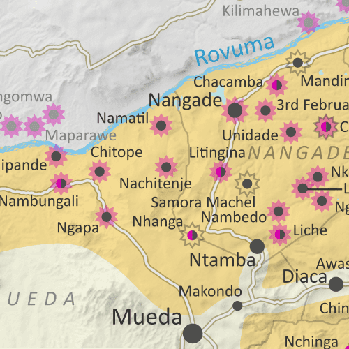
Mozambique: Cabo Delgado conflict map - February 2022: Detailed, close-up control map showing areas occupied by so-called ISIS-linked rebels in northern Mozambique (also known as Ahlu Sunnah Wa Jama, ASWJ, Ansar al-Sunnah, or Al Shabaab), plus towns and villages raided by the insurgents over the past five months (including those across the border in Tanzania. Shows major shift in insurgent activity away from Mocímboa da Praia and Palma towns, and towards Meluco and northern Mueda district, while Nangade and Macomia districts continue to be conflict hotspots.  Shows roads, rivers, and terrain, and includes key locations of the insurgency such as Naquitengue, Nachipande, Kiwengulo, Nankidunga, 5º Congresso, Nankidunga, the Total LNG site and natural gas fields, and many more towns and villages. Colorblind accessible.
After being driven from the key northeastern towns of Palma and Mocímboa da Praia by Rwandan-led forces, Mozambique's insurgents have dispersed westward as far as Meluco and Mueda districts, as well as the neighboring province of Niassa. Meanwhile, they've also increased cross-border raids into Tanzania.
 
See all this and more on the newest update to PolGeoNow's Mozambique territorial control map report, which includes a timeline of changes and important events since our previous Cabo Delgado map report at the end of last August. While the main map is focused in on Cabo Delgado province, events in Niassa province are labelled on a supplementary full-country map included in the report.

This map and report are premium content, available to paid subscribers of the PolGeoNow Conflict Mapping Service.

Want to see before you subscribe? Check out our most recent FREE SAMPLE Mozambique map!

Exclusive map report includes:

  • Detailed illustration of approximate current territorial control in Mozambique's Cabo Delgado province, color-coded for insurgents affiliated with the so-called "Islamic State" (ISIS/ISIL) vs. the Mozambican government and allies (including Rwandan and the SADC's SAMIM troops). Colorblind accessible. 
  • Detailed indication of city-by-city control status, including for many relevant smaller towns and villages.
  • Detailed indication of which towns and villages have subject to insurgent raids or pro-government military operations since the end of August 2021, including sites across the border in Tanzania.
  • Contextual details including district boundaries, rivers, major roads, and terrain.
  • Sites of international economic interest: Total's suspended LNG site, offshore natural gas fields, and Montepuez ruby mine.
  • Key locations from the news, including Ngapa, Nova Zambezia, Chitoio, Quinto Congresso, Nambungali, and many more.
  • Supplementary map showing the insurgency's location within Mozambique as a whole, also labeling towns in Niassa province that have come under attack, such as Mecula, Naulala, and Chimene.
  • Accompanying article with detailed timeline of territorial control changes and key political and military developments since late July, with sources cited. 

SUBSCRIBERS CLICK HERE TO PROCEED TO ARTICLE AND MAP

Not signed up yet? Click here to learn more about our professional subscription service!

Tuesday, January 25, 2022

Ethiopia War Map: Tigray Rebel Advance on Capital & Control Today (Nov. 2021/Jan. 2022)

(There are newer versions of this map available. To see them, view all Ethiopia articles on PolGeoNow.)

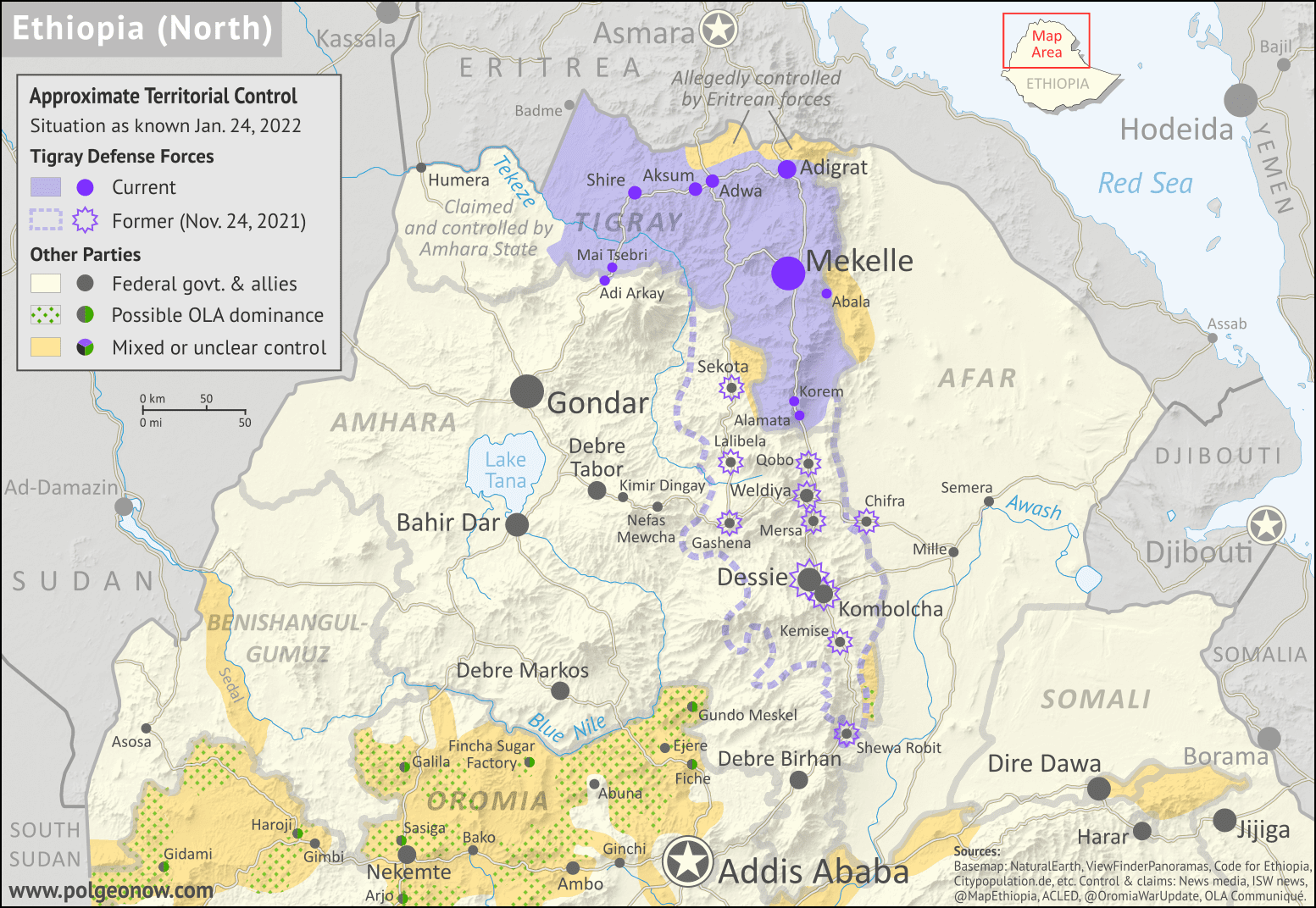
As a followup to the three Tigray war maps we've published as guest features from Daniel of Passport Party, PolGeoNow is pleased to present our new in-house map of control in Ethiopia's ongoing civil war. The new map shows Tigray rebel control both today and at its greatest extent last November, while also highlighting a second insurgency by allied rebel group the Oromo Liberation Army.

Ethiopia war map for late 2021 and early 2022, showing Tigray rebel control both at its height in November 2021, extending far down into Amhara state and near national capital Addis Ababa, and at present day (January 24, 2022). Also indicates areas claimed to be controlled by the Oromo Liberation Army in western and central Ethiopia. Colorblind accessible.
Map by Evan Centanni and Djordje Djukic. Terrain data sourced from ViewFinderPanoramas.
Contact us for permission to use this map.

(Subscribers click here to view this article in the member area)

Timeline by Djordje Djukic, with additional reporting by Evan Centanni

Rebel Advance on Addis Ababa - and Subsequent Retreat

In the five months since our previous report on Ethiopia's civil war, Tigray rebels expanded their control far south of their home state's borders, nearly reaching the national capital city of Addis Ababa. However, despite assistance from another Ethiopian rebel group, their gains were eventually reversed, with Ethiopian federal government forces and allies pushing them back within the boundaries of Tigray state. Now, the situation has almost returned to the same place it was when the war began, with Tigray largely controlled by rebels associated with its former state government, while neighboring Amhara state controls its own territory plus a section of western Tigray.

Wednesday, October 13, 2021

Somalia v. Kenya: 3 Maps Explaining the Maritime Dispute & Court Ruling

Thumbnail image combining the three maps of the Kenya-Somalia maritime dispute, showing the two countries' overlapping territorial sea, EEZ, and continental shelf claims as well as the judgement reached in the ruling of the UN's International Court of Justice (ICJ). The full-size maps are each included separately, with full alternate text, farther down on this page.
Scroll down for the full-size maps

The UN's main court for disputes between countries, the International Court of Justice (ICJ), ruled yesterday on a contentious case many years in the making: Kenya and Somalia's dispute over the rights to a large slice of the Indian Ocean off their coasts.

While other news outlets analyze the politics and economics of the dispute, it's PolGeoNow's job to give you a clearer, more detailed explanation of its geography. And as shown in the three all-new map infographics below, that geography is a bit more complex than most news articles let on.

Scroll down to see each map at full size, along with concise explanations expanding on the information within the graphics...


Tuesday, July 20, 2021

Central African Republic Control Map & Timeline - July 2021

There are newer versions of this map available. To see them, view all Central African Republic articles on PolGeoNow. 

We've revived and relaunched our coverage of territorial control in the Central African Republic, one of PolGeoNow's original areas of reporting from back in 2013. The timeline in this article covers the entire period from then up to now, and going forward, our newly-redesigned map will be updated as needed. To ensure your access to future updates, sign up for our conflict mapping service.

Central African Republic conflict: 2021 map of rebel and government control. Updated to July 16, 2021, showing territorial control by the CAR government, CPC rebel coalition (FPRC, MPC, 3R),  other ex-Séléka rebels (UPC, RPRC, MLCJ), Anti-balaka militias, and other armed groups such as Joseph Kony's Lord's Resistance Army (LRA). Colorblind accessible.
Map by Evan Centanni and Djordje Djukic. Terrain data sourced from ViewFinderPanoramas.
Contact us for permission to use this map.

(Subscribers click here to view this article in the member area)

Timeline by Djordje Djukic and Evan Centanni

Who controls the Central African Republic in 2021?

Since PolGeoNow's last coverage of rebel control in the Central African Republic back in 2013, the country's civil war has continued all the way until today, but with some major reconfigurations. The Séléka rebel coalition, officially disbanded after it took over the country's government in 2013, has undergone a long series of fragmentations and reconstitutions since stepping down from full control of the country in 2014. Perhaps more surprisingly, many of the ex-Séléka groups have teamed up with their once-bitter enemies - militias of the Anti-balaka movement - to form a unified front against the country's internationally-backed government, which sees both of them as unwelcome rogue elements.

Friday, May 14, 2021

Israel / Palestine Map: Who Controlled What in May 2021?

This is the 2021 edition of our Israel/Palestine control map, first published in July 2020. A newer version is now available.

Map of who controls Palestine and Israel's claimed territories today (May 14, 2021), as Gaza Strip violence continues to escalate? Israeli and Palestinian Authority administration (Fatah and Hamas factions indicated separately). Also file under: Palestine controlled area map. Includes bigger West Bank map (Areas A, B, C). Map also includes Gaza Strip, Golan Heights, major cities and Israeli settlements, UN peacekeeper deployments (UNIFIL and UNDOF), no man's land, Golan Heights buffer zone (area of separation, AOS), and Shebaa Farms. Colorblind accessible.
Click to enlarge. Map by Evan Centanni, incorporating base map by Koen Adams of onestopmap.com and data from B'Tselem's interactive mapping project. (Contact us for permission to use this map.)

Israel and Palestine Controlled Areas in 2021

The Israeli government's much-hyped plan to absorb parts of the Palestine-claimed West Bank into Israel in 2020 didn't happen (at least not yet). But in May 2021, the region was once again making headlines amid a new wave of fighting. So who actually controlled what parts of Palestine and Israel's claimed territories at the time? This revised version of PolGeoNow's Israel/Palestine control map lays out the details of government jurisdictions on the ground.

There were no changes to the lines of control between 2020 and this 2021 edition, but this edition of the map did feature several modifications for improved clarity and more precise depictions of the situation. If you see something you don't understand on the map, check out the latest edition of our concise outline explaining who's who and introducing each of the disputed areas.

Note that this is a map of who actually controls what, not of who claims which areas. And it's definitely not supposed to imply that any particular party should or shouldn't control any particular area. As always, PolGeoNow takes no side in these disputes, and we have done our best to report only the facts.

Newer Map and Explainer Article: Who Controls What in the Israel-Palestine conflict?