Showing posts with label rebel control. Show all posts

Sunday, July 26, 2020

Yemen Control Map & Report: Separatists Take Socotra - July 2020 (Subscription)

SUBSCRIBERS CLICK HERE TO PROCEED TO ARTICLE AND MAP

There are newer versions of this map available. To see them, view all Yemen articles on PolGeoNow.

Timeline by Djordje Djukic. Map by Evan Centanni, Djordje Djukic, and onestopmap.com
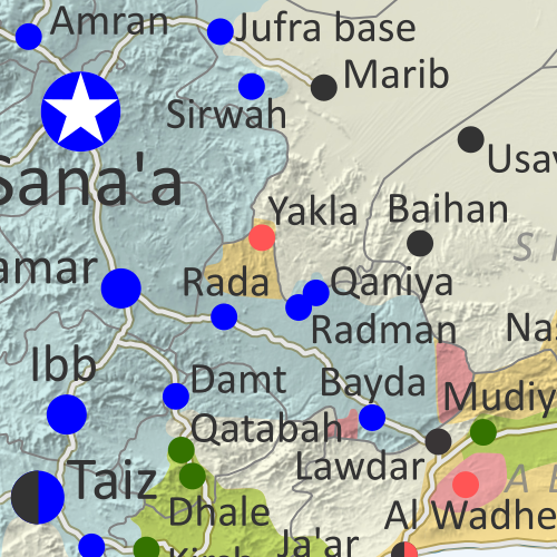
Map of what's happening in Yemen as of July 2020, including territorial control for the unrecognized Houthi government, president-in-exile Hadi and his allies in the Saudi-led coalition, the UAE-backed southern separatist Southern Transitional Council (STC), and Al Qaeda in the Arabian Peninsula (AQAP). Includes recent locations of fighting and other events, including Socotra, Qaniya, Radman, Ja'ar, Jardan, and more.
Subscribe for full access to all conflict map reports!

In the last two months, Yemen's internationally-recognized government has lost more ground to both northern Houthi forces and southern separatists, including a separatist takeover over the entire island province of Socotra.

See all this and more on the newest update to PolGeoNow's Yemen territorial control map, which includes a timeline of changes and important events since our previous Yemen map report in May.

This map and report are premium content available to paid subscribers of the PolGeoNow Conflict Mapping Service.

Want to see before you buy? Check out our most recent FREE SAMPLE Yemen map report!

Exclusive report includes:
  • Up-to-date map of current territorial control in Yemen, color-coded for the pro-Hadi coalition, the separatist Southern Transitional Council (STC), Houthi forces, and Al Qaeda in the Arabian Peninsula (AQAP)
  • Detailed indication of town-by-town control, including provincial boundaries, all major cities, and many smaller ones
  • Markers for recent areas of fighting, including Hadibu, Qaniya, Radman, Ja'ar, Jardan, and more
  • Timeline of changes to the situation since May 20, 2020, with links to sources 

SUBSCRIBERS CLICK HERE TO PROCEED TO ARTICLE AND MAP

Not a member yet? Click here to learn more about our professional subscription service!

Can I purchase just this map?
This map and report are not available for automated purchase to non-subscribers. If you need access or republication rights for only this map report, contact service@polgeonow.com for options.

Wednesday, July 1, 2020

Israel / Palestine Map: Who Controlled What in 2020?

This is the original version of PolGeoNow's Israel/Palestine administrative control map, as published in July 2020. An improved version is now available as of May 2021 (there have been no changes to the lines of control).

Who controls Palestine and Israel's claimed territories today (June 30, 2020), just before Israel's planned annexation of parts of the West Bank? Also file under: Palestine controlled area map. Includes bigger West Bank map (Areas A, B, C). Map also includes Gaza Strip, Golan Heights, major cities and Israeli settlements, UN peacekeeper deployments (UNIFIL and UNDOF), no man's land, Golan Heights buffer zone (area of separation, AOS), and Shebaa Farms. Colorblind accessible.
Click to enlarge. Map by Evan Centanni, incorporating base map by Koen Adams of onestopmap.com and data from B'Tselem's interactive mapping project. (Contact us for permission to use this map.)

The explanatory article accompanying this map has been revised and updated, and can now be found at the following link: Israel / Palestine Map: Who Controls What in May 2021?

Monday, June 22, 2020

Libyan Civil War Map & Timeline: Tables Turned in Tripoli - June 2020 (Subscription)

SUBSCRIBERS CLICK HERE TO PROCEED TO ARTICLE AND MAP

There are newer versions of this map available. To see them, view all Libya updates.

Research by Djordje Djukic. Map by onestopmap.com, Evan Centanni, and Djordje Djukic.

Subscribe for full access to all conflict map reports!

Libya: Who controls what? A concise, professional map of who controls Libya now (June 2020). Shows detailed territorial control in the Libyan Civil War as of June 21, 2020, including all major parties (Government of National Accord (GNA); Tobruk House of Representatives, General Haftar's Libyan National Army (LNA), and allies; Tuareg and Toubou (Tebu, Tubu) militias in the south; and the so-called Islamic State (ISIS/ISIL)). Includes terrain, major roads, and recent locations of interest including the Tripoli International Airport, Tarhuna, Bani Walid, Qurayyat, and more. Colorblind accessible. Over the past few weeks, the tables have turned dramatically in western Libya, with the LNA driven completely out of its footholds within the city of Tripoli, and expelled from almost the whole northwest. 

See all this and more on the latest update to PolGeoNow's concise, professional Libyan Civil War control map, which comes with a timeline of changes since our previous Libya control map report of May 29, 2020.

This map and report are premium content available to paid subscribers of the PolGeoNow Conflict Mapping Service.

Want to see before you subscribe? Check out our most recent FREE SAMPLE Libya map!

Exclusive report includes:
  • Up-to-date map of current territorial control in Libya, color-coded for the UN-backed Government of National Accord (GNA), the rival Tobruk parliament and Khalifa Haftar's Libyan National Army (LNA), the so-called "Islamic State" (ISIS/ISIL), and Toubou and Tuareg militias in the south. Colorblind accessible.
  • Detailed indication of city-by-city control, including key towns and other locations important to current events.
  • Locations of recent fighting and changes of control, including the Tripoli International Airport, Tarhuna, Bani Walid, Qurayyat, and more.
  • Detailed timeline of important events and changes to territorial control since May 29, 2020, with links to sources.

SUBSCRIBERS CLICK HERE TO PROCEED TO ARTICLE AND MAP

Not signed up yet? Click here to learn more about our professional subscription service!

Can I purchase just this map?
This map and report are not available for automated purchase to non-subscribers. If you need access or republication rights for only this map report, please contact service@polgeonow.com for options.

Friday, May 29, 2020

Libyan Civil War Map & Timeline - May 2020

There are newer versions of this map available. To see them, view all Libya updates.

This is a free edition of our Libya control map series. If you want access to our full collection of Libya maps, you can sign up for our conflict map subscription service.

Libya: Who controls what? A concise, professional map of who controls Libya now (May 2020). Shows detailed territorial control in the Libyan Civil War as of May 29, 2020, including all major parties (Government of National Accord (GNA); Tobruk House of Representatives, General Haftar's Libyan National Army (LNA), and allies; Tuareg and Toubou (Tebu, Tubu) militias in the south; and the so-called Islamic State (ISIS/ISIL)). Includes terrain, major roads, and recent locations of interest including Al-Watiyah Airbase, Tarhuna, Mizda, and more. Colorblind accessible.
Base map by Koen Adams of onestopmap.com, with territorial control by Evan Centanni and Djordje Djukic.
Contact us for permission to use this map.

(Subscribers click here to view this article in the member area)

Timeline by Djordje Djukic, with additional reporting by Evan Centanni


Mapping Control in Libya as Proxy War Escalates

Since the time of our previous Libya control map report last month, the country's UN-recognized Government of National Accord (GNA) has continued to gain ground in the west amid a major withdrawal of the rival Libyan National Army (LNA). The GNA's gains have been achieved with extensive support from Turkey, in the form of thousands of Turkish-allied Syrian rebel fighters as well as many Turkish-provided drones, in what the UN has called "the largest drone war in the world". Meanwhile, the LNA now has its own allied Syrian fighting force, brought in to support Russian private military contractors (PMCs), who are widely claimed to have the full support of Russia's government.

Friday, May 22, 2020

Yemen Control Map & Report: Separatist Conflict Expands - May 2020 (Subscription)

SUBSCRIBERS CLICK HERE TO PROCEED TO ARTICLE AND MAP

There are newer versions of this map available. To see them, view all Yemen articles on PolGeoNow.

Timeline by Djordje Djukic. Map by Evan Centanni, Djordje Djukic, and onestopmap.com

Map of what's happening in Yemen as of May 2020, including territorial control for the unrecognized Houthi government, president-in-exile Hadi and his allies in the Saudi-led coalition, the UAE-backed southern separatist Southern Transitional Council (STC), and Al Qaeda in the Arabian Peninsula (AQAP). Includes recent locations of fighting and other events, including Hadibu, al-Labanat, al-Khanjar, Balhaf, Jufra base, and more.
Subscribe for full access to all conflict map reports!

Since March, Houthi forces have continued advancing eastwards, while the conflict between the Hadi government and southern separatists has erupted into open warfare, expanding as far as the remote island province of Socotra.

See all this and more on the newest update to PolGeoNow's Yemen territorial control map, which includes a timeline of changes and important events since our previous Yemen map report in March.

This map and report are premium content available to paid subscribers of the PolGeoNow Conflict Mapping Service.

Want to see before you buy? Check out our most recent FREE SAMPLE Yemen map report!

Exclusive report includes:
  • Up-to-date map of current territorial control in Yemen, color-coded for the pro-Hadi coalition, the separatist Southern Transitional Council (STC), Houthi forces, and Al Qaeda in the Arabian Peninsula (AQAP)
  • Detailed indication of town-by-town control, including provincial boundaries, all major cities, and many smaller ones
  • Markers for recent areas of fighting, including Hadibu, al-Labanat, al-Khanjar, Balhaf, Jufra base, and more
  • Timeline of changes to the situation since March 29, 2020, with links to sources 

SUBSCRIBERS CLICK HERE TO PROCEED TO ARTICLE AND MAP

Not a member yet? Click here to learn more about our professional subscription service!

Can I purchase just this map?
This map and report are not available for automated purchase to non-subscribers. If you need access or republication rights for only this map report, contact service@polgeonow.com for options.

Wednesday, May 20, 2020

New & Improved: Somalia Control Map & Timeline - May 2020 (Subscription)

SUBSCRIBERS CLICK HERE TO PROCEED TO ARTICLE AND MAP

There are newer versions of this map available. To see them, view all Somalia articles on PolGeoNow.

Map by onestopmap.com, Evan Centanni, and Djordje Djukic

Subscribe for full access to all conflict map reports!

Who controls Somalia? Map (May 2020). With states, regions, and territorial control. Best Somalia control map online, thoroughly researched, detailed but concise. Shows territorial control by Federal Government of Somalia (FGS), Al Shabaab, so-called Islamic State (ISIS/ISIL), separatist Somaliland, and autonomous states Puntland and Galmudug, plus boundaries of federal states Jubaland, South West, and Hirshabelle. Now labels state capitals and disputed boundaries between Somaliland and Puntland. Updated to May 20, 2020. Colorblind accessible. Since December, Al Shabaab has lost control of some towns in Somalia, while disputes over governance in Jubaland and Galmudug states have erupted briefly into armed battles with the federal government. Meanwhile, the country is battling with a major outbreak of the COVID-19 coronavirus.

This edition of the map includes a number of improvements, including the addition of state capitals, more regional boundaries, and territorial claims by Somaliland and Puntland. City and town sizes have also been reviewed and overhauled based on better data.

See all this and more on the latest update to PolGeoNow's concise, professional Somalia control map, which includes a timeline of changes since our previous Somalia map report of December 2019, with sources cited.

This map and report are premium content, available to paid subscribers of the PolGeoNow Conflict Mapping Service.

Want to see before you subscribe? Check out our most recent FREE SAMPLE Somalia map!

Exclusive map report includes:
  • Up-to-date illustration of current territorial control in Somalia, color-coded for the federal government coalition (including AMISOM peacekeepers), autonomous unionist forces, separatist Somaliland, Al Qaeda affiliate Al Shabaab, and fighters aligned to the so-called "Islamic State" (ISIS/ISIL). Areas of mixed or unclear control indicated separately. Colorblind accessible.
  • Boundaries and labels for Somalia's official regions and states, including the autonomous administrations of Somaliland, Puntland, and Galmudug as well as the federally-supported Jubaland, South West, and Hirshabelle states. 
  • New: State capitals, more regional boundaries in north, and border claims in Puntland and Somaliland's border disputes.
  • Detailed indication of city-by-city control, including many relevant smaller towns and villages.
  • New: City and town sizes newly reviewed and overhauled based on better data.
  • Locations of recent fighting and other important events, including Janale, Lego, Belet Hawo, Dhusamareb, and more.
  • Detailed timeline of territorial control changes and key political developments since December 31, 2019, with sources cited. 
  • New: Timeline includes major events in Somalia's battle with the COVID-19 coronavirus pandemic, an important background for the political events happening in the country.
  • Summary of the conflict situation and changes to the map over the past five and a half months.

SUBSCRIBERS CLICK HERE TO PROCEED TO ARTICLE AND MAP

Not signed up yet? Click here to learn more about our professional subscription service!

Thursday, April 23, 2020

Libyan Civil War Map & Timeline: GNA Takes Sabratha - April 2020 (Subscription)

SUBSCRIBERS CLICK HERE TO PROCEED TO ARTICLE AND MAP

There are newer versions of this map available. To see them, view all Libya updates.

Research by Djordje Djukic. Map by onestopmap.com, Evan Centanni, and Djordje Djukic.

Subscribe for full access to all conflict map reports!

Libya: Who controls what? A concise, professional map of who controls Libya now (April 2020). Shows detailed territorial control in the Libyan Civil War as of April 22, 2020, including all major parties (Government of National Accord (GNA); Tobruk House of Representatives, General Haftar's Libyan National Army (LNA), and allies; Tuareg and Toubou (Tebu, Tubu) militias in the south; the so-called Islamic State (ISIS/ISIL); and other groups such as the National Salvation Government (NSG)). Includes terrain, major roads, and recent locations of interest including Sabratha, Aziziyah, Al-Watiyah Airbase, Waw an Namus, and more. Colorblind accessible. As the fight for Tripoli rages on, Libya's UN-recognized government has captured the city of Sabratha, securing control of the whole coastline west of the capital for the first time in a year.

See all this and more on the latest update to PolGeoNow's concise, professional Libyan Civil War control map, which comes with a timeline of changes since our previous Libya control map report of January 26, 2020.

This map and report are premium content available to paid subscribers of the PolGeoNow Conflict Mapping Service.

Want to see before you subscribe? Check out our most recent FREE SAMPLE Libya map!

Exclusive report includes:
  • Up-to-date map of current territorial control in Libya, color-coded for the UN-backed Government of National Accord (GNA), the rival Tobruk parliament and Khalifa Haftar's Libyan National Army (LNA), the so-called "Islamic State" (ISIS/ISIL), and Toubou and Tuareg militias in the south. Colorblind accessible.
  • Detailed indication of city-by-city control, including key towns and other locations important to current events.
  • Locations of recent fighting and changes of control, including Sabratha, Aziziyah, Al-Watiyah Airbase, Waw an Namus, and more.
  • Detailed timeline of important events and changes to territorial control since January 26, 2020, with links to sources.

SUBSCRIBERS CLICK HERE TO PROCEED TO ARTICLE AND MAP

Not signed up yet? Click here to learn more about our professional subscription service!

Can I purchase just this map?
This map and report are not available for automated purchase to non-subscribers. If you need access or republication rights for only this map report, please contact service@polgeonow.com for options.

Sunday, March 29, 2020

Yemen Control Map & Report: Houthis Make Key Gains - March 2020 (Subscription)

SUBSCRIBERS CLICK HERE TO PROCEED TO ARTICLE AND MAP

There are newer versions of this map available. To see them, view all Yemen articles on PolGeoNow.

Timeline by Djordje Djukic. Map by Evan Centanni, Djordje Djukic, and onestopmap.com

Map of what's happening in Yemen as of March 2020, including territorial control for the unrecognized Houthi government, president-in-exile Hadi and his allies in the Saudi-led coalition, the UAE-backed southern separatist Southern Transitional Council (STC), and Al Qaeda in the Arabian Peninsula (AQAP). Includes recent locations of fighting and other events, such as Al-Hazm, Yatmah, Shahan, Durayhimi, al-Labanat base, and more.
Subscribe for full access to all conflict map reports!

Since February, Houthi forces have expanded their control in northern Yemen, putting the internationally-backed Hadi government on the defensive, even as the conflict between Hadi and formerly-allied separatists simmers on in the south.

See all this and more on the newest update to PolGeoNow's Yemen territorial control map, which includes a timeline of changes and important events since our previous Yemen map report in February.

This map and report are premium content available to paid subscribers of the PolGeoNow Conflict Mapping Service.

Want to see before you buy? Check out our most recent FREE SAMPLE Yemen map report!

Exclusive report includes:
  • Up-to-date map of current territorial control in Yemen, color-coded for the pro-Hadi coalition, the separatist Southern Transitional Council (STC), Houthi forces, and Al Qaeda in the Arabian Peninsula (AQAP).
  • Detailed indication of town-by-town control, including provincial boundaries, all major cities, and many smaller ones
  • Markers for recent areas of fighting, including Al-Hazm, Yatmah, Shahan, Durayhimi, and more
  • Timeline of changes to the situation since February 16, 2020, with links to sources 

SUBSCRIBERS CLICK HERE TO PROCEED TO ARTICLE AND MAP

Not a member yet? Click here to learn more about our professional subscription service!

Can I purchase just this map?
This map and report are not available for automated purchase to non-subscribers. If you need access or republication rights for only this map report, contact service@polgeonow.com for options.

Sunday, March 22, 2020

Syrian Civil War Map & Timeline: New Ceasefire Lines in Northwest - March 2020 (Subscription)

SUBSCRIBERS CLICK HERE TO PROCEED TO ARTICLE AND MAP

There are newer versions of this map available. To see them, view all Syria updates.

Research by Djordje Djukic. Map by onestopmap.com, Evan Centanni, and Djordje Djukic

Subscribe for full access to all conflict map reports!

Map of Syrian Civil War (Syria control map): Territorial control in Syria in March 2020 (Free Syrian Army rebels, Kurdish YPG, Syrian Democratic Forces (SDF), Hayat Tahrir al-Sham (HTS / Al-Nusra Front), Islamic State (ISIS/ISIL), and others). Includes Turkish/TFSA control, joint SDF-Assad control, US deconfliction zone, and Turkey-Russia security corridor, plus recent locations of conflict and territorial control changes, including Kafr Nabl, Nayrab, Anadan, Al Sanamayn, and more. Colorblind accessible. Since last month, Syria's Assad government has gained more ground against the rebels and come into direct conflict with the Turkish military. Now, a deal between Russia and Turkey has brought a new ceasefire to the area.

See all this and more on the latest update to PolGeoNow's concise, professional Syrian Civil War control map, which includes a timeline of changes since our previous Syria map report in February, with sources cited.

This map and report are premium content, available to paid subscribers of the PolGeoNow Conflict Mapping Service.

Want to see before you subscribe? Check out our most recent FREE SAMPLE Syria map!

Exclusive map report includes:
  • Up-to-date illustration of current territorial control in Syria, color-coded for the Assad government, rebel groups, "Islamic State" (ISIS/ISIL) fighters, and the Kurdish-led Syrian Democratic Forces (SDF). Colorblind accessible.
  • Special symbols for joint Turkish/rebel control and joint SDF/government control in the border region
  • Extent of "security corridor" sponsored by Turkey and Russia in the rebel-held northwest
  • Outline showing approximate location of the one publicly-known US "deconfliction zone"
  • Special symbols indicating towns dominated by rebels of the former Al Qaeda Nusra Front (now Hayat Tahrir al-Sham or HTS) and by the Kurdish YPG militia (part of the SDF anti-IS coalition)
  • Detailed indication of city-by-city control, including key towns and other locations important to current events
  • Locations of recent control changes and other important events, including Kafr Nabl, Nayrab, Anadan, Al Sanamayn, and more
  • Detailed timeline of important events and changes to territorial control since February 14, 2020, compiled by our Syria-Iraq expert, with links to sources.

SUBSCRIBERS CLICK HERE TO PROCEED TO ARTICLE AND MAP

Not signed up yet? Click here to learn more about our professional subscription service!

Can I purchase just this map?
This map and report are not available for automated purchase to non-subscribers. If you need access or republication rights for only this map report, contact service@polgeonow.com for options.

Monday, February 17, 2020

Yemen Control Map & Report - February 2020 (Subscription)

SUBSCRIBERS CLICK HERE TO PROCEED TO ARTICLE AND MAP

There are newer versions of this map available. To see them, view all Yemen articles on PolGeoNow.

Timeline by Djordje Djukic. Map by Evan Centanni, Djordje Djukic, and onestopmap.com

Map of what is happening in Yemen as of February 2020, including territorial control for the unrecognized Houthi government, president-in-exile Hadi and his allies in the Saudi-led coalition, the UAE-backed southern separatist Southern Transitional Council (STC), and Al Qaeda in the Arabian Peninsula (AQAP). Includes recent locations of fighting and other events, such as Nihm, Majzar, Yakla, and more.
Subscribe for full access to all conflict map reports!

Over the past two months, the Houthi government has gained some ground in central Yemen against the internationally-backed government of President Hadi, and separatists still hold key towns in the south despite shrinking estimates of their total control.

See all this and more on the newest update to PolGeoNow's Yemen territorial control map, which includes a timeline of changes and important events since our previous Yemen map report in December.

This map and report are premium content available to paid subscribers of the PolGeoNow Conflict Mapping Service.

Want to see before you buy? Check out our most recent FREE SAMPLE Yemen map report!

Exclusive report includes:
  • Up-to-date map of current territorial control in Yemen, color-coded for the pro-Hadi coalition, the separatist Southern Transitional Council (STC), Houthi forces, and Al Qaeda in the Arabian Peninsula (AQAP).
  • Detailed indication of town-by-town control, including provincial boundaries, all major cities, and many smaller ones
  • Markers for recent areas of fighting, including Nihm, Majzar, Yakla, and more
  • Timeline of changes to the situation since December 15, 2019, with links to sources 

SUBSCRIBERS CLICK HERE TO PROCEED TO ARTICLE AND MAP

Not a member yet? Click here to learn more about our professional subscription service!

Can I purchase just this map?
This map and report are not available for automated purchase to non-subscribers. If you need access or republication rights for only this map report, contact service@polgeonow.com for options.

Friday, February 14, 2020

Syrian Civil War Map & Timeline: Assad Retakes Key Highway - February 2020 (Subscription)

SUBSCRIBERS CLICK HERE TO PROCEED TO ARTICLE AND MAP

There are newer versions of this map available. To see them, view all Syria updates.

Research by Djordje Djukic. Map by onestopmap.com, Evan Centanni, and Djordje Djukic

Subscribe for full access to all conflict map reports!

Map of Syrian Civil War (Syria control map): Territorial control in Syria in February 2020 (Free Syrian Army rebels, Kurdish YPG, Syrian Democratic Forces (SDF), Hayat Tahrir al-Sham (HTS / Al-Nusra Front), Islamic State (ISIS/ISIL), and others). Includes Turkish/TFSA control, joint SDF-Assad control, US deconfliction zone, and Turkey-Russia demilitarized buffer zone, plus recent locations of conflict and territorial control changes, including Marat al-Numan, Saraqeb, Regiment 46, Al-Eiss, and more. Colorblind accessible. Over the past month, forces loyal to Syria's Assad government have many major gains in the northwest, capturing two rebel strongholds and reestablishing control along the entire Damascus-Aleppo highway for the first time in eight years.

 See all this and more on the latest update to PolGeoNow's concise, professional Syrian Civil War control map, which includes a timeline of changes since our previous Syria map report in January, with sources cited.

This map and report are premium content, available to paid subscribers of the PolGeoNow Conflict Mapping Service.

Want to see before you subscribe? Check out our most recent FREE SAMPLE Syria map!

Exclusive map report includes:
  • Up-to-date illustration of current territorial control in Syria, color-coded for the Assad government, rebel groups, "Islamic State" (ISIS/ISIL) fighters, and the Kurdish-led Syrian Democratic Forces (SDF). Colorblind accessible.
  • Special symbols for joint Turkish/rebel control and joint SDF/government control in the border region
  • Extent of "buffer zone" sponsored by Turkey and Russia in the rebel-held northwest
  • Outline showing approximate location of the one publicly-known US "deconfliction zone"
  • Special symbols indicating towns dominated by rebels of the former Al Qaeda Nusra Front (now Hayat Tahrir al-Sham or HTS) and by the Kurdish YPG militia (part of the SDF anti-IS coalition)
  • Detailed indication of city-by-city control, including key towns and other locations important to current events
  • Locations of recent control changes and other important events, including Marat al-Numan, Saraqeb, the Regiment 46 base, Al-Eiss, and more
  • Detailed timeline of important events and changes to territorial control since January 20, 2020, compiled by our Syria-Iraq expert, with links to sources.

SUBSCRIBERS CLICK HERE TO PROCEED TO ARTICLE AND MAP

Not signed up yet? Click here to learn more about our professional subscription service!

Can I purchase just this map?
This map and report are not available for automated purchase to non-subscribers. If you need access or republication rights for only this map report, contact service@polgeonow.com for options.

Monday, January 27, 2020

Libyan Civil War Map & Timeline: LNA Takes Sirte - January 2020 (Subscription)

SUBSCRIBERS CLICK HERE TO PROCEED TO ARTICLE AND MAP

There are newer versions of this map available. To see them, view all Libya updates.

Research by Djordje Djukic. Map by onestopmap.com, Evan Centanni, and Djordje Djukic.

Subscribe for full access to all conflict map reports!

Libya: Who controls what? A concise, professional map of who controls Libya now (December 2019). Shows detailed territorial control in the Libyan Civil War as of January 26, 2020, including all major parties (Government of National Accord (GNA); Tobruk House of Representatives, General Haftar's Libyan National Army (LNA), and allies; Tuareg and Toubou (Tebu, Tubu) militias in the south; the so-called Islamic State (ISIS/ISIL); and other groups such as the National Salvation Government (NSG)). Includes terrain, major roads, and recent locations of interest including Sirte, Yarmouk Camp, Abu Grain, and more. Colorblind accessible. Since a month ago, the eastern-based Libyan National Army has captured the coastal town of Sirte and reached the doorstep of western-controlled capital Tripoli, even as the western government welcomes reinforcements from the Turkish military and allied Syrian rebels.

See all this and more on the latest update to PolGeoNow's concise, professional Libyan Civil War control map, which comes with a timeline of changes since our previous Libya control map report of December 27, 2019.

This map and report are premium content available to paid subscribers of the PolGeoNow Conflict Mapping Service.

Want to see before you subscribe? Check out our most recent FREE SAMPLE Libya map!

Exclusive report includes:
  • Up-to-date map of current territorial control in Libya, color-coded for the UN-backed Government of National Accord (GNA), the rival Tobruk parliament and Khalifa Haftar's Libyan National Army (LNA), the so-called "Islamic State" (ISIS/ISIL), and Toubou and Tuareg militias in the south. Colorblind accessible.
  • Detailed indication of city-by-city control, including key towns and other locations important to current events.
  • Locations of recent fighting and changes of control, including Sirte, Yarmouk Camp, Abu Grain, and more.
  • Detailed timeline of important events and changes to territorial control since December 27, 2019, with links to sources.

SUBSCRIBERS CLICK HERE TO PROCEED TO ARTICLE AND MAP

Not signed up yet? Click here to learn more about our professional subscription service!

Can I purchase just this map?
This map and report are not available for automated purchase to non-subscribers. If you need access or republication rights for only this map report, please contact service@polgeonow.com for options.

Wednesday, January 22, 2020

Syrian Civil War Map & Timeline - January 2020 (Subscription)

SUBSCRIBERS CLICK HERE TO PROCEED TO ARTICLE AND MAP

There are newer versions of this map available. To see them, view all Syria updates.

Research by Djordje Djukic. Map by onestopmap.com, Evan Centanni, and Djordje Djukic

Subscribe for full access to all conflict map reports!

Map of Syrian Civil War (Syria control map): Territorial control in Syria in January 2020 (Free Syrian Army rebels, Kurdish YPG, Syrian Democratic Forces (SDF), Hayat Tahrir al-Sham (HTS / Al-Nusra Front), Islamic State (ISIS/ISIL), and others). Includes Turkish/TFSA control, joint SDF-Assad control, US deconfliction zone, and Turkey-Russia demilitarized buffer zone, plus recent locations of conflict and territorial control changes, including Marat al-Numan, Al-Hayl Gas Field, Abu Kamal, and more. Colorblind accessible.Since November, Syrian army forces loyal to the Bashar al-Assad government have captured more small parts of the rebel-dominated Idlib province, even as the so-called "Islamic State" (ISIS/ISIL) continues its activities in the eastern desert.

See all this and more on the latest update to PolGeoNow's concise, professional Syrian Civil War control map, which includes a timeline of changes since our previous Syria map report in November, with sources cited.

This map and report are premium content, available to paid subscribers of the PolGeoNow Conflict Mapping Service.

Want to see before you subscribe? Check out our most recent FREE SAMPLE Syria map!

Exclusive map report includes:
  • Up-to-date illustration of current territorial control in Syria, color-coded for the Assad government, rebel groups, "Islamic State" (ISIS/ISIL) fighters, and the Kurdish-led Syrian Democratic Forces (SDF). Colorblind accessible.
  • Special symbols for joint Turkish/rebel control and joint SDF/government control in the border region
  • Extent of "buffer zone" sponsored by Turkey and Russia in the rebel-held northwest
  • Outline showing approximate location of the one publicly-known US "deconfliction zone"
  • Special symbols indicating towns dominated by rebels of the former Al Qaeda Nusra Front (now Hayat Tahrir al-Sham or HTS) and by the Kurdish YPG militia (part of the SDF anti-IS coalition).
  • Detailed indication of city-by-city control, including key towns and other locations important to current events.
  • Locations of recent control changes and other important events, including Ras al-Ayn, Tel Abyad, Ayn Issa, and more.
  • Detailed timeline of important events and changes to territorial control since November 28, 2019, compiled by our Syria-Iraq expert, with links to sources. 

SUBSCRIBERS CLICK HERE TO PROCEED TO ARTICLE AND MAP

Not signed up yet? Click here to learn more about our professional subscription service!

Can I purchase just this map?
This map and report are not available for automated purchase to non-subscribers. If you need access or republication rights for only this map report, contact service@polgeonow.com for options.

Saturday, January 11, 2020

Iraq Control Map & Timeline - January 2020

There are newer versions of this map available. To see them, view all Iraq updates.

Iraq Control Map 2020, updated to January 10. Shows areas of Iraq under ISIS control (Islamic State/ISIL/Daesh), and under the control of the Baghdad government, the Kurdistan Peshmerga, and the Yezidi Sinjar Alliance (YBS and YJE). Colorblind accessible.
Basemap by Koen Adams of onestopmap.com, with territorial control by Evan Centanni and Djordje Djukic.
Contact us for permission to use this map.
(Subscribers click here to view this article in the member area)

Timeline by Djordje Djukic, with additional reporting by Evan Centanni

Iraq Map: Who Controls What in 2020

In the nearly two years since our previous Iraq control map update, there have been few major changes to the situation on the ground. But the so-called "Islamic State" (IS; formerly ISIS/ISIL) isn't gone, and recent reports say the group has begun regaining power in the country's north. Tensions have also escalated recently between the US and Iran - both countries are heavily involved in Iraq, and have long competed for influence there. Meanwhile, the self-governed Kurdistan region remains in control of the far north, despite having lost some its claimed territory to the Iraqi central government in the aftermath of its controversial 2017 independence vote.

Tuesday, December 31, 2019

Somalia Control Map & Timeline - December 2019 (Subscription)

SUBSCRIBERS CLICK HERE TO PROCEED TO ARTICLE AND MAP

There are newer versions of this map available. To see them, view all Somalia articles on PolGeoNow.

Map by onestopmap.com, Evan Centanni, and Djordje Djukic

Subscribe for full access to all conflict map reports!

Who controls Somalia? Map (end of 2019). With states, regions, and territorial control. Best Somalia control map online, thoroughly researched, detailed but concise. Shows territorial control by Federal Government of Somalia (FGS), Al Shabaab, so-called Islamic State (ISIS/ISIL), separatist Somaliland, and autonomous states Puntland and Galmudug, plus boundaries of federal states Jubaland, South West, and Hirshabelle. Updated to December 31, 2019. Colorblind accessible.
Since August, pro-federal forces have chipped away a bit at Al Shabaab's still-significant territory in Somalia, while disputes have raged between the federal government and the state administrations of Jubaland and Galmudug. Meanwhile, Al Shabaab claims to have captured a town in northern Somaliland.

See all this and more on the latest update to PolGeoNow's concise, professional Somalia control map, which includes a timeline of changes since our previous Somalia map report of August 2019, with sources cited.

This map and report are premium content, available to paid subscribers of the PolGeoNow Conflict Mapping Service.

Want to see before you subscribe? Check out our most recent FREE SAMPLE Somalia map!

Exclusive map report includes:
  • Up-to-date illustration of current territorial control in Somalia, color-coded for the federal government coalition (including AMISOM peacekeepers), autonomous unionist forces, separatist Somaliland, Al Qaeda affiliate Al Shabaab, and fighters aligned to the so-called "Islamic State" (ISIS/ISIL). Areas of lawlessness or unclear control indicated separately. Colorblind accessible.
  • Boundaries and labels for Somalia's official regions and states, including the autonomous administrations of Somaliland, Puntland, and Galmudug as well as the federally-supported Jubaland, South West, and Hirshabelle states.
  • Detailed indication of city-by-city control, including many relevant smaller towns and villages.
  • Locations of recent fighting and other important events, including Bal'ad, Qayib, Amara, Ga'an Marodi, and more.
  • Detailed timeline of territorial control changes and key political developments since August 13, 2019, with sources cited. 
  • Brief summary of the conflict situation and changes to the map over the past four and a half months.

SUBSCRIBERS CLICK HERE TO PROCEED TO ARTICLE AND MAP

Not signed up yet? Click here to learn more about our professional subscription service!

Saturday, December 28, 2019

Libyan Civil War Map & Timeline - December 2019 (Subscription)

SUBSCRIBERS CLICK HERE TO PROCEED TO ARTICLE AND MAP

There are newer versions of this map available. To see them, view all Libya updates.

Research by Djordje Djukic. Map by onestopmap.com, Evan Centanni, and Djordje Djukic.

Subscribe for full access to all conflict map reports!

Libya: Who controls what? A concise, professional map of who controls Libya now (December 2019). Shows detailed territorial control in the Libyan Civil War as of September 27, 2019, including all major parties (Government of National Accord (GNA); Tobruk House of Representatives, General Haftar's Libyan National Army (LNA), and allies; Tuareg and Toubou (Tebu, Tubu) militias in the south; the so-called Islamic State (ISIS/ISIL); and other groups such as the National Salvation Government (NSG)). Includes terrain, major roads, and recent locations of interest including Yarmouk Camp, Tripoli International Airport, El Feel Oilfield, Tummo border crossing, and more. Colorblind accessible. Since November, forces loyal to Libya's eastern-based government have moved closer to Tripoli's center, where they hope to unseat the country's rival western-based government, even as Turkey prepares a military intervention to defend the government in Tripoli.

See all this and more on the latest update to PolGeoNow's concise, professional Libyan Civil War control map, which comes with a timeline of changes since our previous Libya control map report of November 19, 2019.

This map and report are premium content available to paid subscribers of the PolGeoNow Conflict Mapping Service.

Want to see before you subscribe? Check out our most recent FREE SAMPLE Libya map!

Exclusive report includes:
  • Up-to-date map of current territorial control in Libya, color-coded for the UN-backed Government of National Accord (GNA), the rival Tobruk parliament and Khalifa Haftar's Libyan National Army (LNA), the so-called "Islamic State" (ISIS/ISIL), and Toubou and Tuareg militias in the south. Colorblind accessible.
  • Detailed indication of city-by-city control, including key towns and other locations important to current events.
  • Locations of recent fighting and changes of control, including Yarmouk Camp, Tripoli International Airport, El Feel Oilfield, Tummo border crossing, and more.
  • Detailed timeline of important events and changes to territorial control since November 19, 2019, with links to sources.

SUBSCRIBERS CLICK HERE TO PROCEED TO ARTICLE AND MAP

Not signed up yet? Click here to learn more about our professional subscription service!

Can I purchase just this map?
This map and report are not available for automated purchase to non-subscribers. If you need access or republication rights for only this map report, please contact service@polgeonow.com for options.

Monday, December 16, 2019

Yemen Control Map & Report - December 2019 (Subscription)

SUBSCRIBERS CLICK HERE TO PROCEED TO ARTICLE AND MAP

There are newer versions of this map available. To see them, view all Yemen articles on PolGeoNow.

Timeline by Djordje Djukic. Map by Evan Centanni, Djordje Djukic, and onestopmap.com

Map of what is happening in Yemen as of December 15, 2019, including territorial control for the unrecognized Houthi government, president-in-exile Hadi and his allies in the Saudi-led coalition, the UAE-backed southern separatist Southern Transitional Council (STC), and Al Qaeda in the Arabian Peninsula (AQAP). Includes recent locations of fighting and other events, including Ahwar, Baqim, Malahith, and more.
Subscribe for full access to all conflict map reports!

Over the past two months, separatists seeking an independent South Yemen have held onto control of port city Aden and other towns, despite attempts at reconciliation with the Saudi-backed government of President Hadi. Meanwhile, the rival Houthi government still controls much of the country.

See all this and more on the newest update to PolGeoNow's Yemen territorial control map, which includes a timeline of changes and important events since our previous Yemen map report in October.

This map and report are premium content available to paid subscribers of the PolGeoNow Conflict Mapping Service.

Want to see before you buy? Check out our most recent FREE SAMPLE Yemen map report!

Exclusive report includes:
  • Up-to-date map of current territorial control in Yemen, color-coded for the pro-Hadi coalition, the separatist Southern Transitional Council (STC), Houthi forces, and Al Qaeda in the Arabian Peninsula (AQAP).
  • Detailed indication of town-by-town control, including provincial boundaries, all major cities, and many smaller ones
  • Markers for recent areas of fighting, including Ahwar, Baqim, Malahith, and more
  • Timeline of changes to the situation since October 12, 2019, with links to sources 

SUBSCRIBERS CLICK HERE TO PROCEED TO ARTICLE AND MAP

Not a member yet? Click here to learn more about our professional subscription service!

Can I purchase just this map?
This map and report are not available for automated purchase to non-subscribers. If you need access or republication rights for only this map report, contact service@polgeonow.com for options.

Saturday, November 30, 2019

Syrian Civil War Map & Timeline - November 2019 (Subscription)

SUBSCRIBERS CLICK HERE TO PROCEED TO ARTICLE AND MAP

There are newer versions of this map available. To see them, view all Syria updates.

Research by Djordje Djukic. Map by onestopmap.com, Evan Centanni, and Djordje Djukic

Subscribe for full access to all conflict map reports!

Map of Syrian Civil War (Syria control map): Territorial control in Syria in November 2019 (Free Syrian Army rebels, Kurdish YPG, Syrian Democratic Forces (SDF), Hayat Tahrir al-Sham (HTS / Al-Nusra Front), Islamic State (ISIS/ISIL), and others). Includes Turkish/TFSA control, joint SDF-Assad control, US deconfliction zone, and Turkey-Russia demilitarized buffer zone, plus recent locations of conflict and territorial control changes, including Ras al-Ayn, Tel Abyad, Ayn Issa, and more. Colorblind accessible. In the past month, Turkey and its allies have further consolidated their chunk of territory in northern Syria, while the Assad-loyal Syrian military has deployed along most of the rest of the border, in line with the Russia-brokered agreement for a "safe zone" free of Kurdish militia fighters.

See all this and more on the latest update to PolGeoNow's concise, professional Syrian Civil War control map, which includes a timeline of changes since our previous Syria map report in October, with sources cited.

This map and report are premium content, available to paid subscribers of the PolGeoNow Conflict Mapping Service.

Want to see before you subscribe? Check out our most recent FREE SAMPLE Syria map!

Exclusive map report includes:
  • NEW: Special symbols for joint Turkish/rebel control and joint SDF/government control, so you can track Turkey's intervention in the border region
  • Up-to-date illustration of current territorial control in Syria, color-coded for the Assad government, rebel groups, "Islamic State" (ISIS/ISIL) fighters, and the Kurdish-led Syrian Democratic Forces (SDF). Colorblind accessible.
  • Extent of "buffer zone" sponsored by Turkey and Russia in the rebel-held northwest
  • Outline showing approximate location of the one publicly-known US "deconfliction zone"
  • Special symbols indicating towns dominated by rebels of the former Al Qaeda Nusra Front (now Hayat Tahrir al-Sham or HTS) and by the Kurdish YPG militia (part of the SDF anti-IS coalition).
  • Detailed indication of city-by-city control, including key towns and other locations important to current events.
  • Locations of recent control changes and other important events, including Ras al-Ayn, Tel Abyad, Ayn Issa, and more.
  • Detailed timeline of important events and changes to territorial control since October 27, 2019, compiled by our Syria-Iraq expert, with links to sources. 

SUBSCRIBERS CLICK HERE TO PROCEED TO ARTICLE AND MAP

Not signed up yet? Click here to learn more about our professional subscription service!

Can I purchase just this map?
This map and report are not available for automated purchase to non-subscribers. If you need access or republication rights for only this map report, contact service@polgeonow.com for options.

Wednesday, November 20, 2019

Libya Civil War Map & Timeline - November 2019

There are newer versions of this map available. To see them, view all Libya updates.

Libya civil war map: Who controls what? A concise, professional map of who controls Libya now (November 2019). Shows detailed territorial control in the Libyan Civil War as of September 27, 2019, including all major parties (Government of National Accord (GNA); Tobruk House of Representatives, General Haftar's Libyan National Army (LNA), and allies; Tuareg and Toubou (Tebu, Tubu) militias in the south; the so-called Islamic State (ISIS/ISIL); and other groups such as the National Salvation Government (NSG)). Includes recent locations of interest including Yarmouk Camp, Murzuq, Aziziya, and more. Colorblind accessible.
Base map by Koen Adams of onestopmap.com, with territorial control by Evan Centanni and Djordje Djukic.
Contact us for permission to use this map

(Subscribers click here to view this article in the member area)

Timeline by Djordje Djukic


Map of Libya: Current Situation

In the time since our previous Libya control map update at the end of September, fighting has raged on around the country's capital city of Tripoli between forces loyal to the two main competing governments. The eastern-based Libyan National Army (LNA) has continued to consolidate footholds around the capital, but still hasn't managed to turn the tables enough to capture the city itself from the UN-backed Government of National Accord (GNA). Meanwhile, forces of the so-called "Islamic State" (IS; formerly ISIS/ISIL) are still present in the Libyan desert despite the death of their organization's leader in Syria last month.

Sunday, October 27, 2019

Syrian Civil War Map & Timeline: Turkey Enters Northeast - October 2019 (Subscription)

SUBSCRIBERS CLICK HERE TO PROCEED TO ARTICLE AND MAP

There are newer versions of this map available. To see them, view all Syria updates.

Research by Djordje Djukic. Map by onestopmap.com, Evan Centanni, and Djordje Djukic

Subscribe for full access to all conflict map reports!

Map of Syrian Civil War (Syria control map): Territorial control in Syria in October 2019 (Free Syrian Army rebels, Kurdish YPG, Syrian Democratic Forces (SDF), Hayat Tahrir al-Sham (HTS / Al-Nusra Front), Islamic State (ISIS/ISIL), and others). Includes Turkish control, joint SDF-Assad control, US deconfliction zone, and Turkey-Russia demilitarized buffer zone, plus recent locations of conflict and territorial control changes, including Ras al-Ayn, Tel Abyad, Ayn Issa, and more. Colorblind accessible. Amid a US withdrawal, Turkey and its rebel allies have begun their long-threatened intervention against Kurdish-led fighters in northeastern Syria, who now have struck a deal with the Assad government to share their territory and jointly fight back against Turkey.

See all this and more on the latest update to PolGeoNow's concise, professional Syrian Civil War control map, which includes a timeline of changes since our previous Syria map report in September, with sources cited.

This map and report are premium content, available to paid subscribers of the PolGeoNow Conflict Mapping Service.

Want to see before you subscribe? Check out our most recent FREE SAMPLE Syria map!

Exclusive map report includes:
  • NEW: Special symbols for joint Turkish/rebel control and joint SDF/government control, so you can track Turkey's intervention in the border region
  • EXTRA: Label for Barisha village, where IS leader Abu Bakr al-Baghdadi died in a US raid this weekend
  • Up-to-date illustration of current territorial control in Syria, color-coded for the Assad government, rebel groups, "Islamic State" (ISIS/ISIL) fighters, and the Kurdish-led Syrian Democratic Forces (SDF). Colorblind accessible.
  • Extent of "buffer zone" sponsored by Turkey and Russia in the rebel-held northwest
  • Outline showing approximate location of the one publicly-known US "deconfliction zone"
  • Special symbols indicating towns dominated by rebels of the former Al Qaeda Nusra Front (now Hayat Tahrir al-Sham or HTS) and by the Kurdish YPG militia (part of the SDF anti-IS coalition).
  • Detailed indication of city-by-city control, including key towns and other locations important to current events.
  • Locations of recent control changes and other important events, including Ras al-Ayn, Tel Abyad, Ayn Issa, and more.
  • Detailed timeline of important events and changes to territorial control since September 10, 2019, compiled by our Syria-Iraq expert, with links to sources. 

SUBSCRIBERS CLICK HERE TO PROCEED TO ARTICLE AND MAP

Not signed up yet? Click here to learn more about our professional subscription service!

Can I purchase just this map?
This map and report are not available for automated purchase to non-subscribers. If you need access or republication rights for only this map report, contact service@polgeonow.com for options.