Showing posts with label turkey. Show all posts

Monday, April 29, 2024

About a Bird? Your Complete Guide to Turkey's 2021-2022 Name Change

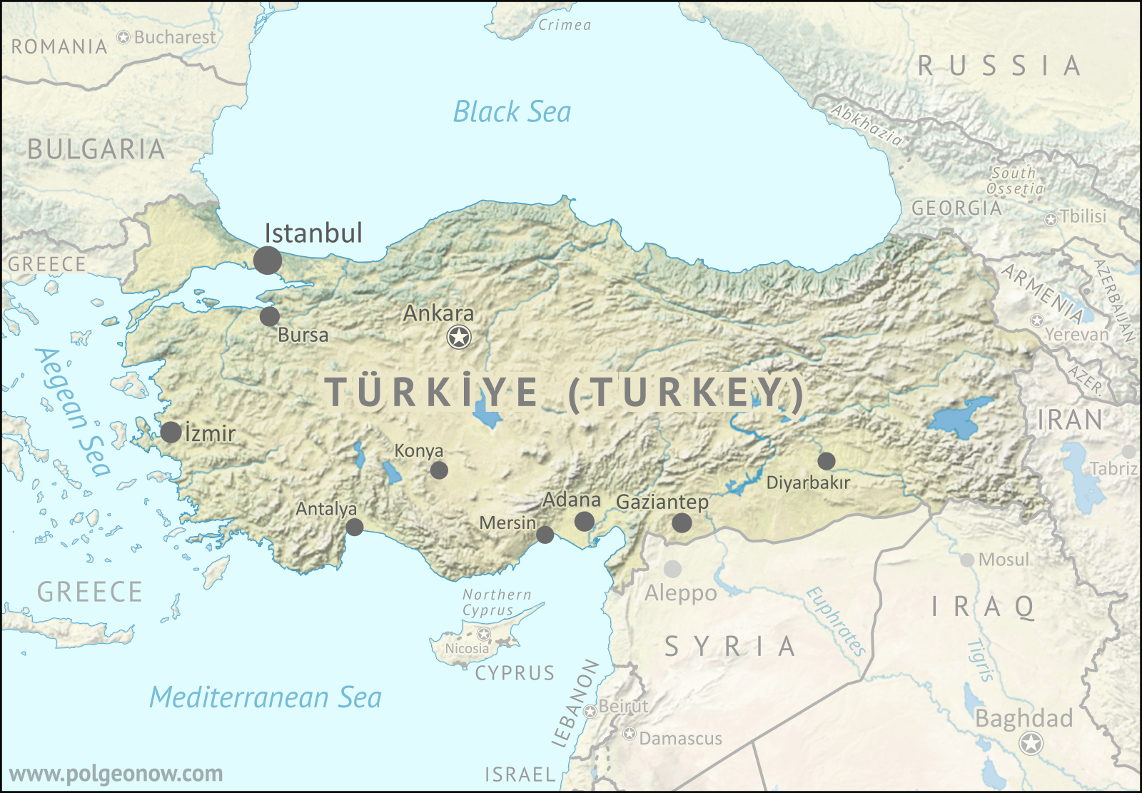
Map of Türkiye, formerly known as Turkey, which officially changed its name in English and other languages in 2022 to match the Turkish-language version. Map is in green, brown, and blue natural style with terrain, showing that more or less the entire country is mountainous, with colors varying from dark green to beige, and most areas in some hue of yellow-green. Turkey is roughly shaped like a long, horizontal rectangle (if north is treated as up), with the Black Sea along its whole northern side and the Aegean Sea to its west, with a small portion of the country in the far northwest (Eastern Thrace) separated from the rectangle (Anatolia) by the rivers connecting those two seas. The southern side of the country is bounded by the Mediterranean Sea in the west and the more-arid land of the Levant and Mesopotamia in the east. East of the country are the mountainous Southern Caucasus region and the northwestern end of the Iranian Plateau. Capital city Ankara is a bit northwest of the country's geographic center, and the larger Istanbul much farther to the northwest, straddling the gap between Eastern Thrace and Anatolia. Other cities of over a million people each, including İzmir, Adana, Bursa, Gaziantep, and several more, are located along the country's western and southern margins. Surrounding countries include Greece and Bulgaria to the west; Cyprus (and disputed Northern Cyprus), Syria, and Iraq to the southeast; and Iran, Armenia, Georgia and Azerbaijan to the east. Russia looms large just across the Black Sea to the northeast, Romania is across the sea to the northwest (plus Ukraine and disputed Crimea directly north), and Israel and Lebanon are not far off along the southward turn the Mediterranean coast, while the Aegean Sea to the west is dominated islands that are part of Greece.
Hidden image for crawlers

Turkey's "New" Name

Over the last two years, PolGeoNow readers might have noticed us using the name "Türkiye" for the country more widely known in English as "Turkey". That's because the Turkish government officially changed the country's name in English (and two other languages) about two years ago, and our policy is to call countries by what their governments say they're called, except in certain special cases. 

Türkiye, a large and influential country traditionally considered to be partly in Europe and partly in Asia, comes up a lot in news about both European and Middle Eastern geopolitics. So that means a lot of people and organizations now have to make a choice: Keep using the name they're used to, or switch the official one chosen by the country's government.

Saturday, August 22, 2020

Iraq Control Map & Timeline: Turkey Expands Control in North - August 2020 (Subscription)

SUBSCRIBERS CLICK HERE TO PROCEED TO ARTICLE AND MAP

(To see other maps in this series, view all Iraq articles.)

Research by Djordje Djukic. Map by onestopmap.com, Evan Centanni, and Djordje Djukic

Subscribe for full access to all conflict map reports!

Iraq Control Map 2020, updated to August 21. Shows areas of Iraq under Turkey's military contro, ISIS control (Islamic State/ISIL/Daesh), and under the control of the Baghdad government, the Kurdistan Peshmerga, and the Yezidi Sinjar Alliance (YBS and YJE). Marks Khamtir and Halukah Mountains (Jabal Khamtir and Jabal Halukah), controlled by Turkish forces. Colorblind accessible.
While Iraq's lines of control have mostly stayed the same since the beginning of the year, Turkey's military has been gradually increasing its control of the north. The incursion is part of the Turkish war against the Kurdish PKK, a rebel group from Turkey that now bases itself across the border in Iraq.

See all this and more on the latest update to PolGeoNow's concise, professional map of control in Iraq, including a timeline of changes since our previous Iraq map report of January 2020.

This map and report are premium content, available to paid subscribers of the PolGeoNow Conflict Mapping Service.

Want to see before you subscribe? Check out our most recent FREE SAMPLE Iraq map report!

Exclusive report includes:
  • Up-to-date map of current territorial control in Iraq, color-coded for the Iraqi government, "Islamic State" (ISIS/ISIL) fighters, Kurdistan's Peshmerga forces, and Yezidi militias. Colorblind accessible.
  • NEW: Turkish military control along the northern border, including key sites Mt. Khamtir (Jabal Khamtir) and Mt. Halukah (Jabal Halukah).
  • Detailed indication of town-by-town control, including all major cities and many smaller ones, as well as terrain, major roads, and provincial boundaries
  • Timeline of changes to the situation and related events since January, compiled by our Iraq-Syria specialist, with links to sources.
SUBSCRIBERS CLICK HERE TO PROCEED TO ARTICLE AND MAP

Not signed up yet? Click here to learn more about our professional subscription service!

Can I purchase just this map?
This map and report are not available for automated purchase to non-subscribers. If you need access or republication rights for only this map report, contact service@polgeonow.com for options.

Thursday, February 15, 2018

Syrian Civil War Map & Timeline - February 2018

There are newer versions of this map available. To see them, view all Syria updates.

Who controls what in Syria? Rebel and ISIS control map of the Syrian Civil War. Shows territorial control as of February 2018 (Free Syrian Army rebels, Kurdish YPG, Syrian Democratic Forces (SDF), Jabhat Fateh al-Sham / Hayat Tahrir al-Sham (Al-Nusra Front), Islamic State (ISIS/ISIL), and others). Includes Russia-Turkey-Iran agreed de-escalation zones and US deconfliction zone, plus recent locations of conflict and territorial control changes, such as Abu al-Duhur, Bulbul, Saraqeb, and more. Colorblind accessible.
Base map by Koen Adams of onestopmap.com, with territorial control by Evan Centanni and Djordje Djukic.
Contact us for permission to use this map.
(Subscribers click here to view this article on the member site)

Timeline by Djordje Djukic

Situation Summary

The past few weeks since our previous Syria map update have been dominated by news from two main arenas of battle, both in the country's northwest. In the most politically significant development, the Turkish military has entered the Kurdish-administrated Afrin region (also spelled "Efrin") as part of a mission, alongside allied rebel fighters, to drive Kurdish militias out of the western border region. Meanwhile, forces loyal to Syria's Assad government have made major advances in areas south of Aleppo, eliminating an enclave of the so-called "Islamic State" (IS; formerly ISIS/ISIL) and cutting into rebel control around the edges of Idlib province.

Wednesday, April 26, 2017

Syria Control Map & Timeline - April 2017 (Subscription)

SUBSCRIBERS CLICK HERE TO PROCEED TO ARTICLE AND MAP

There are newer versions of this map available. To see them, view all Syria updates.

Research by Djordje Djukic. Map by onestopmap.com, Evan Centanni, and Djordje Djukic

Subscribe for full access to all conflict map reports!

Map of fighting and territorial control in Syria's Civil War (Free Syrian Army rebels, Kurdish YPG, Syrian Democratic Forces (SDF), Jabhat Fateh al-Sham / Hayat Tahrir al-Sham (Al-Nusra Front), Islamic State (ISIS/ISIL), and others), updated to April 26, 2017. Now includes terrain and major roads (highways). Includes recent locations of conflict and territorial control changes, such as Thawra, Halfaya, Suran, Qaboun, and more. Colorblind accessible. The so-called "Islamic State" (ISIS/ISIL) has continued to lose ground in Syria to the Kurdish-led, US-backed Syrian Democratic Forces (SDF) in the north, and to rebel groups in the southern desert. Meanwhile, the Assad government has made some gains against rebels in Hama province, the Damascus area, and elsewhere.
 
See all this and more on the latest update to PolGeoNow's concise, professional Syrian Civil War control map, which includes a timeline of changes since our previous Syria map report in March, with sources cited.

This map and report are premium professional content, available to paid subscribers of the PolGeoNow Conflict Mapping Service.

Want to see before you subscribe? Check out our most recent FREE SAMPLE Syria map!

Exclusive report includes:
  • Up-to-date map of current territorial control in Syria, color-coded for the Assad government, rebel groups, "Islamic State" (ISIS/ISIL) fighters, and Kurdish/SDF forces. Colorblind accessible.
  • Special symbols indicating towns dominated by rebels of the former Nusra Front (now Hayat Tahrir al-Sham) and US-backed Syrian Democratic Forces (SDF).
  • Detailed indication of city-by-city control, including key towns and other locations important to current events.
  • Locations of recent fighting and other important events, including Thawra, Halfaya, Suran, Qaboun, and more.
  • Detailed timeline of important events and changes to territorial control since March 29, 2017, compiled by our Syria-Iraq expert, with links to sources.

SUBSCRIBERS CLICK HERE TO PROCEED TO ARTICLE AND MAP

Not signed up yet? Click here to learn more about our professional subscription service!

Can I purchase just this map?
This map and report are not available for automated purchase to non-subscribers. If you need access or republication rights for only this map report, contact service@polgeonow.com for options.

Monday, March 20, 2017

Interactive Maps: Which Places Switched Time Zones in 2016?

This article is a spin-off from our popular yearly review of political geography events. For more on changes to countries and borders in 2016, check out our main 2016 year in review article

A time zone map of the world, showing all the world's standard time zones as of the beginning of 2017, with UTC offsets.
Free map of world time zones from Wikimedia Commons, up-to-date for the beginning of 2017. See the close-ups below for interactive, before-and-after illustrations of time zone changes during 2016.

Article and additional graphics work by Evan Centanni
 

Who Controls Time Zones?

The system of dividing the world into time zones is accepted all around the world, in principle. It's an organized way of letting clocks in each part of the world hit noon around the middle of daylight hours, even if it's midnight on the other side of the world. But surprisingly, there's actually no international organization that determines time zones. Except for in the open ocean, where time zones are standardized by a loose agreement between fleets and ship operators, the dividing lines are set independently by each country's government, or even by local governments below the national level.

Friday, November 4, 2016

Iraq Control Map & Timeline: The Siege of Mosul - November 2016 (Subscription)

SUBSCRIBERS CLICK HERE TO PROCEED TO ARTICLE AND MAP

There are newer versions of this map available. To see them, view all Iraq updates.

Research by Djordje Djukic. Map by onestopmap.com, Evan Centanni, and Djordje Djukic

Subscribe for full access to all conflict map reports!

Detailed map of territorial control in Iraq as of November 4, 2016, including territory held by the so-called Islamic State (ISIS, ISIL), the Baghdad government, and the Kurdistan Peshmerga. Shows developments in the ongoing coalition battle to recapture the city of Mosul. Includes key locations from recent events, such as Bashiqa, Sharqat, and Bartella. Colorblind accessible. The battle is now on for Mosul, the so-called Islamic State's (ISIS/ISIL) biggest city. A grand coalition of Iraqi military, Shiite and Sunni militias, and Kurdistan's Peshmerga forces - with controversial help from the Turkish military - have now entered and mostly surrounded the city.
 
See all this and more on the latest update to PolGeoNow's concise, professional map of control in Iraq's civil war, including a timeline of changes since our previous Iraq map report of September 2016.

This map and report are premium professional content, available to paid subscribers of the PolGeoNow Conflict Mapping Service.

Want to see before you subscribe? Check out our most recent FREE SAMPLE Iraq map report!

Exclusive report includes:
  • Up-to-date map of current territorial control in Iraq, color-coded for the Iraqi government, "Islamic State" (ISIS/ISIL) extremists, and Kurdistan's Peshmerga forces. Colorblind accessible.
  • Detailed indication of town-by-town control, including provincial boundaries, all major cities, and many smaller ones
  • Markers for key areas of recent fighting such as Mosul, Bashiqa, Sharqat, and Bartella
  • Timeline of changes to the situation since early September, compiled by our Iraq specialist, with links to sources
SUBSCRIBERS CLICK HERE TO PROCEED TO ARTICLE AND MAP

Not signed up yet? Click here to learn more about our professional subscription service!

Can I purchase just this map?
This map and report are not available for automated purchase to non-subscribers. If you need access or republication rights for only this map report, contact service@polgeonow.com for options.

Monday, October 3, 2016

Syrian Civil War Control Map & Report: October 2, 2016 (Subscription)

SUBSCRIBERS CLICK HERE TO PROCEED TO ARTICLE AND MAP

There are newer versions of this map available. To see them, view all Syria updates.

Research by Djordje Djukic. Map by onestopmap.com, Evan Centanni, and Djordje Djukic

Subscribe for full access to all conflict map reports!

Map of fighting and territorial control in Syria's Civil War (Free Syrian Army rebels, Kurdish YPG, Syrian Democratic Forces (SDF), Jabhat Fateh al-Sham (Al-Nusra Front), Islamic State (ISIS/ISIL), and others), updated for October 2016. Now includes terrain and major roads (highways). Includes recent locations of conflict and territorial control changes, such as Dabiq, Halfaya, Suran, Jarabulus, and more (colorblind accessible). During the past month, a continued Turkish military incursion into Syria completely cut off the so-called "Islamic State" from the self-proclaimed caliphate's last international border in the region (other than its boundaries with Syrian and Iraqi territory).

Meanwhile, the Assad government and rebel groups have continued to take territory from each other despite a brief attempt at a country-wide ceasefire.
 
See all this and more on the latest update to PolGeoNow's concise, professional Syrian Civil War control map, which includes a timeline of changes since our previous Syria map report in late August, with sources cited.

This map and report are premium professional content, available to paid subscribers of the PolGeoNow Conflict Mapping Service.

Want to see before you subscribe? Check out our most recent FREE SAMPLE Syria map!

Exclusive report includes:
  • Up-to-date map of current territorial control in Syria, color-coded for the Assad government, rebel groups, "Islamic State" (ISIS/ISIL) fighters, and Kurdish/SDF forces. Colorblind accessible.
  • Special symbols indicating towns dominated by rebels of the former Nusra Front (now Jabhat Fateh al-Sham) and US-backed Syrian Democratic Forces (SDF).
  • Detailed indication of city-by-city control, including key towns and other locations important to current events.
  • Locations of recent fighting and military operations, including Dabiq, Halfaya, Suran, Jarabulus, and more.
  • Detailed timeline of important events and changes to territorial control since August 27, 2016, compiled by our Syria-Iraq expert, with links to sources.

SUBSCRIBERS CLICK HERE TO PROCEED TO ARTICLE AND MAP

Not signed up yet? Click here to learn more about our professional subscription service!

Can I purchase just this map?
This map and report are not available for automated purchase to non-subscribers. If you need access or republication rights for only this map report, contact service@polgeonow.com for options.

Monday, August 29, 2016

Syrian Civil War Control Map & Report: August 2016 (Subscription)

SUBSCRIBERS CLICK HERE TO PROCEED TO ARTICLE AND MAP

There are newer versions of this map available. To see them, view all Syria updates.

Research by Djordje Djukic. Map by onestopmap.com, Evan Centanni, and Djordje Djukic

Subscribe for full access to all conflict map reports!

Map of fighting and territorial control in Syria's Civil War (Free Syrian Army rebels, Kurdish YPG, Syrian Democratic Forces (SDF), Al-Nusra Front, Islamic State (ISIS/ISIL), and others), updated for August 2016. Now includes terrain and major roads (highways). Includes recent locations of conflict and territorial control changes, such as Jarabulus, Manbij, Daraya, Hasakah, and more (color blind accessible). Syria's war has seen several major territorial changes in the past month, with a Turkish military intervention bringing IS defeats even as the rival, Kurdish-led Syrian Democratic Forces have captured key territory from both IS and the Assad government. Meanwhile, the government has scored some major victories of its own against rebel forces.
 
See all this and more on the latest update to PolGeoNow's concise, professional Syrian Civil War control map, which includes a timeline of changes since our previous Syria map report in late July, with sources cited.

This map and report are premium professional content, available to paid subscribers of the PolGeoNow Conflict Mapping Service.

Want to see before you subscribe? Check out our most recent FREE SAMPLE Syria map!

Exclusive report includes:
  • Up-to-date map of current territorial control in Syria, color-coded for the Assad government, rebel groups, "Islamic State" (ISIS/ISIL) fighters, and Kurdish/SDF forces. Color blind accessible.
  • Special symbols indicating towns dominated by rebels of the Nusra Front (now Jabhat Fateh al-Sham) and US-backed Syrian Democratic Forces (SDF).
  • Detailed indication of city-by-city control, including key towns and other locations important to current events.
  • Locations of recent fighting and military operations, including Jarabulus, Manbij, Daraya, Hasakah, and more.
  • Detailed timeline of important events and changes to territorial control since July 25, 2016, compiled by our Syria-Iraq expert, with links to sources.

SUBSCRIBERS CLICK HERE TO PROCEED TO ARTICLE AND MAP

Not signed up yet? Click here to learn more about our professional subscription service!

Can I purchase just this map?
This map and report are not available for automated purchase to non-subscribers. If you need access or republication rights for only this map report, contact service@polgeonow.com for options.

Saturday, April 11, 2015

Syria Civil War Control Map: April 2015 (Subscription)

There are newer versions of this map available. To see them, view all Syria updates.

Map of fighting and territorial control in Syria's Civil War (Free Syrian Army rebels, Kurdish groups, Al-Nusra Front, Islamic State (ISIS/ISIL) and others), updated for April 2015. Highlights recent locations of conflict and territorial control changes, such as Yarmouk, Idlib, Nassib border crossing, Busra, and Tel Hamis.

Download PDF:
Buy now


(Subscribe via Paypal to view all premium content online)
Research by T.H., with additional reporting by Evan Centanni

Since January, the Islamic State has captured part of Syria's capital city, while rebels have gained important ground in both the north and the south. Meanwhile, Kurdish militias have scored victories against the Islamic State on the northeastern front. 

See all this and more on the newest update to PolGeoNow's popular Syria control map, and read a timeline of changes since our previous Syria map report at the end of January.

This map and report are exclusive premium content, available to paid subscribers or for separate purchase.
Download PDF (US$19.99)

Exclusive map report includes:
  • Up-to-date map of current territorial control in Syria, color-coded for the Assad government, rebel groups, Islamic State (ISIS/ISIL) extremists, and Kurdish self-protection forces
  • Detailed indication of city-by-city control, highlighting key towns and other locations relevant to current events
  • Locations of recent fighting and military operations, including Yarmouk, Idlib, Nassib border crossing, Busra, and the Tomb of Suleyman Shah (site of Turkey's brief military incursion in February).
  • Timeline of changes to important events since the end of January, plus summary of important territorial changes in recent months.

MEMBERS CLICK HERE TO PROCEED TO ARTICLE AND MAP

NOT A MEMBER YET? SUBSCRIBE NOW!