Thursday, February 3, 2022

Parade of Nations: Which Countries Are (and Aren't) in the Olympics? (Beijing 2022)

This is an older version of our Parade of Nations article. Click here to see the newest edition!  

This is an updated version of an article first published in 2012. To see previous versions, view all Olympics articles on PolGeoNow.


World map showing the five continental associations of National Olympic Committees, including all nations eligible for the Beijing 2022 Olympic Games.
Map of all countries in the Olympics and their regional associations. By Evan Centanni, modeled after this map.


After the delay to the Tokyo 2020 Summer Games, the Olympics are back on schedule! The 2022 Winter Olympics in Beijing, China officially open tomorrow, February 4th. They'll be the second Olympics hosted by China, after the 2008 Summer Games, and will even use some of the same facilities. 

These are the third Olympics in a row to be held in East Asia, after PyeongChang 2018 and Tokyo 2020 (actually held in 2021) and only the fourth-ever Winter Olympics to be held outside of Europe and North America, following the 1972 and 1998 games hosted in Japan and the 2018 PyeongChang games in South Korea.

Of course, it wouldn't be an Olympic opening ceremony without the Parade of Nations. But how many countries are there in the games, and is everyone included? Read on for PolGeoNow's updated guide to the roster of Olympic Nations...

Friday, January 28, 2022

Yemen Control Map & Report: Houthis on the Backstep - January 2022 (Subscription)

SUBSCRIBERS CLICK HERE TO PROCEED TO ARTICLE AND MAP

There are newer versions of this map available. To see them, view all Yemen articles on PolGeoNow.

Timeline by Djordje Djukic. Map by Evan Centanni, Djordje Djukic, and onestopmap.com

Map of what's happening in Yemen as of January 2022, including territorial control for the unrecognized Houthi government, president-in-exile Hadi and his allies in the Saudi-led coalition, and the UAE-backed southern separatist Southern Transitional Council (STC), plus major areas of operations of Al Qaeda in the Arabian Peninsula (AQAP). Includes recent locations of fighting and other events, including Balaq al-Sharqi, Usaylan, Harib, Yatmah, Batr, and many more.
Subscribe for full access to all conflict map reports!

Yemen's internationally-recognized Hadi government has won a bit of breathing room in recent weeks, rolling back a swath of Houthi territory south of Marib, though Houthi forces still retain a foothold at the city's doorstep.

See all this and more on the newest update to PolGeoNow's Yemen territorial control map, which includes a timeline of changes and important events since our previous Yemen map report in November.

This map and report are premium content available to paid subscribers of the PolGeoNow Conflict Mapping Service.

Want to see before you buy? Check out our most recent FREE SAMPLE Yemen map report!

Exclusive report includes:
  • Up-to-date map of current territorial control in Yemen, color-coded for the pro-Hadi coalition, the separatist Southern Transitional Council (STC), Houthi forces, and major presence of Al Qaeda in the Arabian Peninsula (AQAP)
  • Detailed indication of town-by-town control, including provincial boundaries, all major cities, and many smaller ones
  • Markers for recent areas of fighting, including Balaq al-Sharqi, Usaylan, Harib, Batr, and many more
  • Timeline of changes to the situation since November 30, 2021, with links to sources 

SUBSCRIBERS CLICK HERE TO PROCEED TO ARTICLE AND MAP

Not a member yet? Click here to learn more about our professional subscription service!

Can I purchase just this map?
This map and report are not available for automated purchase to non-subscribers. If you need access or republication rights for only this map report, contact service@polgeonow.com for options.

Tuesday, January 25, 2022

Ethiopia War Map: Tigray Rebel Advance on Capital & Control Today (Nov. 2021/Jan. 2022)

(There are newer versions of this map available. To see them, view all Ethiopia articles on PolGeoNow.)

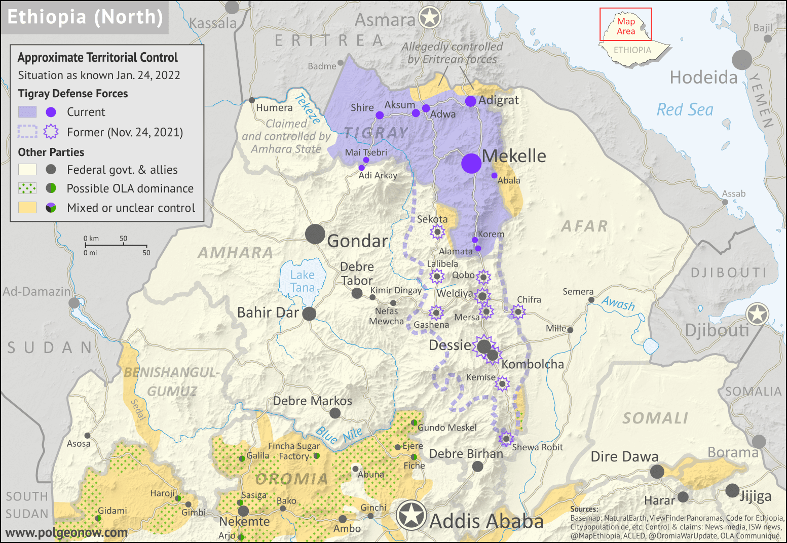
As a followup to the three Tigray war maps we've published as guest features from Daniel of Passport Party, PolGeoNow is pleased to present our new in-house map of control in Ethiopia's ongoing civil war. The new map shows Tigray rebel control both today and at its greatest extent last November, while also highlighting a second insurgency by allied rebel group the Oromo Liberation Army.

Ethiopia war map for late 2021 and early 2022, showing Tigray rebel control both at its height in November 2021, extending far down into Amhara state and near national capital Addis Ababa, and at present day (January 24, 2022). Also indicates areas claimed to be controlled by the Oromo Liberation Army in western and central Ethiopia. Colorblind accessible.
Map by Evan Centanni and Djordje Djukic. Terrain data sourced from ViewFinderPanoramas.
Contact us for permission to use this map.

(Subscribers click here to view this article in the member area)

Timeline by Djordje Djukic, with additional reporting by Evan Centanni

Rebel Advance on Addis Ababa - and Subsequent Retreat

In the five months since our previous report on Ethiopia's civil war, Tigray rebels expanded their control far south of their home state's borders, nearly reaching the national capital city of Addis Ababa. However, despite assistance from another Ethiopian rebel group, their gains were eventually reversed, with Ethiopian federal government forces and allies pushing them back within the boundaries of Tigray state. Now, the situation has almost returned to the same place it was when the war began, with Tigray largely controlled by rebels associated with its former state government, while neighboring Amhara state controls its own territory plus a section of western Tigray.

Friday, December 17, 2021

Referendum 3 of 3: New Caledonia Won't Become Independent

Parts of this article are adapted from our 2020 New Caledonia referendum explainer, but have been revised and updated for the latest vote.

The islands of New Caledonia, and their location in the South Pacific. Map by NormanEinstein (CC BY-SA; source)
The South Pacific islands of New Caledonia voted again last weekend on whether to become independent from France, in the last of a series of three referendums. As in 2018, and again last year, the anti-independence side has won the majority of the votes.

But this time was much different. In 2018, 43% of voters chose the independence option, and in 2020 that proportion grew to 47%. But last weekend, amid calls for a boycott from pro-independence campaigners, a only a staggeringly-small 3.5% of participants voted to separate from France. Total voter turnout was barely half the amount from last year.

Why did this happen, and what now? Read on for the answers.

Tuesday, December 14, 2021

Somalia Control Map & Timeline - December 2021

There are newer versions of this map available. To see them, view all Somalia articles on PolGeoNow.

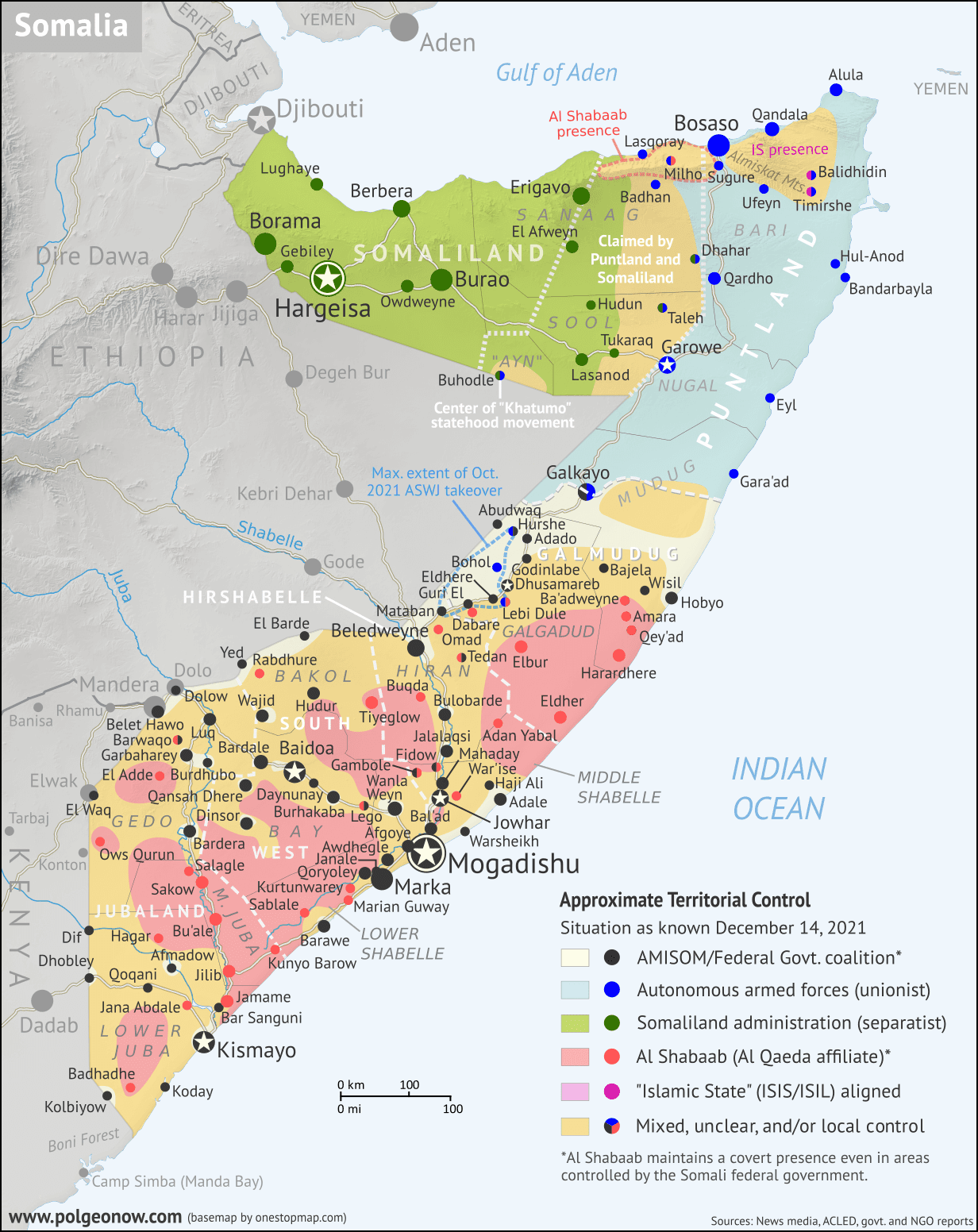
Who controls Somalia? Map (December 2021). With states, regions, and territorial control. Best Somalia control map online, thoroughly researched, detailed but concise. Shows territorial control by Federal Government of Somalia (FGS), Al Shabaab, so-called Islamic State (ISIS/ISIL), separatist Somaliland, autonomous state Puntland, and boundaries of additional federal member states Galmudug, Jubaland, South West, and Hirshabelle. Now labels state capitals and disputed boundaries between Somaliland and Puntland, as well as key towns from recent news such as Ba'adweyne, Amara, Qey'ad, Marian Guway, Balidhidhin, and more. Updated to December 14, 2021. Colorblind accessible.
Base map by Koen Adams of onestopmap.com, with territorial control by Evan Centanni and Djordje Djukic.
Contact us for permission to use this map.

(Subscribers click here to view this article in the member area)

Timeline by Evan Centanni and Djordje Djukic

Somalia Crisis Timeline: Political and Military Disarray in 2021

In the nearly 10 months since PolGeoNow's previous Somalia control map report, the country's news cycle has been dominated by a series of interconnected political crises that have led the federal government's military to the brink of civil war. All the while, the fight against Al Qaeda affiliate Al Shabaab, which operates a parallel government across much of Somalia's countryside, has continued to see a mix of victories and defeats for each side. And while the standoff between the federal army and Jubaland state forces has ended, new regional conflicts have erupted in Hirshabelle and Galmudug states, including a major resurgence of the controversial ASWJ militia.

Read on for concise summaries of the past 10 months' political crises and military trends, followed by a detailed timeline of events since February. Sources for our reporting, and for changes to the map since last time, are covered in the detailed timeline and the additional source notes at the bottom of the page.