Monday, June 5, 2023

Jan. 2023: Croatia Switches to Euro Currency, Joining Eurozone (Map)

This article covers the latest changes to PolGeoNow's map of which countries use the euro.

Map of the Eurozone (euro area), showing which countries use the euro as their currency. Includes members, pre-members (ERM II or ERM-2 waiting area), EU non-members using the euro, and other EU countries. Color blind accessible. Updated to June 2023 with the recent entry of Croatia into the Eurozone.
Map by Evan Centanni, from blank map by Ssolbergj. License: CC BY-SA

Croatia Joins Eurozone, Leaves ERM II

On January 1, 2023, Croatia retired the Croatian kuna currency as the country's official money, replacing it with the shared European currency known as the "euro". By doing this, the country became the 20th official member of the "euro area", better known as the Eurozone - not to be confused with the European Union (EU), a closely-related organization that the Eurozone basically part of. On the same day, Croatia also joined Europe's free-travel Schengen Area, another EU-connected grouping of countries.

Which Countries Use the Euro in 2023? (Map of the Eurozone)

This map and explainer article, originally from 2016, have been updated to June 2023 to cover the recent addition of Croatia to the Eurozone. You can see previous versions of the map by viewing all Eurozone articles on PolGeoNow.

Map of the Eurozone (euro area), showing which countries use the euro as their currency. Includes members, pre-members (ERM II or ERM-2 waiting area), EU non-members using the euro, and other EU countries. Color blind accessible. Updated to June 2023 with the recent entry of Croatia into the Eurozone.
Map by Evan Centanni, from blank map by Ssolbergj. License: CC BY-SA

Article by Caleb Centanni and Staff Writer 

What is the Eurozone?

Officially called the "euro area", the Eurozone is a nickname for the group of countries in Europe that share a single currency, called the euro, as their official money. The euro currency is managed by the European Union (EU), but many countries in the EU don't use the euro, and some countries outside the EU do use it. The European Central Bank, headquartered in Frankfurt, Germany, is in charge of regulating the currency and making euro coins and bills (bank notes).

Saturday, June 3, 2023

Ukraine: Map of Russian Control After Capture of Bakhmut - May 2023 (Subscription)

SUBSCRIBERS CLICK HERE TO VIEW FULL ARTICLE AND MAP:
Old Portal (members.polgeonow.com) | New Portal (controlmaps.polgeonow.com)


There are newer versions of this map available. To see them, view all Ukraine articles on PolGeoNow.
 

Research by Djordje Djukic. Map by Evan Centanni and Djordje Djukic

Subscribe for full access to all conflict map reports!

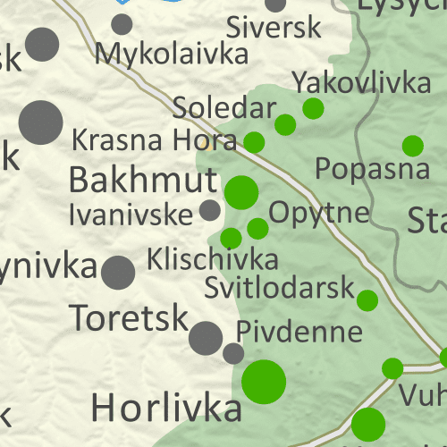
Thumbnail previewing map of Russian-controlled territory in Ukraine on May 27, 2023. In addition to the Crimean peninsula, which Russia had already seized in 2014, and parts of the far eastern Donetsk and Luhansk provinces (the Donbas region) already controlled by Russia-backed separatist rebels (and formerly declared independent as the Donetsk and Lugansk People's Republics), Russian forces still control a wide belt of territory just north of Crimea, including large parts of Kherson and Zaporizhzhia provinces, as well as large additional areas of Donetsk and Luhansk provinces. Meanwhile, all of those provinces are now claimed by the Russian government as parts of Russia, creating a new claimed international border through what was until recently undisputed eastern Ukraine. Map includes key locations from the news, such as Bakhmut (the small city recently captured by Russia), Synkivka, Uman, Pavlohrad, and more. Colorblind accessible.

Russia and its allies have completed their control of Bakhmut in Donetsk province after ten months of bloody battles for the small city. Fighting continues at many other places along the frontlines, including advances for both sides, though more of them in favor of Russia than Ukraine.

See all this and more on the latest update to PolGeoNow's concise, professional Ukraine war control map, which includes a detailed chronicle of changes and events since our previous Ukraine map report of March 26, with sources cited, as well as a close-up map of control within the claimed borders of the Donetsk and Lugansk People's Republics (now claimed to be self-governing regions within Russia).

This map and report are premium content, available to paid subscribers of the PolGeoNow Conflict Mapping Service.

Want to see before you subscribe? Check out our most recent FREE SAMPLE Ukraine map!

Exclusive map report includes:

  • Up-to-date illustration of current territorial control in Ukraine, color-coded for the Ukrainian government on one side and the Russian military and allied forces on the other side, with areas of uncertainty indicated. Colorblind accessible.
  • Darker color indicating which areas were already under Russian or allied control before the 2022 invasion began
  • Lines showing Russia's newly-claimed border after its annexations of Donetsk, Luhansk, Zaporizhzhia, and Kherson provinces.
  • Preview thumbnail of map of territorial control within the claimed borders of the self-declared Donetsk People's Republic (DPR) and Lugansk People's Republic (LPR), which now consider themselves part of Russia, updated to May 27, 2023, after Russia completed its capture of Bakhmut. Map shows that the vast majority of the LPR, otherwise known as Ukraine's Luhansk province, is now under the control of Russia, while Russian forces also control over half of the DPR, or Ukraine's Donetsk province, including the major central and southern cities of Donetsk, Horlivka, Makiyivka, and Mariupol. Includes key locations from the news, such as Novoselivske, Bilohorivka, Soledar, Pervomaiske, and many more. Colorblind accessible.
    Donbas close-up map
    Close-up map of territorial control within the self-proclaimed boundaries of the Donetsk People's Republic and Lugansk People's Republic, which now claim to be part of Russia
  • Detailed indication of city-by-city control, including key towns and other locations important to current events
  • Locations of recent control changes and other important events, including Bakhmut, Synkivka, Uman, Pavlohrad, and more
  • Detailed timeline of important events and changes to territorial control since April 21, 2023, with links to sources.

SUBSCRIBERS CLICK HERE TO VIEW FULL ARTICLE AND MAP:
Old Portal (members.polgeonow.com) | New Portal (controlmaps.polgeonow.com)


Not signed up yet? Click here to learn more about our professional subscription service!

Can I purchase just this map?
This map and report are not available for automated purchase to non-subscribers. If you need access or republication rights for only this map report, contact service@polgeonow.com for options.

Monday, April 24, 2023

Ukraine: Map of Russian Control in April 2023 (Subscription)

SUBSCRIBERS CLICK HERE TO VIEW FULL ARTICLE AND MAP:
Old Portal (members.polgeonow.com) | New Portal (controlmaps.polgeonow.com)


There are newer editions of this map available. To see them, view all Ukraine articles on PolGeoNow.


Research by Djordje Djukic. Map by Evan Centanni and Djordje Djukic

Subscribe for full access to all conflict map reports!

Thumbnail previewing map of Russian-controlled territory in Ukraine on April 21, 2023. In addition to the Crimean peninsula, which Russia had already seized in 2014, and parts of the far eastern Donetsk and Luhansk provinces (the Donbas region) already controlled by Russia-backed separatist rebels (and formerly declared independent as the Donetsk and Lugansk People's Republics), Russian forces still control a wide belt of territory just north of Crimea, including large parts of Kherson and Zaporizhzhia provinces, as well as large additional areas of Donetsk and Luhansk provinces. Meanwhile, all of those provinces are now claimed by the Russian government as parts of Russia, creating a new claimed international border through what was until recently undisputed eastern Ukraine. Map includes key locations from the news, such as Bakhmut, Marinka, Synkivka, Orikhiv, and more. Colorblind accessible.

In recent weeks Russia has continued to slowly advance within the town of Bakhmut, with both sides making small gains in other parts of Donetsk and Luhansk. We've also made some small corrections to the map in Kharkiv and Zaporizhzhia provinces based on new information.

See all this and more on the latest update to PolGeoNow's concise, professional Ukraine war control map, which includes a detailed chronicle of changes and events since our previous Ukraine map report of March 26, with sources cited, as well as a close-up map of control within the claimed borders of the Donetsk and Lugansk People's Republics (now claimed to be self-governing regions within Russia).

This map and report are premium content, available to paid subscribers of the PolGeoNow Conflict Mapping Service.

Want to see before you subscribe? Check out our most recent FREE SAMPLE Ukraine map!

Exclusive map report includes:

  • Up-to-date illustration of current territorial control in Ukraine, color-coded for the Ukrainian government on one side and the Russian military and allied forces on the other side, with areas of uncertainty indicated. Colorblind accessible.
  • Darker color indicating which areas were already under Russian or allied control before the 2022 invasion began
  • Lines showing Russia's newly-claimed border after its annexations of Donetsk, Luhansk, Zaporizhzhia, and Kherson provinces.
  • Preview thumbnail of map of territorial control within the claimed borders of the self-declared Donetsk People's Republic (DPR) and Lugansk People's Republic (LPR), which now consider themselves part of Russia, updated to April 21, 2023. Map shows that the vast majority of the LPR, otherwise known as Ukraine's Luhansk province, is now under the control of Russia, while Russian forces also control over half of the DPR, or Ukraine's Donetsk province, including the major central and southern cities of Donetsk, Horlivka, Makiyivka, and Mariupol. Includes key locations from the news, such as Bakhmut, Marinka, Avdiivka, Bilohorivka, and many more. Colorblind accessible.
    Donbas close-up map
    Close-up map of territorial control within the self-proclaimed boundaries of the Donetsk People's Republic and Lugansk People's Republic, which now claim to be part of Russia
  • Detailed indication of city-by-city control, including key towns and other locations important to current events
  • Locations of recent control changes and other important events, including Bakhmut, Marinka, Avdiivka, Bilohorivka, and many more
  • Detailed timeline of important events and changes to territorial control since March 26, 2023, with links to sources.

SUBSCRIBERS CLICK HERE TO VIEW FULL ARTICLE AND MAP:
Old Portal (members.polgeonow.com) | New Portal (controlmaps.polgeonow.com)


Not signed up yet? Click here to learn more about our professional subscription service!

Can I purchase just this map?
This map and report are not available for automated purchase to non-subscribers. If you need access or republication rights for only this map report, contact service@polgeonow.com for options.

Thursday, April 20, 2023

Map: Which Countries are in the European Union in 2023, Which Aren't, and Which Want to Join?

This map and article have been revised and updated to April 2023. No new countries have joined the EU since our last update in 2020, but there are three new candidate countries and one new "potential candidate".

Map of the European Union, including all member countries, official candidate countries, and potential candidate countries, as of April 2023, updated for the recognition of Ukraine, Moldova, and Bosnia as membership candidates, and Georgia as a potential candidate (colorblind accessible). Also file under: Map of European Union Member Countries.
Map by Evan Centanni, from blank map by Ssolbergj. License: CC BY-SA