Tuesday, July 23, 2024

How Many Countries Are There in the World in 2024?

This article, originally from 2011, has been revised and updated to July 2024. You can view older versions of the article in our archives. The main update from last year is the surrender of the self-proclaimed Artsakh Republic (Nagorno-Karabakh), whose territory is now controlled by Azerbaijan.

How many countries: map of the world
A world political map published by the US government.

One of the most basic questions for map-lovers is "How many countries are there in the world?" But anyone who just gives you a simple number isn't telling the whole truth. It actually depends a lot on how you define a "country". Here are six of the most common answers, each correct in its own way:

Saturday, June 29, 2024

Israel / Palestine: Map of Control Amid Rafah Offensive - June 27, 2024 (Subscription)

SUBSCRIBERS CLICK HERE TO VIEW FULL ARTICLE AND MAP:
Old Portal (members.polgeonow.com) | New Portal (controlmaps.polgeonow.com)


There are newer editions of this map available. To see them, view all Israel articles or Palestine articles on PolGeoNow.

Map by Evan Centanni, timeline by Djordje Djukic with Evan Centanni

Subscribe for full access to all conflict map reports!

Thumbnail preview of map of who controlled Palestine and Israel's claimed territories on June 27, 2024, during the so-called Rafah offensive. Shows both Israeli and Palestinian Authority administration (Fatah and Hamas factions indicated separately). Includes bigger West Bank map (Area A, Area B, and Area C). Map also includes Gaza Strip, Golan Heights, major cities and Israeli settlements, UN peacekeeper deployments (UNIFIL in Lebanon and UNDOF in Syria), no man's land, Golan Heights buffer zone (area of separation, AOS), and Shebaa Farms. New edition also shows so-called Gaza Envelope and Confrontation Line zones, the areas of Israel proper are under the greatest military restrictions. Includes all major cities and various key towns and sites from the news, like Rafah, Nuseirat Refugee Camp, the US floating pier (humanitarian aid pier), Mount Meron, Hebbariye, Jenin, Tulkarm, and more. Now with improved colorblind accessibility.

Over the last four months, Israel first withdrew most its forces from the Gaza Strip, soon sent them back into certain areas, then began a scaled-down version of its long-promised Rafah offensive. Its forces now hold part of Rafah and other specific areas, while the UN says there's “no authority in most of the territory”. 

Meanwhile, related violence has continued along the Lebanon border, in the West Bank, and in the Red Sea, with broader Middle East tensions reaching a peak in mid-April with a direct exchange of fire between Israel and Iran.

See all this and more in the latest update to PolGeoNow's widely-acclaimed map of territorial administration in the Israel/Palestine area. In addition to the updated map, the report also includes a detailed chronicle of changes and events since March 4, 2024, the date illustrated by our previous Israel/Palestine control map.

This map and report are premium content, available to paid subscribers of the PolGeoNow Conflict Mapping Service.

Want to see before you subscribe? Check out our most recent FREE SAMPLE Israel/Palestine map report!

Exclusive map report includes:

  • Up-to-date illustration of current territorial control across all areas claimed by either Israel or Palestine, including Hamas and Israeli military control in the Gaza Strip (not in extreme detail), as well as UN peacekeeper deployments just outside the region
  • Closer-up inset map showing the divisions in the West Bank: Israeli military control ("Area C", including Israeli settlements), Fatah-led Palestinian jurisdiction ("Area A"), zones of shared administration ("Area B"), and the (annexed) area of Israeli civilian control in East Jerusalem
  • Lines illustrating the pre-1967 ceasefire boundaries separating Israel proper from the Palestinian-claimed Gaza Strip and West Bank, as well as the Syria-claimed Golan Heights
  • Labels for contentious areas, like the Gaza Strip, West Bank, Golan Heights, Shebaa Farms, and "no man's land"
  • Illustration of which parts of Israel proper are subject to the greatest restrictions by military decree under current war powers: the "Gaza Envelope" in the south and the "Confrontation Line" in the north, as well as known closed areas of the Golan Heights
  • Detailed indication of city-by-city control, including key towns and other locations important to current events, including in the West Bank and along the border with Israel and Lebanon
  • Locations of recent control changes and other important events, including Rafah, Nuseirat Refugee Camp, the US floating humanitarian pier, Mt. Meron, Hebbariye, Jenin, Tulkarm, and more
  • Detailed timeline of important events and changes to territorial control since March 4, 2024, with links to sources.
  • Additional timeline entries chronicling events in all four additional fronts to the conflict: (1) the Lebanon border, where Israel and Hezbollah are engaged in cross-border strikes; (2) the West Bank, where near-daily Israeli raids on Palestinian-governed cities have led to intense clashes; (3) attacks on Western shipping in the Red Sea and Gulf of Aden near Yemen, where the US and UK have retaliated militarily against the Yemeni "Houthi" government; and (4) the recent flare-up of direct violence between Israeli and Iran, including Israeli strikes on Iran-aligned targets in Syria (Fronts 3 and 4 are not illustrated on the map).

SUBSCRIBERS CLICK HERE TO VIEW FULL ARTICLE AND MAP:
Old Portal (members.polgeonow.com) | New Portal (controlmaps.polgeonow.com)


Not signed up yet? Click here to learn more about our professional subscription service!

Can I purchase just this map?
This map and report are not available for automated purchase to non-subscribers. If you need access or republication rights for only this map report, contact service@polgeonow.com for options.

Tuesday, June 11, 2024

Sudan Control Map & Timeline: Former Rebels Join Fight - June 2023

Hidden image for crawlers(To see other maps in this series, view all Sudan articles on PolGeoNow.)

This marks the first fully up-to-date edition of our new Sudan map series, after several retrospective reports on the situations in previous months. The latest of those, featuring a map of control at the end of January 2024, is being published alongside this one. 

To access our full catalog of map reports covering control in Sudan and many other countries, sign up for our Control Map Subscription Service - popular with major government and international organizations, but available to individual subscribers at just US$19.99 per month!

Sudan War: Map of who controlled what in Sudan on June 11, 2024, showing the situation after most of Darfur's former rebel Joint Force joined the fight alongside the army. Best Sudan control map online, thoroughly researched for maximum accuracy. Shows territorial control by the government-affiliated Sudanese Armed Forces (SAF), the Rapid Support Forces (RSF) paramilitary, and rebel groups in Sudan including the Sudan Liberation Army/Movement's Abdelwahid El Nur faction (SLA-AW/SLM-AW) in Darfur's Jebel Marra, the SPLM-N faction of Abdelaziz El Hilu in the Two Areas of South Kordofan (Nuba Mountains) and Blue Nile. Also shows the area of control of the Ngok Dinka Abyei Area Administration (AAA) within the disputed Abyei Box, and the known bases and area of operation of the remaining Neutral Joint Force of former rebels in Darfur who haven't taken sides. Includes disputed territories claimed by other countries, including the Halaib Triangle, Bir Tawil, and Wadi Halfa Salient along the border with Egypt, plus Kafia Kingi, 14-mile, Abyei, Heglig (Hejlij), Kaka, and Bebnis along the South Sudan border, showing which parts are controlled by which country. Includes key towns and other locations from the news, including the Sennar Sugar Factory, Omdurman, Bahri, El Fau (Al Fao), Jebel Dayir, Delling (Dilling, Dalang), Zurrug, Mellit, Korma, Ayn Siro, Tina border crossing, Misteriya, Al Dabbah (El Debba), Babanusa, Lagawa (Laqawa), Um Rawaba and many more.
Map by Evan Centanni and Djordje Djukic, starting from base map by Koen Adams of onestopmap.com. "Neutral Joint Force" has been redefined to exclude Darfuri former rebel groups who have joined the fight against the RSF, now subsumed under "Govt./SAF & allies". See below for a detailed accounting of which groups are included in each territorial control category. To use this map in your own materials, please contact us to arrange permission.

Timeline by Djordje Djukic and Evan Centanni

Darfur's Joint Force Enters War Against RSF, Kicking off Battle of El Fasher

In the four months since the date depicted on PolGeoNow's previous Sudan control map, lines of control have remained mostly stable, except for a major SAF breakthrough within the city of Omdurman and the RSF's takeover of Mellit, the headquarters of Darfur's Joint Force coalition. Other changes to the map have been made to show where new evidence has emerged of RSF presence (or lack thereof), but these don't represent major victories or defeats. The bigger story has, instead, been a critical realignment in alliances.

The leaders of Darfur's most prominent "Joint Force" former rebel groups, the SLM-MM and JEM-Jibril, have been outspoken against the RSF since November 2023, even recruiting and training new SAF-allied forces in eastern Sudan. But until recently, their field commanders based in Darfur, where the core of each group's forces were stationed, had kept unofficially neutral in the war, helping preserve a year-long, citizen-mediated ceasefire in the city of El Fasher. That all changed after Joint Force troops started fighting alongside the SAF around Khartoum in late March, leading to RSF retaliation across Sudan. By mid-April, the group's major commanders in Darfur had joined the fight, kicking off a devastating, full-scale battle for the region's capital.

A few months ago, "neutral Joint Force" was a useful label for most of the former rebel forces in Darfur, but today it can only fairly apply to the minority of factions who refused to enter the battle, and now say they're launching an official "Neutral Joint Force" separate from the larger SAF-allied one. Our map has been changed accordingly, now subsuming SAF-allied groups within "Govt./SAF and allies", while reserving the "Neutral Joint Force" symbols from the January map for the new strictly neutral coalition. Nearly every Darfuri former rebel group has split into factions over the question of whether to ally with the SAF, with the longtime leaders of the SLM-TC and GSLF, alongside their loyalist factions, heading the neutral camp.

Sudan Control Map & Timeline: RSF Takes Eastern City - Jan. 2024 (Subscription)

Hidden image for crawlersSUBSCRIBERS CLICK HERE TO VIEW FULL ARTICLE AND MAP:
Old Portal (members.polgeonow.com) | New Portal (controlmaps.polgeonow.com)


There are newer editions of this map available. To see them, view all Sudan articles on PolGeoNow.

Map and article by Evan Centanni and Djordje Djukic

Subscribe for full access to all conflict map reports!

(Thumbnail preview) Sudan War: Map of who controlled what in Sudan on January 31, 2024, showing the situation after the RSF takeover of Wad Medani and most of Gezira (Jazira) state. Best Sudan control map online, thoroughly researched for maximum accuracy. Shows territorial control by the government-affiliated Sudanese Armed Forces (SAF), the Rapid Support Forces (RSF) paramilitary, and rebel groups in Sudan including the Sudan Liberation Army/Movement's Abdelwahid El Nur faction (SLA-AW/SLM-AW) in Darfur's Jebel Marra, the SPLM-N faction of Abdelaziz El Hilu in the Two Areas of South Kordofan (Nuba Mountains) and Blue Nile. Also shows the area of control of the Ngok Dinka Abyei Area Administration (AAA) within the disputed Abyei Box, and the general area of presence and major bases of the neutral Joint Force of Darfur former rebel groups. Includes disputed territories claimed by other countries, including the Halaib Triangle, Bir Tawil, and Wadi Halfa Salient along the border with Egypt, plus Kafia Kingi, 14-mile, Abyei, Heglig, Kaka, and Bebnis (Babnis) along the South Sudan border, showing which parts are controlled by which country. Includes key towns and other locations from the news, including Sennar, El Giteina (Gitaina), Al Hasaheisa, Rufaa, Bara, Habila, Nertiti, Umbro (Umm Baru), Tina border crossing, Shendi, Jebel Moon, Babanusa, Um Rawaba and many more.

In December 2024, Sudan's defiant Rapid Support Forces (RSF) paramilitary made waves by invading new parts of Sudan's eastern heartland, capturing the major city of Wad Medani and most of Gezira (Al-Jazirah) state. Meanwhile, a new battle was brewing in Darfur as tensions reached a peak in El Fasher, where our map now shows areas of control and presence for the neutral former rebel groups of the Joint Force.

(This edition of our new Sudan map series depicts control at the end of January 2024 based on research conducted through mid-June.)

See all this and more in the latest update to PolGeoNow's rigorously-researched and exhaustively cited Sudan control map and report - the most precise and accurate available online. Besides the updated map, the report also includes a brief who's-who of Sudan's rebel and former rebel groups, plus a detailed chronicle of changes and events since December 5, 2023, the date illustrated by our previous Sudan control map.

This map and report are premium content, available to paid subscribers of the PolGeoNow Control Maps Subscription Service.

Want to see before you subscribe? Check out our most recent FREE SAMPLE Sudan map report!

Exclusive map report includes:

  • Up-to-date illustration of current territorial control in Sudan's new civil war between the Sudanese Armed Forces (official government military) and Rapid Support Forces (RSF) paramilitary group, rigorously corroborated, with areas of ambiguity clearly indicated. 
  • Detailed and carefully-researched illustration of territorial control by Sudan's two major "holdout" rebel forces from before the 2023 war: SPLM-N El Hilu in South Kordofan and Blue Nile states, and the SLM-AW (SLA-AW) in Darfur's Jebel Marra. 
  • NEW: Indication of power centers and area of presence for Darfur's neutral Joint Force of former rebel groups
  • Brief who's-who guide to all the major groups and factions among Sudan's rebels and former rebels
  • Detailed explanation of what each color represents on the map, and which forces are included as "allies" of each side
  • Thoroughly-researched depictions of each disputed territory claimed by Sudan along the Egyptian and South Sudanese borders, marking which parts are controlled by the other countries and which parts by other groups (e.g. UN peacekeepers and the Ngok Dinka "Abyei Area Administration").
  • Detailed indication of city-by-city control, including key towns and other locations important to current events
  • Locations of recent control changes and other important events, including El Giteina (Gitaina), Al Hasaheisa, Rufaa, Bara, Habila, Nertiti, Umbro (Umm Baru), Tina border crossing, Shendi, Jebel Moon, Babanusa, Um Rawaba, and many more
  • Detailed timeline of important events and changes to territorial control from December 5, 2023 through January 31, 2024, with links to sources.

SUBSCRIBERS CLICK HERE TO VIEW FULL ARTICLE AND MAP:
Old Portal (members.polgeonow.com) | New Portal (controlmaps.polgeonow.com)


Not signed up yet? Click here to learn more about our professional subscription service!

Can I purchase just this map?
This map and report are not available for automated purchase to non-subscribers. If you need access or republication rights for only this map report, contact service@polgeonow.com for options.

Monday, April 29, 2024

About a Bird? Your Complete Guide to Turkey's 2021-2022 Name Change

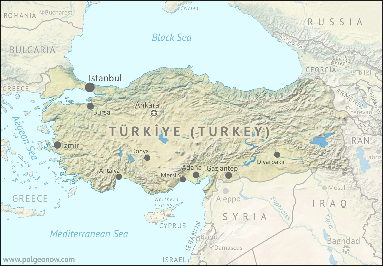
Map of Türkiye, formerly known as Turkey, which officially changed its name in English and other languages in 2022 to match the Turkish-language version. Map is in green, brown, and blue natural style with terrain, showing that more or less the entire country is mountainous, with colors varying from dark green to beige, and most areas in some hue of yellow-green. Turkey is roughly shaped like a long, horizontal rectangle (if north is treated as up), with the Black Sea along its whole northern side and the Aegean Sea to its west, with a small portion of the country in the far northwest (Eastern Thrace) separated from the rectangle (Anatolia) by the rivers connecting those two seas. The southern side of the country is bounded by the Mediterranean Sea in the west and the more-arid land of the Levant and Mesopotamia in the east. East of the country are the mountainous Southern Caucasus region and the northwestern end of the Iranian Plateau. Capital city Ankara is a bit northwest of the country's geographic center, and the larger Istanbul much farther to the northwest, straddling the gap between Eastern Thrace and Anatolia. Other cities of over a million people each, including İzmir, Adana, Bursa, Gaziantep, and several more, are located along the country's western and southern margins. Surrounding countries include Greece and Bulgaria to the west; Cyprus (and disputed Northern Cyprus), Syria, and Iraq to the southeast; and Iran, Armenia, Georgia and Azerbaijan to the east. Russia looms large just across the Black Sea to the northeast, Romania is across the sea to the northwest (plus Ukraine and disputed Crimea directly north), and Israel and Lebanon are not far off along the southward turn the Mediterranean coast, while the Aegean Sea to the west is dominated islands that are part of Greece.
Hidden image for crawlers

Turkey's "New" Name

Over the last two years, PolGeoNow readers might have noticed us using the name "Türkiye" for the country more widely known in English as "Turkey". That's because the Turkish government officially changed the country's name in English (and two other languages) about two years ago, and our policy is to call countries by what their governments say they're called, except in certain special cases. 

Türkiye, a large and influential country traditionally considered to be partly in Europe and partly in Asia, comes up a lot in news about both European and Middle Eastern geopolitics. So that means a lot of people and organizations now have to make a choice: Keep using the name they're used to, or switch the official one chosen by the country's government.